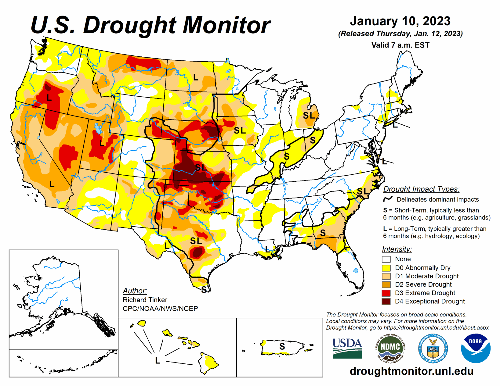
A series of atmospheric rivers led to heavy rain and high-elevation snow across parts of the West, especially across California. Precipitation totals exceeding 4 inches (liquid-equivalent) were widespread, and several areas in and near the Sierra Nevada, Cascades, and coastal ranges recorded over one foot of precipitation.
Moderate to heavy precipitation was also common along the coast and in the higher elevations of the Pacific Northwest, some higher elevations in the central and northern Rockies, part of the upper Midwest, portions of the lower Mississippi Valley, the interior Southeast, and scattered locales across the Ohio Valley and the Northeast. Precipitation totals generally exceeded 1.5 inches, and topped 4 inches in parts of the Southeast, central Utah, and the higher elevations in the Pacific Northwest.
Much of the precipitation fell on areas experiencing dryness and drought, so across the country, improvement was much more common than deterioration. Mild temperatures prevailed across the country except where significant precipitation was observed in the northern Plains and Far West. Daily high temperatures averaged more than 12 deg. F above normal in central and southern Texas while daily low temperatures averaged 10 to 13 deg. F above normal across the Great Lakes, the Southeast, and the southern Plains.
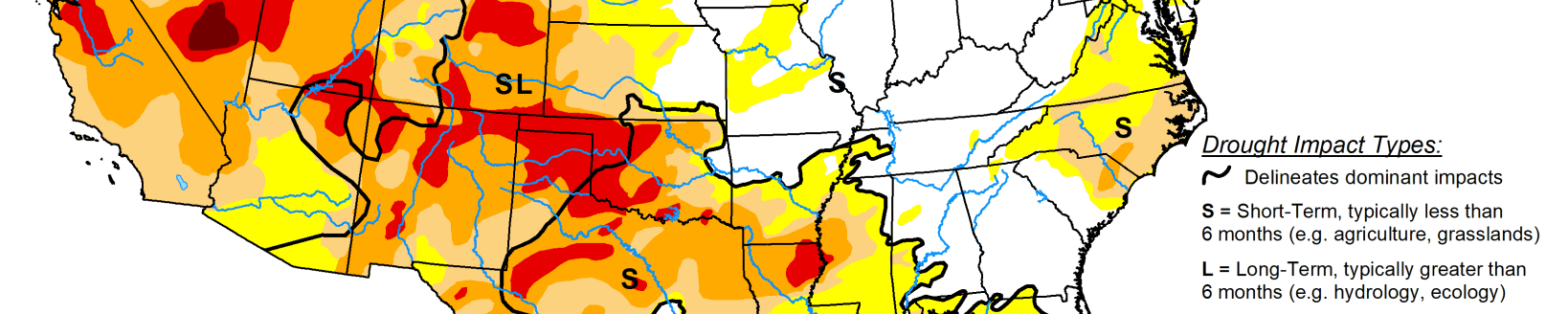
South
Moderate to locally heavy rain in Tennessee and Mississippi kept those states free from drought. The small area of D0 remaining in Tennessee was removed, and D0 areas in Mississippi contracted slightly. Moderate to locally heavy rain also fell on most of Louisiana and eastern Texas. Farther west, little or no precipitation fell. Exacerbated by much above normal temperatures, conditions deteriorated in portions of Texas and Oklahoma, although most locations were unchanged by the week’s dryness. Much of Oklahoma remained in extreme drought (D3), and similarly dry conditions existed across scattered areas in central and northern Texas. Exceptional drought (D4) now covers part of central Texas, scattered areas across Oklahoma, along with the northern tier of the state. 90-day precipitation amounts were only 10 to 25 percent of normal through the Oklahoma Panhandle, part of adjacent Texas, and in far western Texas from Big Bend National Park northwestward for a few hundred miles along the Rio Grande. Locations in and near the central Texas D4 region recorded 3 to 5 inches less precipitation than normal during this period.
Midwest
It was a wet week across most of Kentucky, with many locations from east of the Ohio/Mississippi Rivers’ confluence to the Appalachians receiving 1 to locally 4 inches. Meanwhile, light to locally moderate precipitation fell on portions of Minnesota and the Great Lakes Region, much of it in the form of snow. Most areas recorded several tenths of an inch of precipitation (liquid-equivalent), but a few swaths from southeastern Minnesota through the Upper Peninsula of Michigan reported 1 to 2 inches. A fairly deep snowpack now covers most areas across the northern tier of the Midwest Region. As a result, improvements were introduced there, particularly from the Upper Peninsula of Michigan through southern Minnesota. Most areas from eastern Missouri northeastward through much of the Lower Peninsula of Michigan recorded 2 to 6 inches less than normal precipitation over the last 3 months, with the largest deficits observed near the Ohio River; however, most of the Midwest Region has seen near- to above-normal precipitation during the past 30 days, with totals about 2 inches above normal through much of the northern tier of the Region. Currently, northwestern Iowa is the driest part of the Region. Much of this area is in extreme drought (D3) with a small area of D4 assessed near the Nebraska border.
High Plains
Most of the region was much drier than the prior week, with a few tenths of an inch of precipitation restricted to southeastern South Dakota and adjacent portions of Nebraska, as well as isolated sites in the higher elevations of Colorado and southern Wyoming. Other areas recorded little if any precipitation. Most of the region remained unchanged from last week, but some improvement occurred in southeastern South Dakota and adjacent Nebraska.
No areas appeared to deteriorate significantly due to the heavy precipitation of the previous week and seasonably cold temperatures reducing human and natural water demand. But most of the region remained in at least moderate drought (D1), with extreme to exceptional drought (D3-D4) stretching from southeastern Wyoming eastward across most of Nebraska into adjacent Iowa, and southward from western Nebraska through most of southern and western Kansas. A broad swath covering the southwestern half of Kansas and much of northeastern Nebraska remained in exceptional drought (D4).
Related Articles