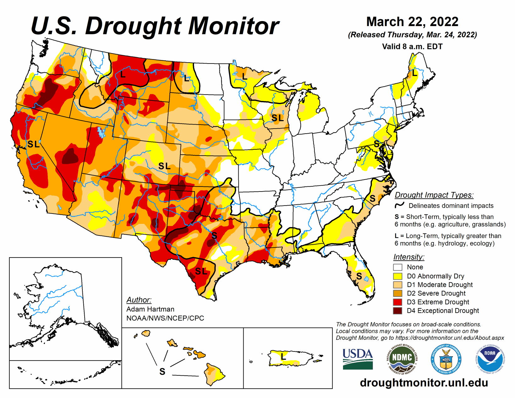
A series of storm systems moved across the lower 48 states this past week. Heavy rain fell across parts of the Great Plains and Southeast, with lighter amounts observed across parts of the Pacific Northwest and Intermountain West. The Central and Southern Plains, Lower Mississippi Valley, and Southeast mostly saw improvements to drought conditions, with several locations receiving more than 2 inches of rainfall (more than 5 inches, locally) during the 7 days leading up to March 22.
Throughout much of the U.S., where antecedent dryness coincided with below-normal precipitation, drought either continued or worsened in intensity. The only areas where this was not true was across parts of the Upper Midwest, which experienced some removal of long-term drought due to improvements from melting snow cover.
South
Two storm systems brought heavy rainfall across much of the Southern Region this past week. The first system dropped heavy rain across parts of central Louisiana and much of Mississippi before moving eastward very early in the period (March 15-16). The second storm system intensified over the Southern and Central Plains in the final day leading up to March 22, dropping heavy rain across central and eastern Oklahoma and northern and eastern Texas, extending eastward to the Mississippi River. Rainfall totals across many of these areas exceeded 2 inches, leading to large swaths of 1-category improvements in the drought depiction. The 2-category improvements were also warranted in isolated locations receiving, in some cases, more than 5 inches of rain.
Given the short-term nature of the drought, soil moisture indicators and stream flows responded quickly, leading to more aggressive improvements in eastern Oklahoma, eastern Texas, and the Ark-La-Tex. Farther west and south in Texas, many locations missed out entirely, receiving little to no precipitation this past week. This increased rainfall deficits that go back several months, resulting in the continued deterioration of drought across these areas.
Midwest
Abnormal dryness (D0) and moderate drought (D1) was reduced in coverage across parts of southwestern Iowa and northern Missouri this past week. A storm system that intensified over the Central and Southern Plains March 21-22 brought more than 2 inches of rain to these areas, reducing short-term (30 to 90 day) precipitation deficits. Moderately heavy rainfall also extended into portions of the central Corn Belt.
However, despite many locations receiving upwards of 0.5 to 1 inch of above-normal rainfall, long-term drought is firmly entrenched in these areas, leading to a status quo depiction this week. Farther north across parts of northern Wisconsin and northern Michigan, a mix of snowmelt and 7-day precipitation totals led to some removal of D1, as root zone soil moisture and groundwater are beginning to recover, in addition to near and above-normal average stream flows. Conversely, D1 remains in adjacent areas in northwestern and northeastern Wisconsin, extending into the south-central Upper Peninsula of Michigan, where deeper soil moisture and groundwater indicators are recovering more slowly. Elsewhere in the Midwest, conditions are near or wetter than normal, leading to much of the southern Great Lakes and eastern Corn Belt remaining drought-free.
High Plains
Associated with a storm system intensifying and moving slowly northeastward from the Central Plains March 21 to 22, heavy rainfall was observed across much of central and eastern Kansas, southeastern Nebraska, and eastern Colorado. Rainfall in excess of 1.5 inches resulted in 1-category improvements across many of these areas. However, improvements were less widespread for some locations in central Kansas and southeastern Nebraska, as longer-term deficits remain intact. Additionally, soil moisture still remains D2-equivalent (indicating severe drought conditions) or worse across many areas, region-wide stream flows are running near and below normal, and standardized precipitation indices (SPIs) are D2-equivalent or worse for all periods between 60 and 120 days. Farther north across western North Dakota and southern South Dakota, the lack of seasonal snow cover, above-normal temperatures this past week (10 °F to 15°F above-normal), and high winds resulted in the expansion of extreme (D3) and severe (D2) drought, respectively.
Reports from western North Dakota indicate rangeland conditions are worse than this time last year. Groundwater and root zone soil moisture is very low and watering holes are dried up, supported by NASA GRACE groundwater and NASA SPoRT 0-100 cm soil moisture indicators. In southern North Dakota, shallower soil depths (0-40 cm) have dried out further this past week due to above-normal temperatures and high winds. Additionally, SPIs are at D2-equivalent or worse for all periods going back 120 days. Locals continue to be concerned about the antecedent dryness leading up to the spring. Water availability, forage for feed, and livestock are all at risk if the rains do not come during the spring and summer months, as the Northern Plains begins transitioning into a climatologically wetter time of year in April.
West
Following a very wet December 2021 across parts of the West, a very dry pattern has persisted during much of 2022 so far, mainly from southern Oregon southward. Average basin snow water equivalent (SWE) values have continued to decline across the West and are now below-normal since the start of the water year (October 1, 2021). Despite the drying trend leading up to this week across many areas of the region, a stormy pattern brought above-normal precipitation to the windward (west-facing) slopes of Washington, with some additions to the snowpack. Snowpack gains were also evident across parts of the Northern Rockies. Given the smalls gains made over the past couple of weeks, targeted improvements were made across northern Oregon, northern Idaho, and western Montana. Additionally, sub-basin average SWE values are near and slightly above-normal for the water year, USGS average stream flows are running near and above-normal, and standardized precipitation evapotranspiration indices (SPEIs) are D0 to D1 equivalent (indicating abnormally dry to moderate drought conditions) for all periods going back 6 months.
However, longer-term drought remains entrenched across much of the West, supported by NASA GRACE shallow groundwater remaining below the 5th percentile for many areas. Deterioration of drought was also observed in northwestern California, where 7-day precipitation was below-normal again this week. Widespread along the coastal ranges of northern California, USGS 28-day average stream flows are below the 5th percentile of the climatological distribution, with more having fallen into the bottom 1 percent of their respective distributions for the same period. Groundwater, soil moisture, and SWE are all below-normal and nearby reservoir levels are, on average, 50 percent of their historical averages as we begin transitioning into a drier time of year.
Elsewhere in the Western Region, a low pressure system tracking eastward in the days leading up to March 22 produced enough precipitation and high elevation snowfall to stave off any further degradation this week. Some basins across the Four Corners region are even reporting near and above-normal seasonal snowpack following the event. However, more will be needed to curb long-term drought across these areas.