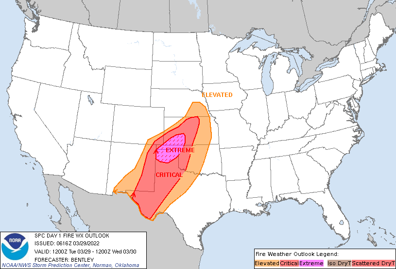
In a March 29 Fire Weather Update, the National Weather Service’s Storm Prediction Center in Norman, Oklahoma, said, “A significant wildfire outbreak is likely across the southern High Plains.”
The update emphasized an extremely critical fire weather area for the northern Texas Panhandle into southwest Kansas and a critical fire weather area for a large portion of the southern High Plains into northern Kansas.
The fire outlook noted, “A strong upper-level jet streak will advance from the southwest into the southern High Plains today. The core of this jet streak will extend from southeast New Mexico into southwest Kansas this afternoon.”
Strong winds beneath a mid-level jet streak will clear cloud cover and allow for strong surface heating. Low relative humidity, warm temperatures and dry fuel will make conditions ideal for fires, and high winds this afternoon will make any fires that start spread rapidly, according to NWS.
“By the afternoon, a broad region of 12% to 18% relative humidity and sustained winds of 35 mph to 40 mph with gusts 65 mph to 70 mph are expected from the Texas Panhandle into central Kansas. Extremely critical meteorological conditions will likely extend as far as north-central Kansas, but fuels are somewhat less favorable with northern and eastern extent.”
In a video posted to the Kansas Forest Service’s Facebook page, meteorologist Chip Redmond warned, “That’s extreme fire weather. We will see fires burn extremely aggressively and be nearly impossible to stop.”
He urges those in the fire weather area to make sure any existing prescribed burns are completely extinguished—then check again to make sure that any hot spots won’t reignite.
Redmond said winds will shift direction 90 degrees as a cold front moves in after sunset, which would also affect efforts to put out any wildfire outbreaks.
Follow the National Weather Service for more information.
Shauna Rumbaugh can be reached at 620-227-1805 or [email protected]


