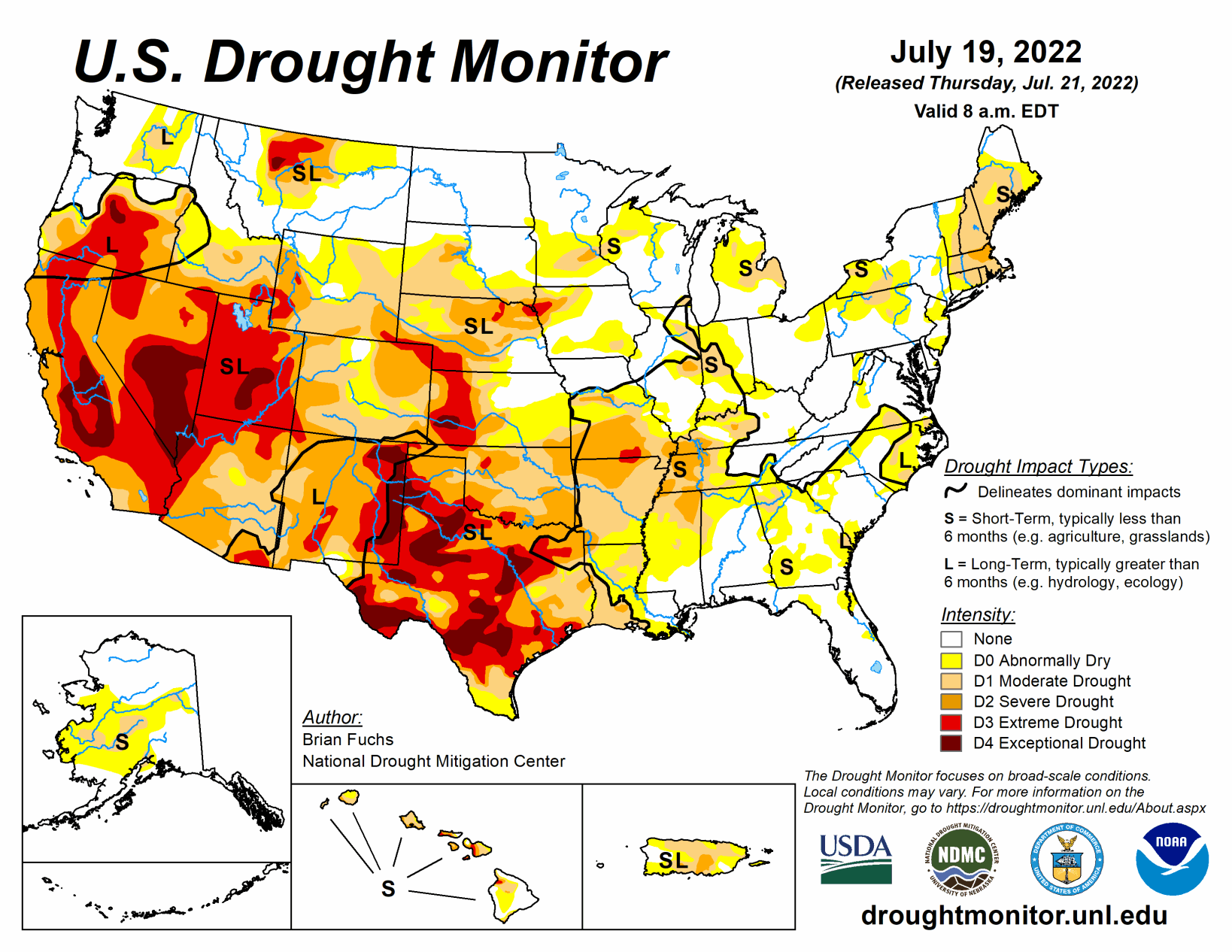
Most of the eastern third of the U.S. recorded precipitation during the last week, with only a few pockets that missed out. Portions of the Midwest and into the Southeast had some amounts over 3 inches for the week. The areas with the most rain also had the coolest temperatures, with much of the Midwest and Southeast cooler than normal for the week with departures of 2 to 4 degrees below normal.
Warmer-than-normal temperatures dominated the western half of the country with areas from Montana to Texas recording temperatures that were 6 to 8 degrees above normal. The coastal areas of the Pacific Northwest were cooler than normal while the Great Basin was warmer than normal with departures of 6 to 8 degrees above normal. With the dryness and heat, the flash drought that has been developing in the central to southern Plains developed even more this week with the wet conditions of May and June quickly being forgotten.
South
As with areas of the central Plains, the South had widespread hot and dry conditions for the week. Areas of northeast Arkansas, western Louisiana and northern Mississippi had the most rain, with pockets of rain throughout central and southern Texas. Temperatures were warmer than normal with departures of 4 to 6 degrees above normal over most of northern Texas and Oklahoma.
As both long-term and short-term dryness have impacted this area, extreme and exceptional drought expanded over Oklahoma and Texas while flash drought development has impacted much of eastern Oklahoma into Arkansas. Widespread degradation took place this week with a full category degradation over much of Oklahoma, Arkansas and into northern Texas. Further degradation took place over portions of east Texas with just small areas of improvement over far west Texas, the western Panhandle and into southwest Texas.
Midwest
Another week where most of the eastern portions of the region recorded above-normal precipitation, with the greatest amounts through Kentucky, southern Illinois, southern Indiana and northern Ohio as well as in portions of northern Wisconsin. Warmer-than-normal conditions were recorded from Minnesota to Missouri, where flash drought conditions continue to develop in the southern half of the state. Missouri had widespread degradation this week with most of the southern half of the state experiencing a full category degradation on the U.S. Drought Monitor.
High Plains
A warm and mainly dry week dominated the region. Temperatures were warmest in eastern Montana and from western North Dakota to western Kansas, where departures were 6 to 8 degrees above normal. There were some pockets of very intense rains in Nebraska, North Dakota and eastern Colorado, but widespread rains were minimal. South Dakota had expansion of abnormally dry and moderate drought over much of the southern tier of the state while eastern Kansas had widespread introduction of abnormally dry conditions and moderate drought expansion.
Severe and extreme drought expanded over much of western Kansas while severe drought expanded over north-central Nebraska and in the panhandle. Severe drought also expanded on the plains of eastern Colorado and extreme southeast Wyoming. There was a slight improvement in extreme drought in northeast Nebraska where some intense rains fell in the middle of the previous extreme drought area.
West
Temperatures were warmer than normal over much of Montana and into northern Nevada, southern Idaho, and eastern Wyoming with departures of 6 to 8 degrees above normal. Temperatures were cooler than normal by 1 to 2 degrees over the coastal regions of Washington and Oregon. Highly variable and scattered monsoonal moisture continues to impact the region, with some areas with above-normal precipitation for the week in Nevada, Arizona, and southern California as well as into areas of southern Colorado and Utah. Only minimal changes were made this week as the full impact of the recent precipitation is not fully known yet, but improvements are possible depending on how the rest of the monsoon season continues.