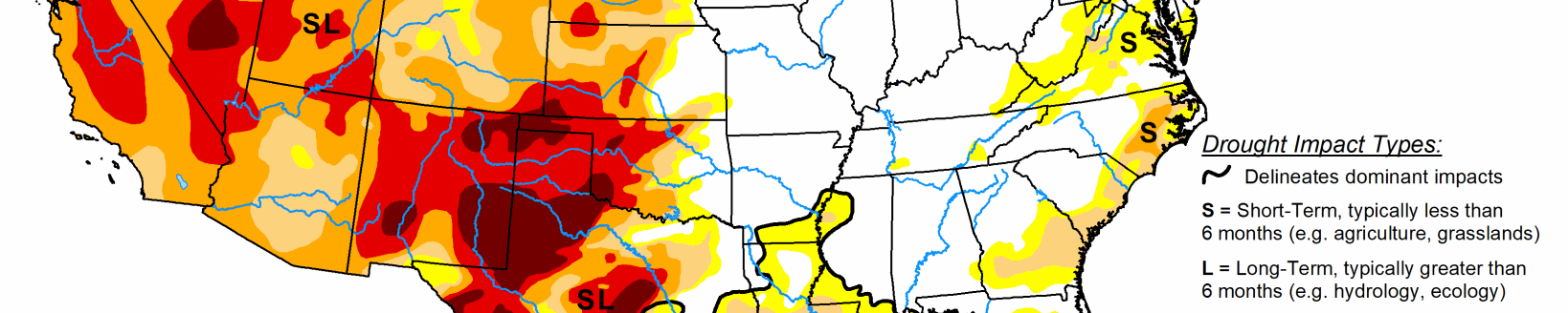
Record-breaking rainfall significantly improves drought conditions in the South

Record-breaking rainfall led to aggressive improvements in drought conditions across parts of the South. The heavy rainfall and flooding led to communications outages at the National Weather Service office, leaving climatologists without access to important data and tools needed to fully analyze the effect of this event.
The magnitude of this event meant prioritizing improvements on this week’s map in these areas and in the Southwest, where the Monsoon season remains active. Drought expanded in the Northwest was warm, dry conditions continued across the region. The Midwest, Southeast, and Northeast saw a mix of improvements and degradations.
South
This week’s storm event led to broad 1- and 2-category improvements across large parts of the South. All states in the region show improvements. Rainfall close to the data cutoff time (Aug. 23 at 8 a.m. EDT), data communications issues caused by the flooding, and lags in the hydrologic system in response to rainfall events means that the full impact of this storm on drought conditions is not yet apparent.
Analysis will continue next week as more data become available. A few impressive statistics include the following. According to National Weather Service records, prior to this week’s event, the Dallas-Fort Worth Area went 67 days without measurable precipitation, the second longest streak on record going back to 1898. The Aug. 21 to 22, 24-hour total of 9.19 inches tied for the second highest 24-hour total. The Texas State Climatologist noted that the largest flood control rain gauge total was 15.16 inches.
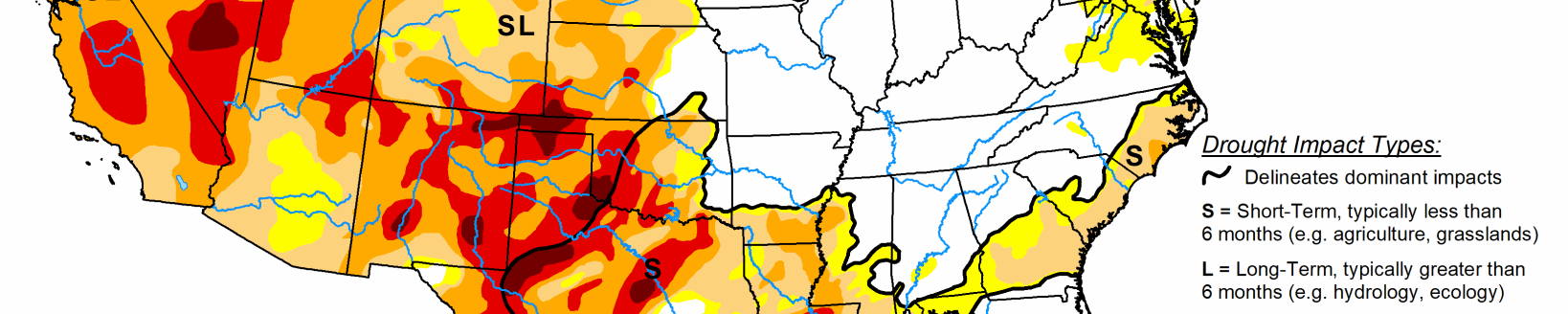
Midwest
Spotty, heavy rain fell across the Midwest this week leading to a mix of drought improvement and deterioration. Moderate drought (D1) improved in western Kentucky in response to above normal rainfall over the past 30 days. Meanwhile, nearby counties that missed these recent heavy rains saw an expansion of D1.
In Missouri, rainfall of 150% to 300% of normal for the week led to broad 1-category improvements to areas of moderate (D1), severe (D2), and extreme (D3) drought. Totals of 1 to 4 inches erased short term moisture deficits, replenished soils, and restored streamflows. Central Minnesota also saw improvements to D1 in response to recent rainfall and seasonable temperature.
Moderate drought increased near the Iowa border where deficits of over 5 inches over the last 90 days dried out soils and lowered streamflows. Additional analysis across the Midwest next week is likely to result in increasing drought severity across Iowa due to persistent dry weather.
High Plains
Warm, dry conditions continued across the region. Moderate drought (D1) expanded in western South Dakota and northeast Wyoming where rainfall deficits of near 3 inches over the last 90 days dried out soils, lowered streamflow, and stressed vegetation. Additional analysis across the High Plains next week is likely to result in increasing drought severity across parts of the region due to persistent dry weather.
West
An active monsoon season in the Southwest led to improvements to drought conditions. Precipitation has improved many drought indicators including soil moisture, streamflow, and well data. Moderate drought (D2) improved in northern and southern Arizona. Moderate (D2) and extreme (D3) drought improved in southern and eastern New Mexico. Extreme drought (D3) improved in Utah and Nevada.
Additional improvements are expected next week as the effect of the recent rainfall continues to be analyzed. To the north, Idaho and Montana saw an expansion to abnormally dry areas. Persistent warm, dry weather is likely to lead to additional degradations as soils continue to dry and vegetation suffers.