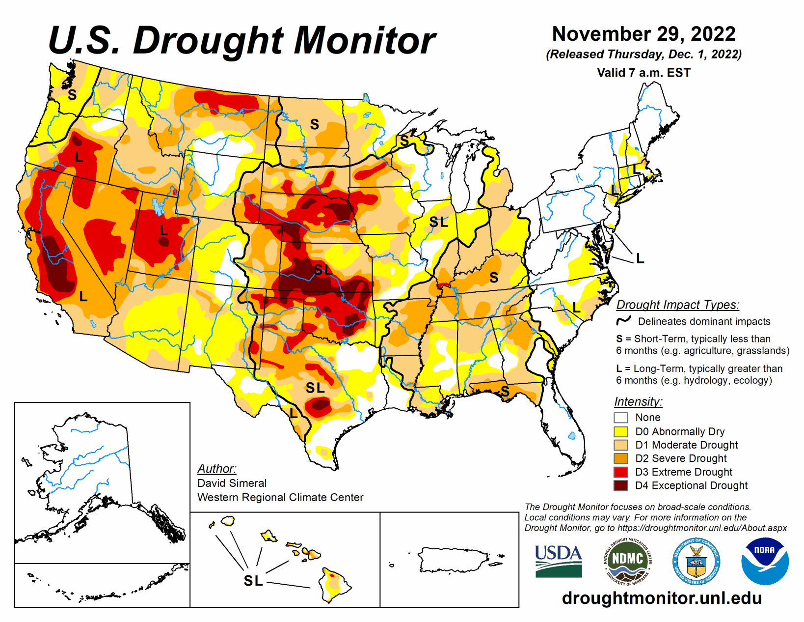
This U.S. Drought Monitor week saw areas of moderate to heavy rainfall along the central and western Gulf Coast region as well as areas further inland in the eastern half of Texas, southeastern Oklahoma, and southwestern Arkansas. In these areas, targeted improvements were made in drought-affected areas.
Additionally, an outbreak of severe weather, including severe thunderstorms with tornadoes and wind damage, impacted areas of the South (Louisiana, Mississippi, and Alabama) overnight on Tuesday (Nov 29), resulting in severe damage and loss of lives reported.
In the High Plains, generally dry and warmer-than-normal temperatures (2 to 10+ deg F above normal) prevailed across much of the region during the past week. Out West, drought-related conditions improved in areas of Arizona, New Mexico, Nevada, Washington, Colorado, Wyoming, and Montana.
Looking back at the last several months, the contiguous U.S. experienced its 8th warmest September-October period on record since 1895 in terms of average temperatures (+2.2-deg F anomaly) and maximum temperatures (+2.6 deg F), according to NOAA National Centers for Environmental Information (NCEI). Precipitation in the contiguous U.S. during the September-October 2022 period ranked as the 11th driest (-1.14-inch anomaly).
South
In the South, improvements were made across areas of the eastern half of Texas, southeastern Oklahoma, western Arkansas, and southern Mississippi where locally heavy rainfall accumulations (3 to 8+ inches) were observed. Despite this week’s rainfall in portions of Texas, streamflows in the Hill Country remain below normal with numerous gauging stations reporting levels in the bottom 10th percentile, according to the USGS.
Midwest
For the week, precipitation accumulations ranged from light to moderate (1 to 4 inches) with the heaviest accumulations observed in western Missouri as well as in isolated areas of central Kentucky and northern Indiana. Additionally, some light-to-moderate snowfall accumulations were observed across portions of Minnesota, northern Wisconsin, and Upper Peninsula Michigan. Precipitation this week led to improvements in Ohio, Indiana, and Missouri, while conditions deteriorated in southern Michigan and northern Illinois where areas of Moderate Drought (D1) expanded. In terms of climatological rankings, the Upper Midwest Climate Region had its 6th driest (-2.25-inch anomaly) September-October period, with Minnesota having its 3rd driest (-2.68-inch anomaly) for the contemporaneous period.
High Plains
On this week’s map, improvements were made on the map in the greater Denver-Boulder area of Colorado and in portions of eastern Wyoming in response to above-normal precipitation in the short-term. Elsewhere in the region, no changes were made on the map. For the week, average temperatures were well above normal across the Northern Plains with average temperatures ranging from 2 to 10+ deg F above normal. However, the warmer temperatures melted the portions of the snow in areas of North Dakota allowing for beneficial percolation of meltwater into the still-unfrozen soils. According to NOAA NCEI, the Great Plains Region saw its 9th warmest (+3.0-deg F anomaly) and 8th driest (-1.4-inch anomaly) September-October on record. Statewide, Wyoming experienced its 3rd warmest (+4.2-deg F anomaly) and Colorado its 8th warmest (+3.1 deg F anomaly) September-October period on record.
West
Out West, some minor changes were made on the map in southeastern Arizona, southern New Mexico, east-central Nevada, and north-central Montana. In east-central Nevada, areas of Extreme Drought (D3) were reduced in White Pine County in response to improving conditions following above-normal precipitation during the monsoon season as well as from above-normal SWE levels currently observed in the Schell Creek and Snake ranges. Likewise, in southeastern Arizona and southwestern New Mexico, above-normal precipitation during the monsoon season as well as over the past several months led to the removal of areas of Severe Drought (D2). F
urther to the north in Montana, above-normal precipitation since the beginning of the Water Year (Oct 1), led to reduction of areas of Extreme Drought (D3). In terms of snowpack conditions across the region, near-normal to above-normal SWE levels are being reported across the basins of the Sierra Nevada, Great Basin ranges, Cascades, Northern Rockies, Wasatch, and areas of the Central Rockies. Further south, the basins of Southwest Colorado and the Rio Grande are currently below normal. For the week, average temperatures continued to be cooler than normal (2 to 10 deg F below normal) across much of the region except for areas of Northern California, Montana, and eastern portions of Colorado and Wyoming.
According to NOAA NCEI, the September-October 2022 period was the warmest (+4.3-deg F anomaly) on record for the Rockies and Westward Region, 3rd warmest for the West Climate Region (includes California and Nevada) (+4.8-deg F anomaly), and warmest on record for the Northwest Climate Region (+5.5-deg F anomaly).