Southern Plains still feeling the impact of drought
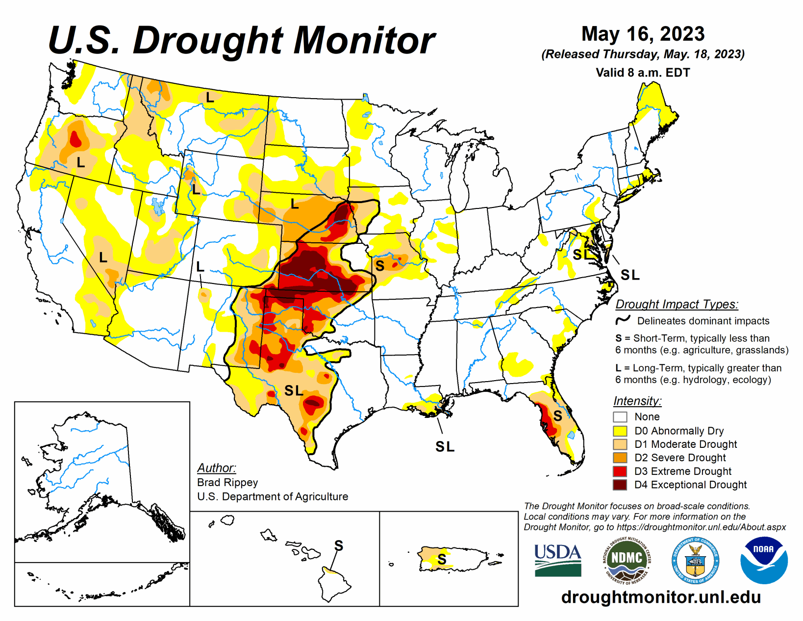
A complex, slow-moving storm system delivered heavy rain across much of the nation’s mid-section, but largely bypassed some of the country’s driest areas in southwestern Kansas and western Oklahoma, as well as neighboring areas, according data collected through May 16.
Still, the rain broadly provided much-needed moisture for rangeland and pastures, immature winter grains, and emerging summer crops. Significant rain spread into other areas, including the southern and western Corn Belt and the mid-South, generally benefiting crops but slowing fieldwork and leaving pockets of standing water. Excessive rainfall (locally 4 to 8 inches or more) sparked flooding in a few areas, including portions of the western Gulf Coast region.
Little or no rain fell across much of the remainder of the country, including southern Florida, the Northeast, the Great Lakes region, and an area stretching from California to the southern Rockies. Warmth in advance of the storm system temporarily boosted temperatures considerably above normal across parts of east-central Plains, western Corn Belt, and upper Great Lakes region.
Most of the region remained free of drought, but moderate to exceptional drought (D1 to D4) persisted in parts of central and western Texas and across the northwestern half of Oklahoma. During the drought-monitoring period, ending on the morning of May 16, extremely heavy rain drenched the western Gulf Coast region, especially near the central Texas coast. On May 10, Palacios, Texas, measured 6.21 inches of rain—part of a very wet stretch that included an additional 3.93 inches on May 13-14.
Heavy showers extended northeastward into southeastern Oklahoma, northern Louisiana, Arkansas, and western Tennessee. By May 14, the U.S. Department of Agriculture reported that topsoil moisture was rated 30% surplus in Arkansas, along with 29% in Louisiana. Farther west, however, serious drought impacts persisted, despite spotty showers. Statewide in Texas, rangeland and pastures were rated 51% very poor to poor on May 14.
Any rain was generally too late for the southern Plains’ winter wheat, which is quickly maturing. More than half of the wheat—52 and 51%, respectively, in Texas and Oklahoma—was rated very poor to poor by mid-May. A recent estimate by the USDA indicated that 32.6% of the nation’s winter wheat will be abandoned—highest since 1917—including 70.1% of the Texas crop.
Nearly all the region’s drought was confined to areas west of the Mississippi River, where pockets of heavy rain greatly reduced the coverage of abnormal dryness (D0) and moderate to extreme drought (D1 to D3). Some of the heaviest Midwestern rain fell across southern Minnesota, where D0 and D1 quickly turned to flooded fields amid May 10-14 rainfall totals that locally reached 4 to 8 inches or more. East of the Mississippi River, there were several patches of D0, mainly in Illinois, with a few other areas being watched due to a short-term drying trend.
Phenomenal rainfall totals led to significant reductions in drought coverage, especially from eastern Colorado and northwestern Kansas into western North Dakota. Goodland, Kansas, received consecutive daily-record totals of 1.50 and 1.12 inches, respectively, on May 10 and 11. Daily-record totals topped 3 inches on the 11th in Imperial, Nebraska (3.56 inches), and Colorado Springs, Colorado (3.18 inches). That marked the wettest May day on record in Colorado Springs, toppling 2.34 inches on May 30, 1935.
In Denver, Colorado, where 2.92 inches fell on the 11th, it was the wettest calendar day since May 6, 1973, when 3.27 inches fell. Denver’s storm total (4.40 inches from May 10-12) represented more than 30 percent of its normal annual precipitation. During the week ending May 14, the USDA reported double-digit improvements in topsoil moisture rated very short to short in several states, including Nebraska (from 66 to 46%), South Dakota (from 38 to 19%), and Colorado (from