Drought persistent in heartland, latest map shows
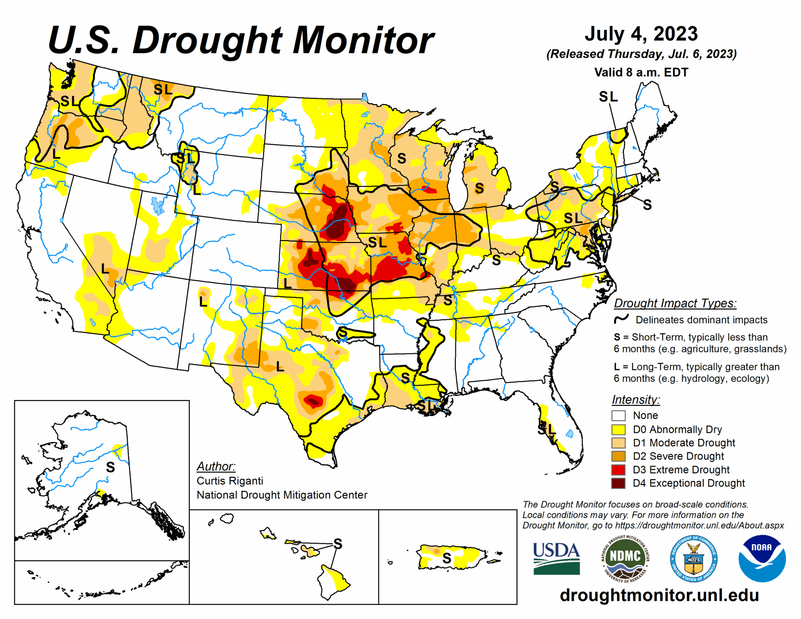
Heavy rains fell this week across parts of the Midwest, Ohio River Valley and Northeast, which led to widespread improvements from southeast Nebraska to central Illinois, southern Indiana, and central and eastern Kentucky.
To the south and west, in southern Missouri, the Texas-Louisiana border and other parts of central Texas, drier weather led to worsening precipitation deficits, and significant problems with hay production in parts of southern Missouri. Dry weather in the Upper Midwest led to further degrading conditions in parts of Michigan, Wisconsin and Minnesota. A re-evaluation of conditions in parts of the western Great Plains led to some improvements to long-term dryness and long-term moderate drought in the Texas and Oklahoma Panhandle region, and in western Nebraska and eastern Wyoming, respectively. A mix of degradations and improvements occurred in the Pacific Northwest. No changes were made to the USDM depictions this week outside of the Lower 48.
Much warmer-than-normal temperatures covered the South as it is enveloped in the continuing heat wave, especially eastern Texas and Louisiana where temperatures ranged from 4 to 8 degrees Fahrenheit above normal compared to the rest of the region where temperatures were near normal to 4 degrees above normal.
There was expansion of abnormal dryness and moderate drought along the western Gulf Coast where temperatures soared and little to no precipitation fell, providing no relief to the low streamflows and dry soil conditions.
This week’s weather in the Midwest region varied substantially, with heavy rain falling from St. Louis across much of central and northern Illinois, Kentucky, and parts of Indiana and Ohio to continued dry conditions in southern Missouri, eastern Wisconsin, and central and northwest Minnesota. Widespread changes occurred, as precipitation deficits grew and streamflow and soil moisture issues continued in locations that missed out on the rain, while drought and abnormal dryness improved to varying degrees in areas that saw more rain.
In southwestern portions of Missouri, major agricultural damage continued to occur as significant spring dryness has continued into the summer, and drought expanded and worsened. Localized worsening of conditions happened in parts of Iowa, which missed out on heavier rainfall. Extreme drought developed in and around Madison, Wisconsin, and severe drought expanded eastward to Milwaukee. Large-scale improvements occurred in parts of southern Iowa, northern Missouri, central Illinois, Chicago, southern Indiana, and central and eastern Kentucky, as well as parts of Ohio, where rainfall was sufficient to put a significant dent in precipitation deficits, increase streamflow, and improve soil moisture.
This week saw widespread improvements across the Great Plains. Much of the Great Plains portion of the region, with the exception of eastern Kansas, northern North Dakota and western Colorado, saw widespread precipitation, some of it heavy.
Much of southeast and northwest Nebraska, northeast South Dakota and along the Wyoming-South Dakota border saw rainfall of at least 2 inches over the last week. In western Nebraska, eastern Wyoming and the Dakotas, this led to widespread improvements to the drought depiction in areas where the heaviest rains fell. Nebraska saw the most improvements in the High Plains with continued improvement in the Panhandle, the Sandhills up to the South Dakota border and the southeast near Nebraska City. Meanwhile, conditions continued to worsen in a majority of Kansas, particularly in the east and southeast where mostly dry weather continued. Given continued decreases in soil moisture and groundwater, and growing short- and long-term precipitation deficits, degradations were made from Manhattan to Fort Scott.
With the exception of western portions of Washington and Oregon, much of the West region experienced near- or cooler-than-normal temperatures this week. Heavy rains fell in parts of southeast Montana, northwest Wyoming and adjacent portions of central Idaho and southwest Montana. These rains helped to alleviate long-term precipitation deficits and increase streamflows in these areas, leading to a reduction in coverage of ongoing drought and abnormal dryness.
Looking ahead
Showers and thunderstorms are expected to bring periods of heavy to excessive rainfall to drought-affected areas of the Central Plains and Midwest. Scattered thunderstorms are expected to linger across the southern tier of states. As a reminder, weather within this timeframe is after the data cutoff for this week and will be reflected on next week’s map. Heading into the weekend, the extended forecast (valid July 7 to 11) calls for hazardous heat across portions of California, the Southwest, the Southern Rockies, the South and the Southeast.
This expected multi-day heat wave could worsen existing drought conditions in these regions. Showers and thunderstorms are forecast for portions of the Central Plains, Midwest and South. Whether these rains will be beneficial and help ease drought concerns in these areas remains to be seen. While thunderstorms can produce large amounts of precipitation in a very short time, most of the rain runs off into drainage channels and streams. On the other hand, rain falling as light to moderate showers soaks into the ground, helps to recharge groundwater, sustains vegetation, and begins to chip away at moisture deficits that have built up during drought.
Next week, the Climate Prediction Center’s 6- to 10-day outlook (valid July 12 to 18) calls for an increased probability that the observed temperature, averaged over this seven-day period, will be above normal across the Southern Plains, much of the West, the Southeast and the Northeast. South Texas has an 80–90% chance that the average temperature will be above normal during this period. In general, the odds of a warmer-than-normal average temperature decrease moving northward.
The odds that the observed temperature, averaged over the same seven-day period, will be cooler than normal are highest in the Midwest (33 to 50%). Below-normal precipitation probabilities are increased across parts of the southern Plains, Nevada and the Four Corners Region. Utah has a 50–60% chance that the total precipitation over the seven-day period will be below normal. Meanwhile, the Midwest has the highest probability (40 to 50%) that observed precipitation totals will be above normal. Other areas with an increased probability of above-normal precipitation include parts of the Pacific Northwest, northern Plains, Midwest and Northeast.