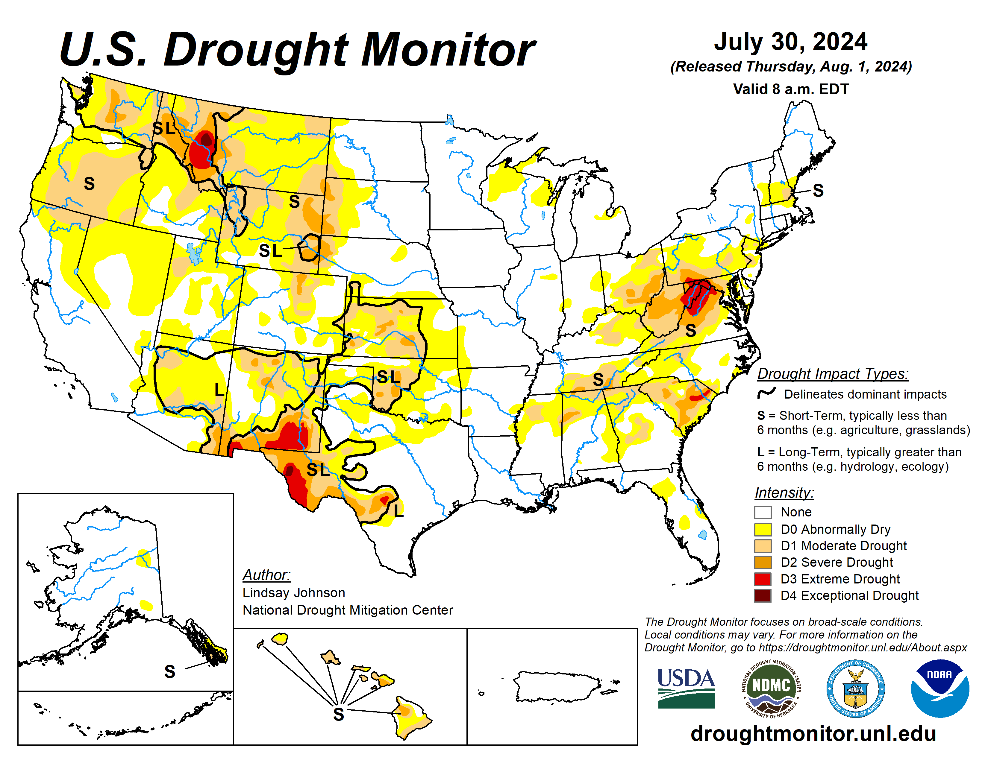
The 2024 drought is mostly centered now in Kansas, Oklahoma, New Mexico and west Texas as part of the U.S. Drought Monitor that looks at several regions and offers an outlook for the coming days.
The U.S. Drought Monitor is jointly produced by the National Drought Mitigation Center at the University of Nebraska-Lincoln, the U.S. Department of Agriculture and the National Oceanic Atmospheric Administration. (Map courtesy of NDMC.)
High Plains
The High Plains received trace amounts of precipitation, leading to already dry conditions in the western and southern High Plains to further deteriorate.
Poor soil moisture in much of Kansas brought about widespread 1-category degradations. In eastern Kansas, along the Missouri border there have been reports dryness and heat stress. Central Kansas has also seen reports of dry ponds and fear of total crop failures.
Some of these drier conditions spilled northward into southern Nebraska, which also saw areas of the northeast and western Panhandle deteriorate because of an extended period of dry conditions, dry vegetation, and low streamflow values. Similar conditions were seen across western South and North Dakota and Wyoming.
South
Eastern portions South saw much of the heavy precipitation seen in the Southeast. Southeastern Texas into western Louisiana recorded areas of over 8 inches of rain falling this past week. There was a sharp line of where the precipitation fell and did not. West of south-central Texas, northeastward to central Arkansas saw trace amounts of rain.
Temperatures were also between 1 and 4 degrees Fahrenheit below normal, with eastern Texas and western Louisiana having temperatures of 6 to 8 degrees below normal. Except for north-central Texas and parts of Oklahoma, and western Arkansas, 1-category improvements were made.
Oklahoma saw a mixture of above- and below-normal temperatures, with hot temperatures heating up at the end of the week (July 23 to 30). Reports of “cover crops being cooked” and “no soil moisture for native grasses to draw from and large pastures have lost much green color and have shrunk considerably” in central Oklahoma’s Logan County.
Midwest
The Midwest saw small degradations across the region despite the western and southern Midwest receiving some decent moisture. Missouri saw slight expansion of abnormal dryness along the Kansas border.
Northern Wisconsin into Michigan’s Upper Peninsula saw abnormally dry conditions introduced as it missed out on meaning full precipitation, along with drying vegetation, and soil moisture. Similarly, eastern Indiana and eastern Ohio saw 1-category deterioration, with reports of crop stress and pasture issues resulting in some areas in southeast Ohio having to haul in water.
West
Colorado saw deterioration in the northern Front Range, where extreme temperatures and low humidity made for perfect conditions for wildfires. Two fires were reported on July 29: the Alexander Mountain Fire west of Loveland and the Stone Mountain Fire southeast of Estes Park.
In the northern West, Montana saw slight improvements in the far north where temperatures were slightly below normal but saw similar conditions as North and South Dakota conditions in the central and eastern parts of the state. Central Utah saw minor expansion of abnormal dryness as streamflow began to drop and vegetation is looking dry.
Looking ahead
Over the period Aug. 1 to 6, the Midwest is expected to see 1 to 2 inches of rain with heavier amounts predicted in the eastern Midwest. An Atlantic disturbance noted by the National Hurricane Center shows a greater than 60% chance of developing into a tropical cyclone within the next two days Aug. 1 to 2. That could mean heavy rainfall along the Atlantic Coast. Isolated areas from Wisconsin, Minnesota, and Iowa to Kansas and higher elevations of Colorado, New Mexico, and Arizona are expected to receive around 1 inch of precipitation.
Otherwise, precipitation will be light and spotty leading to much of the West, Texas, southern Oklahoma and Arkansas missing out on the precipitation.
The National Weather Service Climate Prediction Center’s six- to 10-day outlook heavily favors above-normal temperatures from the Pacific Northwest across to the Southeast with conditions becoming near normal across the central U.S. Many of the lower 48 states are leaning toward above-normal precipitation, centering around Wyoming and Colorado.
Lindsay Johnson is with the National Drought Mitigation Center.


