Precipitation across the country was pretty much nonexistent over the past week.
The outliers were in Florida as Hurricane Milton came ashore and brought with it copious amounts of rain over much of the peninsula, as well as some rains in the upper Midwest into New England, and some coastal areas of the Pacific Northwest. From the Mississippi River west, most areas were warmer than normal, with departures of 9 to 12 degrees Fahrenheit or more above normal over much of the southern Plains, Rocky Mountains, and into the desert Southwest.
Cooler-than-normal temperatures were recorded along the Eastern Seaboard with departures of 3 to 6 degrees below normal quite common.
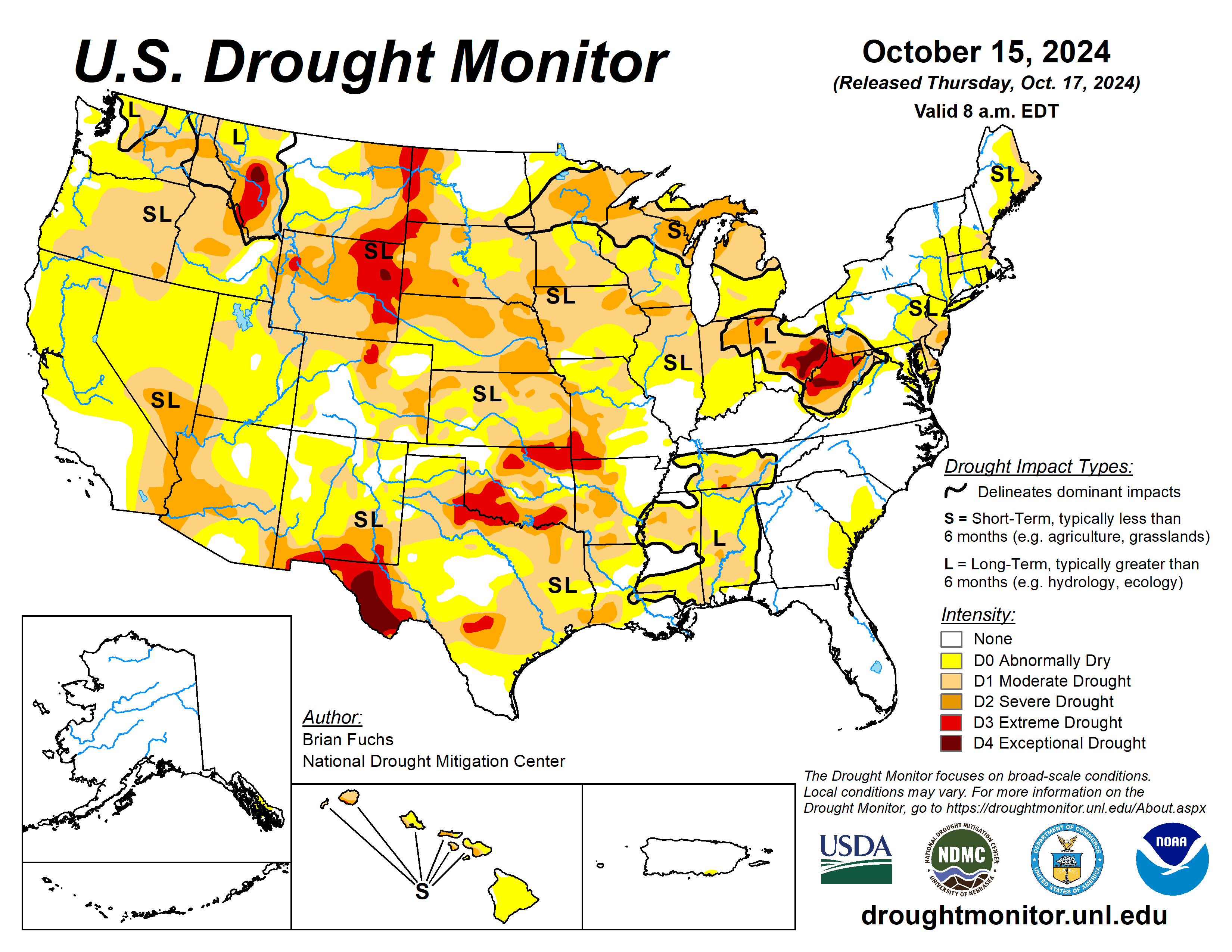
The U.S. Drought Monitor is jointly produced by the National Drought Mitigation Center at the University of Nebraska-Lincoln, the U.S. Department of Agriculture and the National Oceanic Atmospheric Administration. (Map courtesy of NDMC.)
South
Warm temperatures dominated the region with some areas of Texas having temperatures greater than 10 degrees above normal. The entire region was warmer than normal outside of far south Texas and portions of southern Louisiana.
Like the High Plains, precipitation was pretty much nonexistent in the region and coupled with the warm temperatures, degradation took place over much of the region. In Oklahoma, moderate and severe drought expanded in the central portions of the state while extreme drought expanded in the northeast. Northwest Arkansas had moderate, severe, and extreme drought all expand. Texas had widespread degradation over much of the east and central portions of the state as well as expansion of moderate drought over the Panhandle.
Severe and extreme drought expanded in the central portion of the state, where long-term indicators are showing drought at various timescales. Along the border with Oklahoma, severe and extreme drought expanded slightly.
Midwest
Temperatures were mixed across the region with the eastern areas and Michigan mainly near normal to 2 to 4 degrees below normal. Other areas were 2 to 4 degrees above normal for the week. Rain impacted the northern portions of Minnesota with some areas recording 100 to 150% of normal precipitation.
The rains brought some small improvements in northern Minnesota where severe drought eased to moderate drought. Other areas impacted by rain either slowed down the recent dry pattern or were not enough to flip the data to show improvements. Moderate and severe drought expanded into eastern Iowa. Moderate drought expanded over portions of central Iowa. Severe drought expanded over northwest Iowa and southwest and northern Minnesota.
Missouri had widespread degradation with moderate and severe drought expanding over central, southern, and western portions of the state and abnormally dry conditions filling in for central Missouri.
High Plains
The dry pattern continued over the High Plains with only a small area of North Dakota recording any precipitation.
The warm temperatures continued as well with most areas 4 to 8 degrees above normal and even greater departures of 8 to 12 degrees above normal in the plains of Wyoming and Colorado and portions of western Nebraska and South Dakota. Degradation took place from North Dakota to Kansas and into the plains of Montana, Wyoming, and Colorado. Moderate and severe drought were expanded in North Dakota, mainly in the south and west portions of the state.
South Dakota had moderate and severe drought expand in the northern, southern, and western portions of the state and had extreme drought expand in the northwest and a new area in southern portions of the state. Nebraska and Kansas both had severe and moderate drought expand over many areas of the state.
Kansas had extreme drought expand in the far southeast. Moderate and severe drought expanded over eastern Colorado and abnormally dry conditions expanded over portions of northeast Colorado and into Wyoming and Nebraska. Eastern Wyoming had moderate, severe, and extreme drought conditions expand.
West
As with the Plains and the South, most all of the West was dry this week with only some coastal areas of California and Washington measuring any precipitation. Warm temperatures dominated the region with almost everyone at least 3 to 6 degrees above normal for areas of Colorado and Wyoming and 9 to 12 degrees above normal for southern Montana.
New Mexico had severe and extreme drought expand over southern parts of the state, while abnormally dry conditions filled in more of the west. Moderate drought emerged in southwest Colorado, with severe drought expanding and a new area of extreme drought in the north central portions of the state. In Wyoming, moderate drought expanded over the southwest part of the state, severe drought expanded in the central area, and moderate drought expanded in the northwest.
Looking ahead
Over the next five to seven days, it is anticipated that much of the Rocky Mountain and central Plains areas will have the best chances for measurable precipitation. The highest amounts are anticipated over northeast New Mexico, southeast Colorado, and parts of the Oklahoma and Texas panhandles, where 2 or more inches may be recorded.
Most of the other areas are expecting an inch or less. Temperatures during this time are anticipated to be above normal over much of the Plains, Midwest, and into the Northeast, with departures of 10 to 15 degrees above normal over the upper Midwest. Cooler than normal temperatures of 2 to 4 degrees below normal are expected over the Four Corners region and the Rocky Mountains.
The six- to 10-day outlooks show that above-normal temperatures will continue for almost all of the country through the end of October, especially from Texas into the Midwest. The outlook shows the greatest chances of below-normal precipitation are from the Gulf Coast into the Midwest and over much of the East. The highest probabilities of above-normal precipitation will be in the central to northern Plains, northern Rocky Mountains and into portions of the Pacific Northwest.
Brian Fuchs is with the National Drought Mitigation Center.


