Midwest region received heavy rainfall
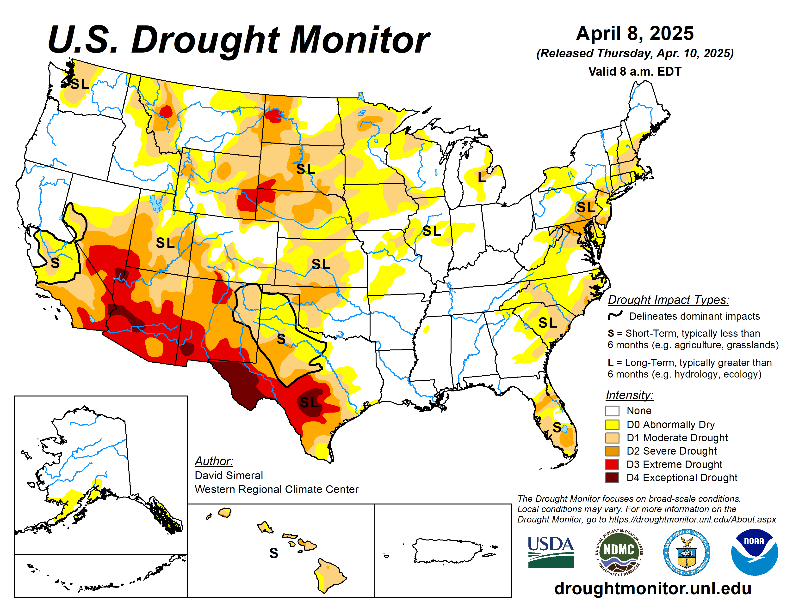
This U.S. Drought Monitor week saw widespread improvement in drought-related conditions across areas of the South, Southeast, and Midwest, where a series of strong storms delivered heavy rainfall, damaging winds, and severe flooding.
The multi-day storm event saturated soils leading to inundation of rivers, and severe flooding in low-lying areas from Arkansas to Ohio. Storm totals from the multi-day event ranged from 4 to 18+ inches, with the highest accumulations observed across central Arkansas, southeastern Missouri, and western portions of both Tennessee and Kentucky. In addition to heavy rainfall, the storm system sparked dozens of tornadoes as well as strong gusty winds in other areas, causing widespread power outages.
In the Midwest, the rainfall event pushed rainfall totals well above normal levels for the past 30-day period, leading to improvements across the Midwest including Missouri. In the Upper Midwest and portions of the Plains, drought-related conditions improved on the map across areas of Minnesota and South Dakota, where precipitation has been above normal for the past 30 to 90-day period and soil moisture monitoring products are showing normal to above-normal levels.
Looking at the current snowpack conditions out West, deep seasonal snowpack deficits remain across the ranges of southwestern Colorado and New Mexico. Elsewhere in the region, areas of the Great Basin and Intermountain West saw improvements on the map including parts of Wyoming and northwestern Colorado.
The U.S. Drought Monitor is jointly produced by the National Drought Mitigation Center at the University of Nebraska-Lincoln, the U.S. Department of Agriculture and the National Oceanic Atmospheric Administration. (Map courtesy of NDMC.)
South
Widespread improvements were made in response to very heavy rainfall accumulations observed across parts of the region, with the highest totals (ranging from 5 to 15+ inches) observed in northeastern Texas, eastern Oklahoma, Arkansas, western Tennessee, and southern Mississippi.
The multi-day storm event led to catastrophic flooding in parts of the region as well as tornadic activity, widespread power outages, and loss of life. However, the deluge of rains also led to significant improvements in drought-related conditions, with multiple category improvements made on the map. For the week, average temperatures were above normal in eastern areas, with anomalies ranging from 3 to 12 degrees Fahrenheit Conversely, the western extent of the region, including much of Texas, Oklahoma, and Arkansas, experienced temperatures ranging from 3 to 12 degrees below normal.
Looking at Texas reservoir conditions, statewide reservoirs are reported to be 75.7% full, with many reservoirs in the eastern part of the state in good condition (over 90% full), while numerous reservoirs in the western portion of the state continue to experience below-normal levels, according to Water Data for Texas (April 9). In terms of streamflow activity (April 9), the U.S. Geological Survey is reporting well above normals streamflows (>90th percentile) across northeastern Texas, southeastern Oklahoma and Arkansas, while areas of central and southern Texas are experiencing below normal levels (1st to 24th percentile range).
Midwest
Widespread improvements were made across the region in response to severe storm event that delivered very heavy rainfall accumulations and severe flooding to parts of the region including Missouri.
The multi-day storm caused widespread power outages, catastrophic flooding, damaging winds, and tornadic outbreaks. The rainfall improved conditions on the map in Missouri. Elsewhere in the region, above-normal precipitation during the past 30 to 90 days, led to reductions in areas of drought in Minnesota. Average temperatures were below normal across most of the region, with anomalies ranging from 2 to 8 degrees above normal.
High Plains
Improvements were made in the region, namely in northern Kansas, northern Nebraska, and South Dakota, where shorter-term precipitation (past 30 to 60 days) is normal to above normal. Additionally, these areas were showing improvements in other drought indicators including soil moisture, streamflow activity, and satellite-based vegetation health.
In western North Dakota, areas of extreme, severe and moderate drought expanded on the map in response to a combination of factors, including numerous recent impact reports from the agricultural sector, below-normal precipitation (past 30 days), and low streamflow and soil moisture levels.
For the week, generally dry conditions prevailed across western portions of the region, while eastern portions received modest accumulations of <1.5 inches (liquid). In terms of temperatures, below-normal average temperatures (ranging from 2 to 10+ degrees) were logged across the entire region.
West
Generally dry conditions prevailed over much of the region, including the Desert Southwest (southwestern New Mexico). However, some mountain locations in the Rocky Mountains received light-to-moderate precipitation accumulations.
Ongoing below-normal snowpack conditions (snow water equivalent at NRCS SNOTEL stations ranging from 6 to 55% of median) in the Nacimiento, San Juan, and Sangre de Cristo ranges of New Mexico, led to the introduction of areas of extreme (D3) drought. Elsewhere, some improvements were made on the map in drought-affected areas of northwestern Colorado and Wyoming.
Looking ahead
The National Weather Service’s Weather Prediction Center’s 7-Day Quantitative Precipitation Forecast calls for relatively dry conditions across the conterminous U.S., except for light-to-moderate accumulations across areas of the Pacific Northwest, northern Plains, Lower Midwest, Mid-Atlantic, and the Northeast.
The Climate Prediction Center’s 6-10-day Outlook calls for a moderate-to-high probability of above-normal temperatures across the western U.S., Plains, and areas of the South, while below-normal temperatures are expected across eastern portions of the Midwest and portions of the Northeast.
Elsewhere, near-normal temperatures are favored. In terms of precipitation, there is a low-to-moderate probability of above-normal precipitation across New Mexico, Texas and Oklahoma as well as areas of the Upper Midwest. Elsewhere, below-normal precipitation is expected across most of the West, Southeast and Mid-Atlantic.
David Simeral is with the Western Regional Climate Center.


