Heat and spotty rains hit Plains region
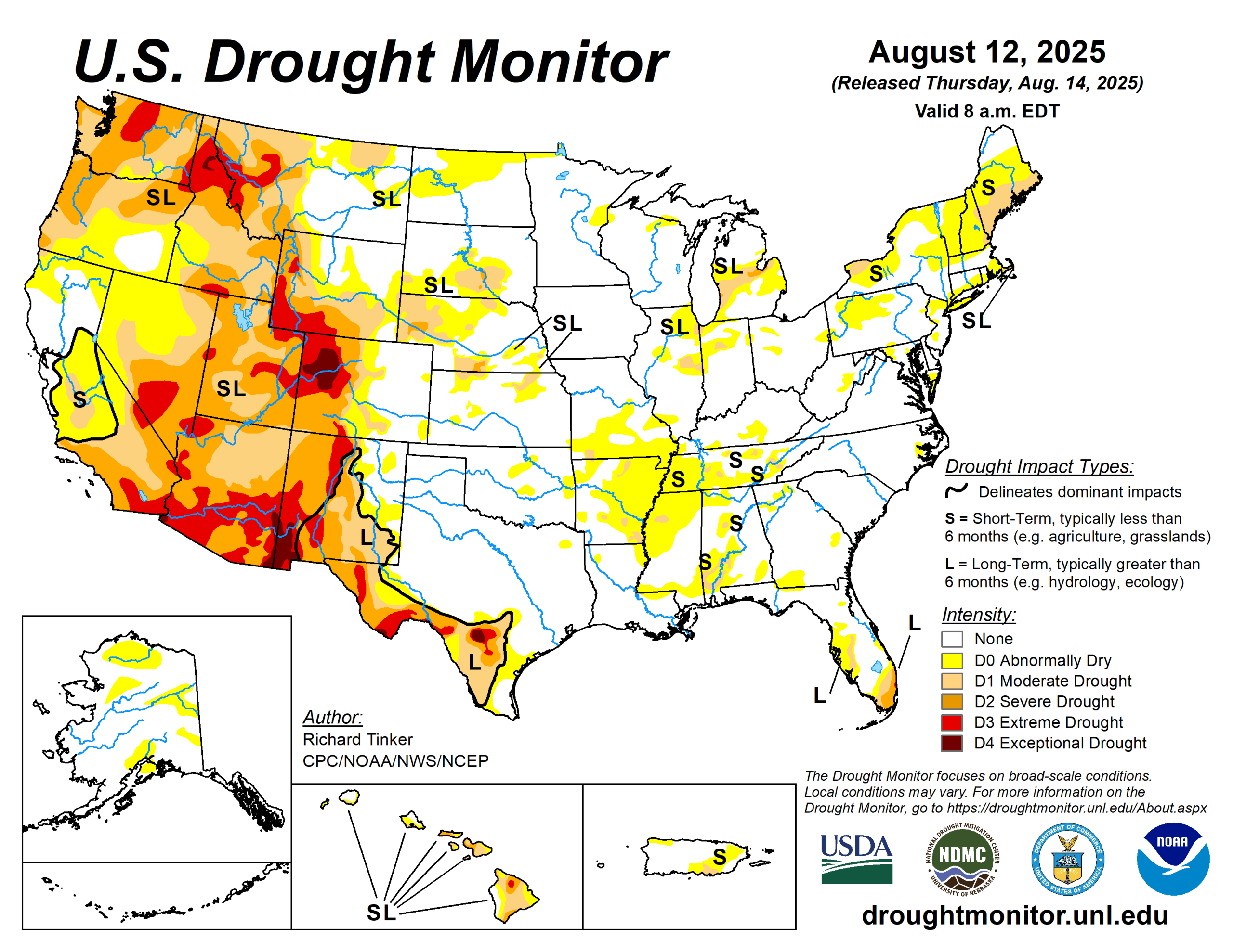
Intensifying short-term rainfall shortages led to expanding and intensifying dryness and drought over much of the Lower Mississippi Valley, Ohio Valley, Tennessee Valley, Northeast, and parts of the Deep South, southern Plains, central Arizona, and the central Rockies.
Meanwhile, a second consecutive week with moderate to heavy precipitation led to areas of improvement in the South Atlantic States from the Carolinas through Florida, across northern reaches of the Rockies and Plains, and over parts of the central Great Plains. The heaviest amounts (8 to 11 inches) doused areas in southeast Wisconsin from central Washington and Ozaukee Counties southward through much of north and central Waukesha and Milwaukee Counties.
Meanwhile, 6 to 8 inches were dropped on a broader section of southeast Wisconsin as well as a few patches across southeast South Dakota, the Carolinas Piedmont and adjacent southern Appalachians, the coastal Carolinas, north-central Florida, the central Florida Peninsula, and interior southeast Florida.
The U.S. Drought Monitor is jointly produced by the National Drought Mitigation Center at the University of Nebraska-Lincoln, the U.S. Department of Agriculture and the National Oceanic Atmospheric Administration. (Map courtesy of NDMC.)
South
Patches of moderate to heavy rain were observed over southernmost Louisiana and adjacent Texas, much of the Red River (south) Valley, the southern Texas Panhandle, and the northern tier of Oklahoma.
Other areas saw scattered to isolated showers that did not markedly improve any extant dryness. Similar to conditions in adjacent Mississippi, above-normal precipitation earlier in the summer ebbed beginning in early July, and significant short-term rainfall deficits have accumulated over the past several weeks although multi-month precipitation totals are generally near or above normal. In conjunction with hot summertime conditions, this has led to quickly depleting surface moisture over much of Arkansas. As a result, abnormally dry (DO) conditions have been introduced and expanded rapidly.
Farther west, less widespread short-term moisture deficits led to several patches of new D0 this week in western Arkansas, Oklahoma, and northeastern Texas. Farther south and west, some D0 and moderate drought (D1) expansion was noted in Deep South Texas, but dryness and drought were essentially unchanged across New Mexico and the remainder of Texas. The U.S. Department of Agriculture indicated that short or very short topsoil moisture covered 60% of Tennessee and 80% of Arkansas (up from 18 and 39%, respectively, in early July).
Midwest
Conditions varied substantially across the region. Heavy rains doused much of Iowa and significant parts of Minnesota. More-scattered moderate to locally heavy amounts were observed in other parts of Minnesota and the northern and western parts of Missouri.
Much of the heaviest rain fell on areas already out of dryness and drought, so improvement was limited to parts of northern Minnesota and northwestern Illinois while persisting or increasing dryness was more common farther south and east, especially over southern Missouri and adjacent areas.
High Plains
Rainfall varied in intensity across the High Plains region with abundant rainfall amounts falling on much of North Dakota, southern Nebraska, and some spots in Kansas leading to improved conditions. Some improvement was also noted in southeast Wyoming.
Meanwhile, less precipitation kept dryness and drought approximately unchanged across South Dakota, and allowed for areas of intensification for the second consecutive week in central and western parts of Colorado and Wyoming. A sizeable swath of northwestern Colorado deteriorated into exceptional drought (D4), and D2 to extreme drought (D3) conditions expanded in other areas over and near the higher elevations in western parts of the High Plains region.
Since early July, USDA indicated that the proportion of topsoils short or very short of moisture increased from 20 to 32% in Colorado, and from 52 to 63% of Wyoming. In Colorado, 19% of the corn crop is in poor or very poor condition (up from just 1% in early July) while in Nebraska, one-third of the oat crop is in poor or very poor condition (up from 5% in early July).
West
Heavy precipitation (one to locally multiple inches in most areas) prompted significant areas of improvement across northern and part of western Montana. Farther south, a few weeks of deficient monsoonal rainfall and above-normal temperatures prompted deterioration in D1 to D3 conditions across southwestern Montana.
During this period, the proportion of Montana spring wheat in poor or very poor condition increased from 37 to 47%. USDA also indicated that 53% of the Washington barley crop is in poor or very poor condition, compared to just 14% in early July.
Looking ahead
From Aug. 14 to 18, at least several tenths of an inch of rain, with isolated totals near 2 inches, in areas commonly affected by the late summer and autumn monsoon in the Southwest and higher elevations of central Colorado.
Similar amounts are anticipated in the northern Plains. Light to locally moderate amounts potentially approaching an inch are expected in scattered locations across the Rockies.
Meanwhile, little or no precipitation is forecast across the northern Rockies and the central and southern Plains. The National Hurricane Center is forecasting Tropical Storm Erin to move northwestward while strengthening into a major hurricane by the end of the period.
Most guidance keeps the system east of the Bahamas and the East Coast, but there is a lot of uncertainty in any forecast hurricane track three to five days in advance. Rough surf and high waves may impact the East Coast and the Bahamas even if the storm stays well out to sea. Generally above-normal temperatures should prevail from the Appalachians westward through central and northern sections of the Plains and Rockies, as well as the coastal Northeast. Temperatures should average closer to normal over the Southeast, the mid-Atlantic, and southern portions of the Plains and Rockies. Cooler than normal weather should be confined to the Great Basin and West Coast states.
The Climate Prediction Center’s 6- to 10-day outlook (valid Aug. 19 to 23) features significant uncertainty in the precipitation outlook. Odds for above-normal precipitation exceeding 40% are found in the northern High Plains.
There are, however, fairly-broad areas with slightly enhanced chances (33 to 40%) for wetter than normal weather from the portions of the Southwest typically affected by the late summer and autumn monsoon through the central and northern High Plains, and the northern Great Plains. Similar odds favoring above-normal precipitation also prevail across the southern Great Plains. Meanwhile, odds lean towards below-normal rainfall in the northern Intermountain West.
Meanwhile, warmer-than-normal weather is favored over the western half and southeastern quarter of the contiguous U.S., with odds reaching 60 to 80% in the central and northern High Plains and the Rockies.
Richard Tinker is with the National Oceanic Atmospheric Administration, National Weather Service, National Centers for Environmental Prediction, and Climate Prediction Center.