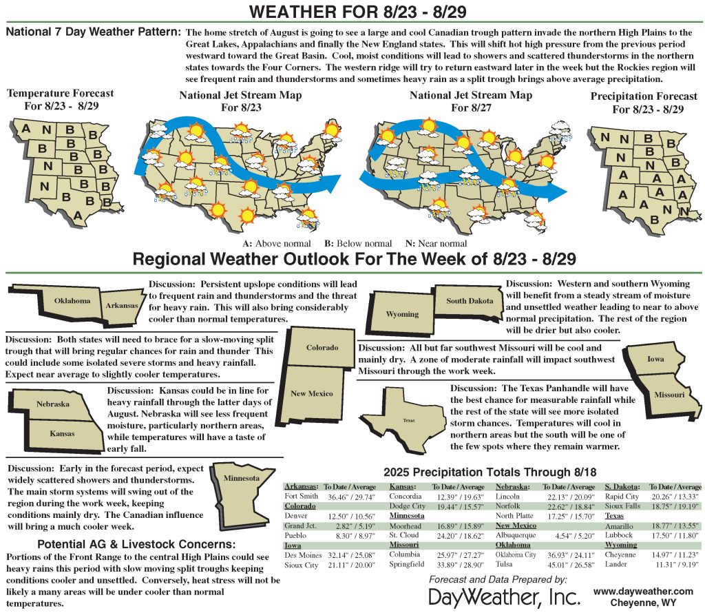
Warmer temps heat up the High Plains region
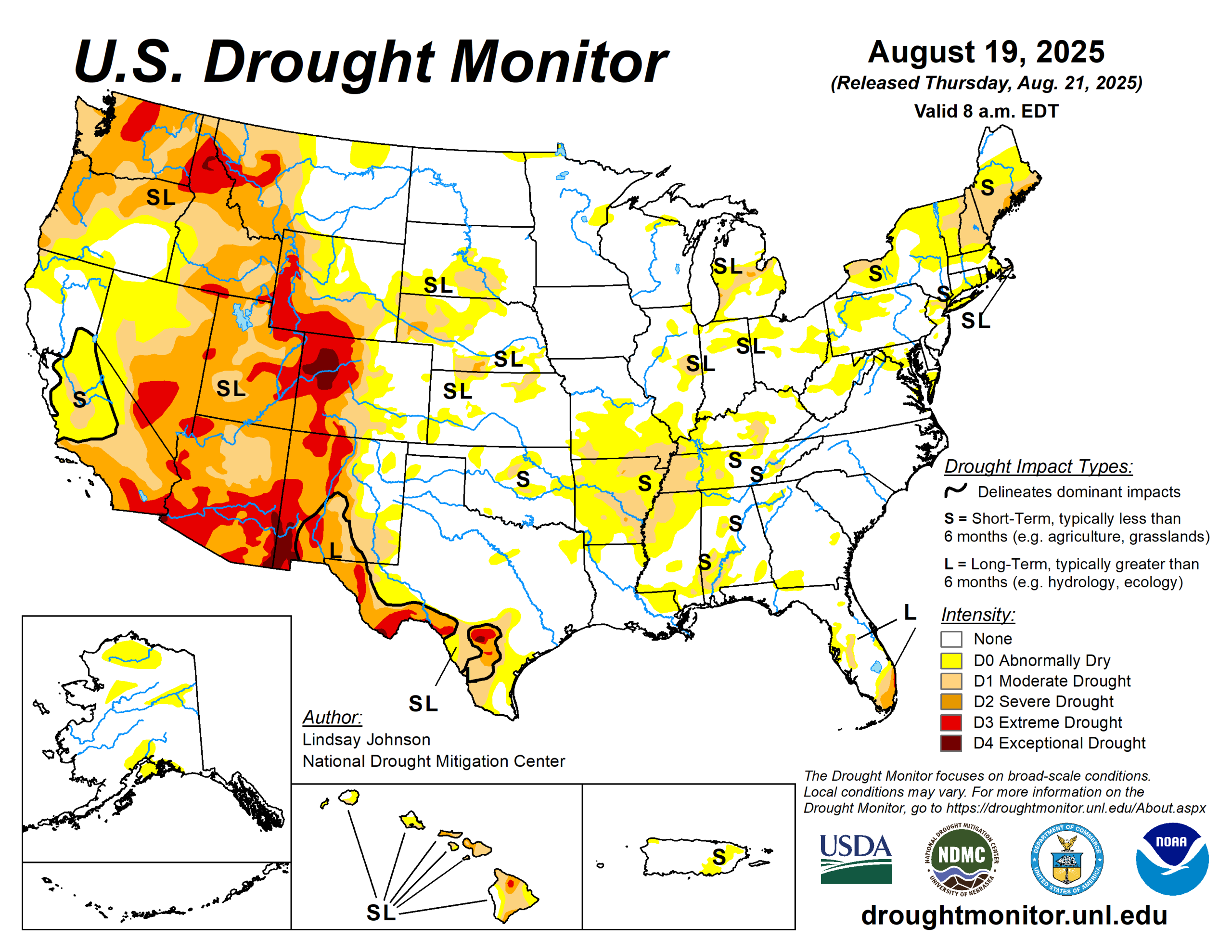
Between Aug. 13 to 19, dry and drought conditions were widespread, driven by hotter-than-average temperatures and below-normal precipitation across much of the country.
Temperatures across the country were mostly 1 to 5 degrees Fahrenheit above normal, while isolated areas of North Dakota and Minnesota saw below-normal temperatures. Areas in the central High Plains, Midwest and Arkansas saw temperatures of 5 to 10 degrees above normal.
Precipitation was mostly near to slightly below normal for much of the country.
A series of storms brought above-normal rainfall to South Dakota with areas of eastern South Dakota and southern Minnesota recording 2 to 5 inches. Storms that brought decent moisture saw improvements across the northern Intermountain West and central High Plains.
In the West, severe to exceptional drought remained widespread across New Mexico.
The High Plains also had abnormal dryness and drought intensify across Nebraska, Kansas, and the Dakotas as above-normal temperatures and limited rainfall added stress to crops and rangeland. A few localized showers, however, offered minor improvements.
In the South, scattered storms brought limited relief to parts of Texas. Flash drought conditions led to widespread intensification and expansion of abnormal dryness and moderate drought—particularly in southern Missouri and Arkansas. Areas of the Midwest that received heavy rains saw steady or improved conditions in Minnesota and Iowa.
The U.S. Drought Monitor is jointly produced by the National Drought Mitigation Center at the University of Nebraska-Lincoln, the U.S. Department of Agriculture and the National Oceanic Atmospheric Administration. (Map courtesy of NDMC.)
South
The South saw widespread drought expansion despite scattered thunderstorms that brought brief, localized relief. Texas saw some improvements due to heavy rains and flooding in south-central counties earlier in the month, which continued to ease drought there. Temperatures across the region stayed hot and humid, with heat index values topping 100 degrees in Texas and Oklahoma.
Fire danger also crept higher in Oklahoma and Texas, where persistent heat and dry rangelands created favorable conditions for grassfires. Abnormal dryness formed in the Panhandle and north-central Texas. There was widespread expansion of abnormal dryness and moderate drought across much of Oklahoma under hot, windy conditions.
Arkansas is experiencing a flash drought with conditions deteriorating quickly, with nearly the entire state now abnormally dry or worse and pockets of severe drought developing in the northeast and central counties, along with the expansion of moderate drought.
Midwest
The southern and eastern parts of the Midwest saw conditions deteriorate, with drought slowly expanding where rainfall was limited.
In Missouri, abnormal dryness and moderate drought spread in the south and central counties under hot, dry weather.
High Plains
The High Plains saw a mixed pattern of drought changes. North Dakota improved the most, as widespread storms erased nearly all dryness, leaving only a small pocket in the northeast.
South Dakota had patchy outcomes, with rainfall trimming drought in some central and southern counties while western areas remained dry. Nebraska also showed contrasts with severe dryness expanding in the Sandhills, especially in Cherry and nearby counties, while parts of the east improved after storms.
Kansas slipped slightly drier, with abnormal dryness spreading into the southwest. Conditions were most concerning in Colorado and Wyoming, where persistent heat and limited rainfall drove drought deeper. In Colorado, drought expanded along the Front Range and southwest into northern New Mexico, while Wyoming saw new extreme drought in the northwest and broader expansion of abnormally dry conditions across central counties.
These worsening conditions have fueled wildfire activity, most notably Colorado’s Lee Fire, which has already burned more than 137,000 acres, ranking among the state’s largest, while Wyoming has faced smaller but fast-moving rangeland fires.
West
Hot, dry weather dominated much of the West, fueling widespread drought expansion. New Mexico saw severe to extreme drought spread north and east as monsoon rains largely missed these areas. Drought expanded in the south and along the borders of Colorado and Wyoming.
Montana was mixed with heavy rains in the northeast allowed drought to ease, but hot, dry weather in the southwest caused drought to intensify.
Looking ahead
From Aug. 21 to 26, the heaviest precipitation is forecast along the East Coast, especially from North Carolina through the Mid-Atlantic and into southern New England, where amounts may exceed 5 inches, likely tied to a coastal storm system. Pockets of heavier rain are also expected in parts of the central Rockies, High Plains and southern Texas, with localized totals between 2 and 4 inches.
Much of the Midwest, Southeast and Southwest are forecast to receive lighter but widespread rainfall, generally between 0.5 and 2 inches.
The Climate Prediction Center’s 6- to 10-day outlook (valid Aug. 26 to 30) shows much of the central and eastern U.S. is expected to be cooler than normal, with the greatest chance for well-below-average temperatures across the Midwest. Rainfall patterns show a split across the country: wetter-than-normal conditions are likely in the central and southern Rockies, the Southwest and the central Plains.
Overall, the late-August outlook points to a cool and damp stretch for much of the central U.S., warmer weather along the West Coast and in the far South, and a drier setup in the Great Lakes and Ohio Valley.
Lindsay Johnson is with the National Drought Mitigation Center.