Southwest and parts of Plains see additional rain
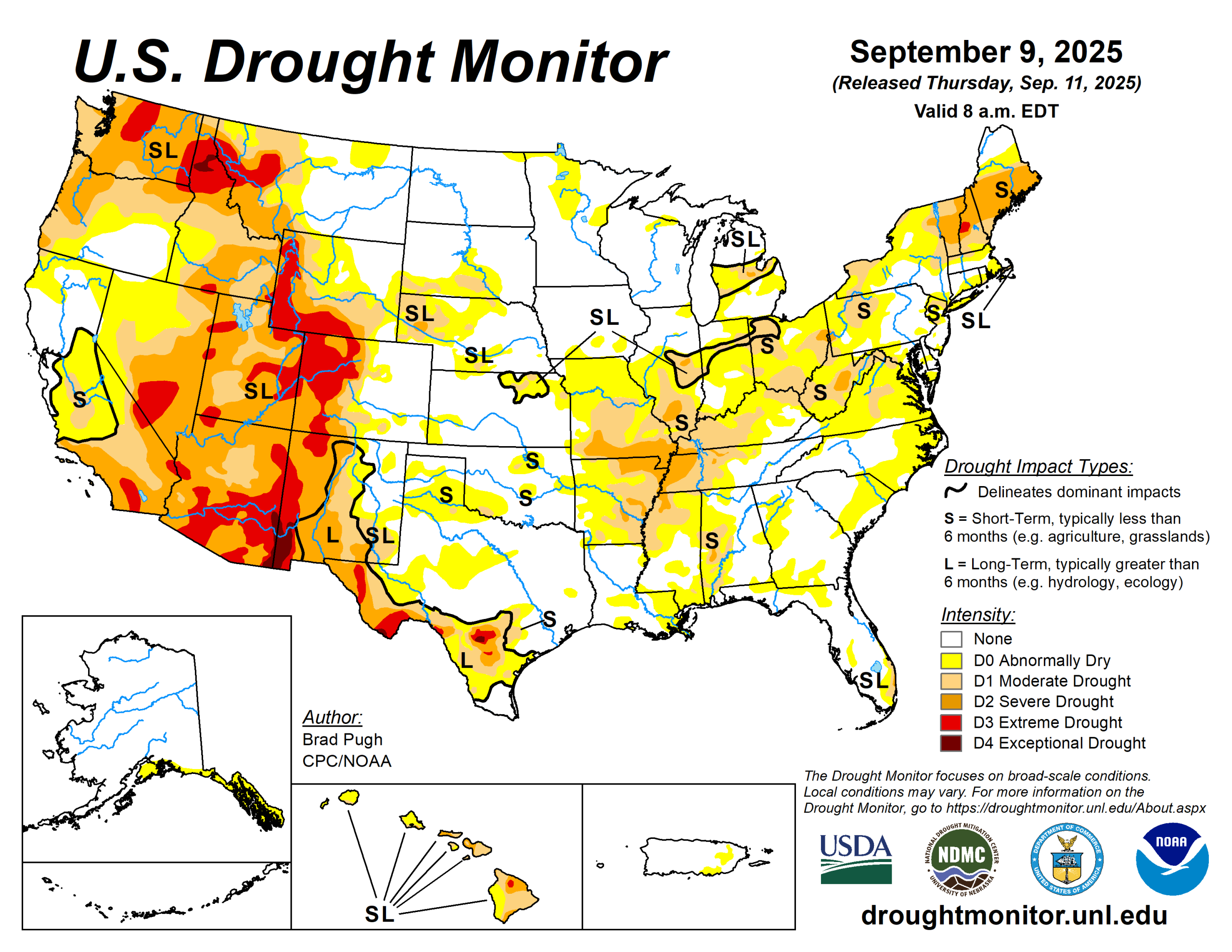
Abnormal dryness and short-term moderate to severe drought continued to expand across the Lower to Middle Mississippi Valley, Ohio Valley, Central Appalachians, Northeast, and Southeast.
However, heavy precipitation (2 inches or more) resulted in a 1-category improvement to central and eastern portions of Kentucky and Tennessee. Enhanced moisture, associated with Hurricane Lorena in the East Pacific, led to locally heavy precipitation and drought improvements to parts of the Desert Southwest.
Following a relatively wet week for this time of year, minor improvements were made to parts of Oregon. Elsewhere, little to no changes were warranted for the Pacific Northwest and California. A strong cold front for early September triggered heavy precipitation and drought improvements across New Mexico and the Rio Grande Valley of Texas.
Much of the central to northern Great Plains and Upper Mississippi Valley remained drought-free. The seven-day temperatures (Sept. 2 to 8) averaged below-normal across most of the central and eastern United States with above-normal temperatures limited to the Pacific Northwest, northern intermountain West, Great Basin, and California.
The U.S. Drought Monitor is jointly produced by the National Drought Mitigation Center at the University of Nebraska-Lincoln, the U.S. Department of Agriculture and the National Oceanic Atmospheric Administration. (Map courtesy of NDMC.)
South
Heavy precipitation (1.5 to 2 inches or more) supported a 1-category improvement to central and eastern Tennessee, while 30- to 60-day standardized precipitation index along with soil moisture indicators resulted in the expansion of severe drought across western Tennessee, northern Mississippi, and northeastern Arkansas. Increasing 30- to 60-day precipitation deficits supported extending abnormal dryness south to the Mississippi Gulf Coast.
For the long-term drought areas designated in Texas, a round of heavy precipitation (more than 1.5 inches) this past week resulted in 1-category improvements. Based on the 120-day SPI and NASA SPoRT soil moisture, abnormal dryness was expanded across southwestern Oklahoma with the addition of a small moderate drought area. A 30- to 60-day SPIs along with declining soil moisture supported an increasing coverage of D0 across the Texas Panhandle and Edwards Plateau.
Midwest
Widespread 1-category degradations were warranted for much of central and southern Missouri based on 30 to 60-day SPI, soil moisture, National Drought Mitigation Center blends, and impact reports. Poor pasture conditions, low farm pond levels, and increasing stress on soybeans have been reported across southwestern and south-central Missouri.
Short-term moderate drought continues to expand across Illinois, eastern Indiana, Ohio, and western Kentucky due to a multi-week period of below-normal precipitation.
High Plains
Heavy precipitation (more than 2 inches) occurred in areas of central Kansas and significant precipitation (1.5 to inches) led to a minor decrease in abnormal dryness in southwestern Kansas.
Conversely, a slight increase in abnormal dryness and moderate drought was made to eastern Kansas. Significant precipitation (more than 0.5 inches and locally 2 to 3 inches) supported improvements across southern Colorado, while worsening SPIs led to a slight expansion of severe to extreme drought for northern Colorado. Much of the Dakotas, Nebraska and eastern Wyoming remain drought-free.
West
Heavy precipitation (1 to 2.5 inches) supported a decrease in severe to extreme drought around the Albuquerque, Santa Fe and Las Cruces areas of New Mexico. In addition, NDMC’s long-term drought blend was used as guidance.
A favorable response to heavy precipitation (2 to 2.5 inches) two weeks ago led to the removal of extreme drought in southwestern Montana. Farther to the north, a 1-category degradation was made in northwestern Montana after a reassessment of longer-term metrics including the NDMC blend.
Looking ahead
The drier pattern is likely to persist across much of the eastern and central U.S. through Sept. 15. Along with the continued dryness dating back to August, a transition to warmer-than-normal temperatures is underway throughout the central U.S. and summer-like heat is forecast to expand east across the Mississippi and Ohio Valleys.
From Sept. 13 to 15, maximum temperatures are expected to reach the upper 90s to near 100 degrees Fahrenheit from St Louis south to Memphis. Another week of heavy rainfall is forecast to affect the southern third of the Florida Peninsula and portions of New Mexico. Showers and thundershowers will shift eastward from Oregon and the northern intermountain West to the northern Great Plains.
The Climate Prediction Center’s 6- to 10-day outlook (valid Sept. 16 to 20) favors above-normal temperatures for nearly the entire lower 48 states. Above-normal precipitation is more likely for the northern to central Great Plains, the Rockies and Southwest.
Brad Pugh is with the National Oceanic Atmospheric Administration and Climate Prediction Center.