Hit-and-miss rain story late of late summer
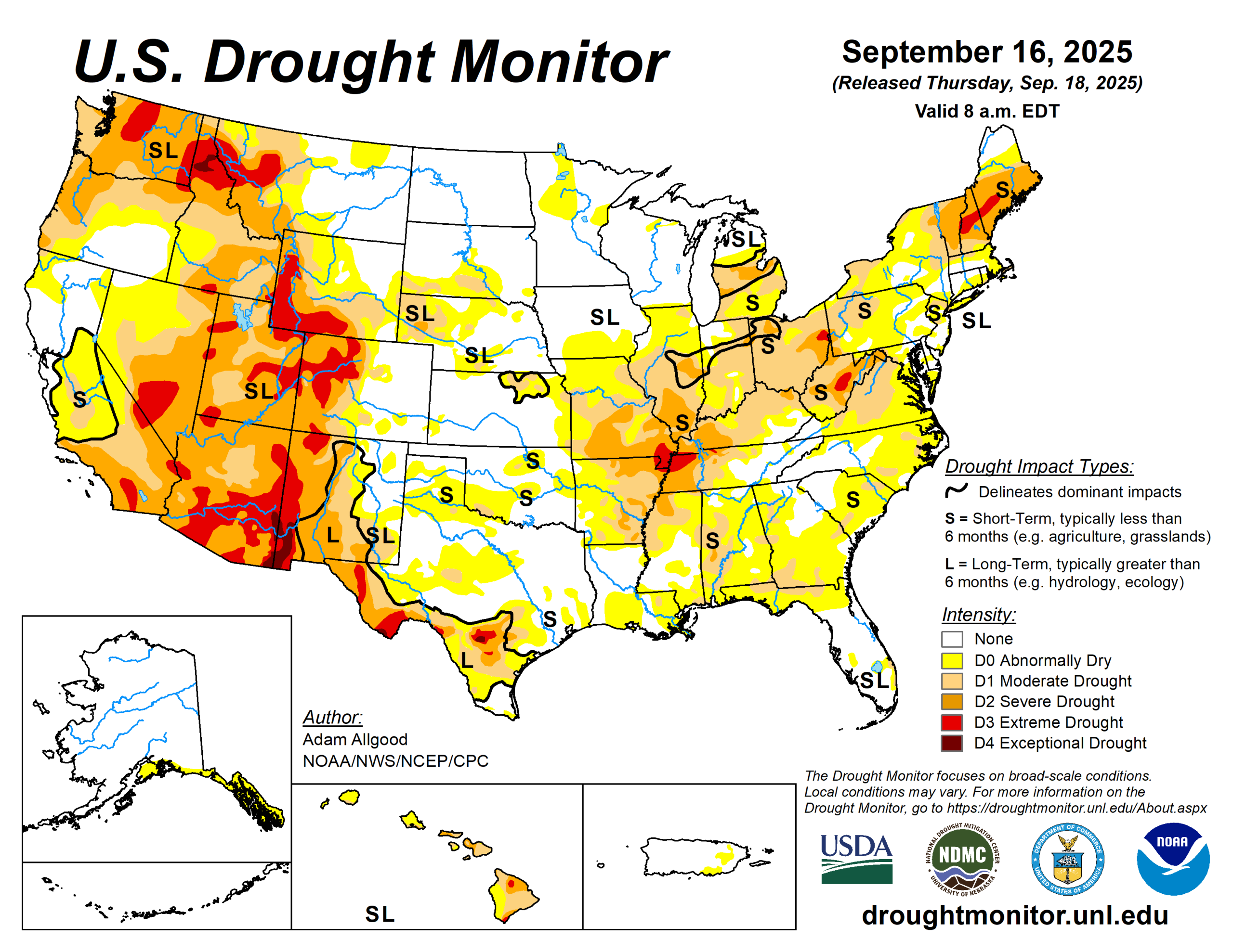
Another week of scant rainfall led to widespread expansion of abnormal dryness and moderate to severe drought across the Midwest, Southeast and Northeast regions.
Extreme drought was introduced near the confluence of the Mississippi and Ohio Rivers, as well as eastern Ohio and portions of West Virginia. Some expansion of drought and abnormal dryness also occurred across portions of Texas, Oklahoma, and the eastern Plains, while moderate to heavy precipitation brought 1-category improvements to localized areas in western Texas, northward through western Nebraska.
Along the Rockies, above-average precipitation yielded fairly widespread 1-category improvements. Above-normal rainfall for the time of year fell across northern California and the Intermountain West, resulting in modest 1-category improvements ahead of the new water year.
Enhanced monsoonal moisture was focused across New Mexico and southeastern Arizona, sparking a 1-category reduction from exceptional drought conditions in the area. Seven-day temperature anomalies were above-normal across the Northern Tier and Midwest, exacerbating the rapid onset of impacts, while below-normal temperatures across the east helped to slow the deterioration somewhat.
The U.S. Drought Monitor is jointly produced by the National Drought Mitigation Center at the University of Nebraska-Lincoln, the U.S. Department of Agriculture and the National Oceanic Atmospheric Administration. (Map courtesy of NDMC.)
South
Spotty convection late in the week brought localized rainfall to portions of Arkansas, but accumulations were generally insufficient to change existing drought conditions.
More widespread rainfall, some locally heavy, overspread western and northern Texas, western Oklahoma, and far southern Texas. Most of this precipitation accumulated outside of existing areas of abnormal dryness or drought, though small 1-category improvements occurred across portions of western Texas, and the rainfall helped prevent further degradations.
Drier conditions and seasonably warm temperatures warranted some degradations across central, southern, and eastern Texas, as well as the eastern two thirds of Oklahoma.
Midwest
Generally wet conditions were observed across the upper Midwest, including Minnesota and northern Iowa. A 1-category improvement occurred across northern Minnesota while abnormal dryness expanded across western Minnesota, which missed out on the rainfall during a week of above-normal temperatures.
In contrast, rapidly worsening impacts, persistent subnormal rainfall, and increasingly poor 30 to 90-day standard precipitation index values warranted widespread degradations across the remainder of the Great Lakes region and the Ohio Valley.
Moderate to severe drought expanded to cover much of southern Illinois, Indiana, and Ohio.
High Plains
Widespread rainfall overspread western Kansas, Nebraska, western South Dakota, and North Dakota, resulting in modest reductions of abnormal dryness and moderate drought across western Kansas and central Nebraska.
The highest rainfall totals fell across the Dakotas in regions that are currently drought-free. Drier conditions and warm temperatures prevailed across portions of eastern Kansas and northeastern Nebraska, with declining SPI values warranting some expansion of abnormal dryness.
Across Colorado and Wyoming, widespread precipitation fell across the mountainous regions, prompting some drought relief across northwestern Wyoming and much of western Colorado, including reductions in coverage of extreme to severe drought conditions.
West
Fairly widespread early season precipitation prompted modest reductions to drought coverage across the Northwest, where widespread severe to extreme drought conditions remain entrenched.
While much above normal for the time of year, accumulations were modest compared to amounts that can occur during the core weeks of the wet season during the winter.
Across the Southwest, robust monsoonal moisture warranted a small reduction in coverage of exceptional drought across southeastern Arizona and southwestern New Mexico.
Looking ahead
A frontal system is forecast to help generate widespread precipitation across the Plains states and portions of the Midwest along and west of the Mississippi River during the upcoming week.
This rainfall has a potential to bring much-needed relief to regions that have experienced rapidly worsening drought conditions. In contrast, lighter rainfall is forecast for the Ohio Valley and East, which, coupled with warmer temperatures, may further exacerbate conditions in areas experiencing rapid drought onset.
Wet conditions early in the week across the Southwest will give way to a drier pattern overall through the end of the week.
The Climate Prediction Center’s six- to-10-day outlook, for Sept. 23 to 27, favors above-normal temperatures across the entire contiguous United States, with the highest probabilities extending across the north-central states. Above-normal precipitation is favored across the Intermountain West, and across much of Texas. In contrast, below-normal precipitation is favored along the Rockies and eastward across much of the Great Plains, upper-Midwest, and the western Great Lakes region.
Adam Allgood is with the National Oceanic Atmospheric Administration, National Weather Service, National Centers for Environmental Prediction, and Climate Prediction Center.