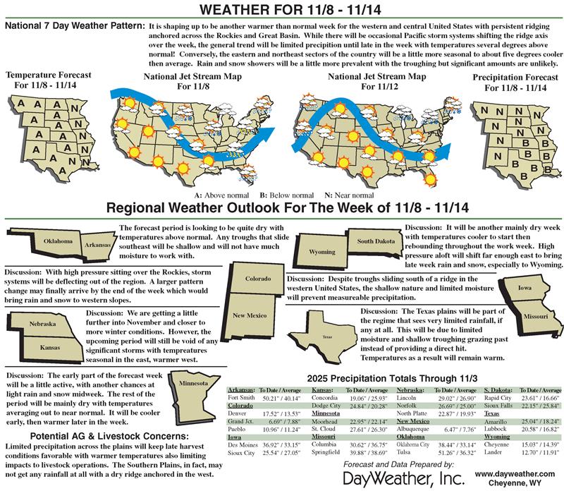
Low-precipitation pattern hits High Plains region
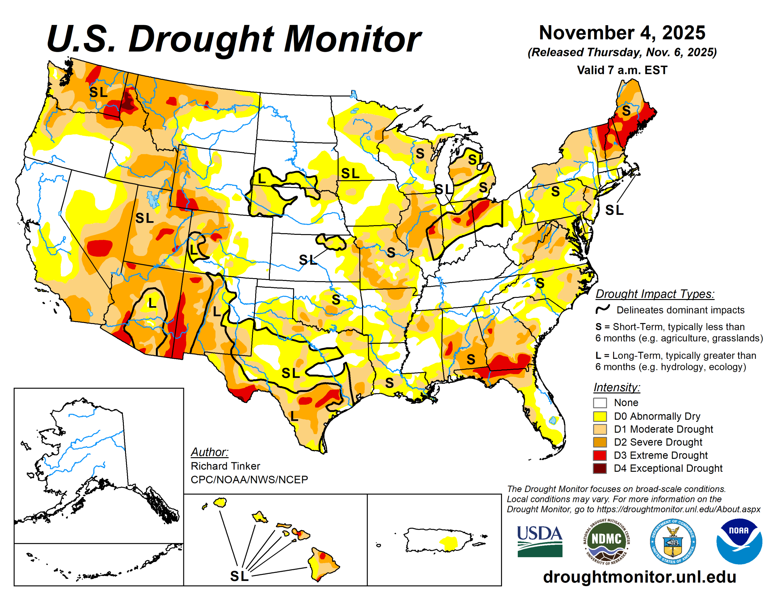
After the prior week’s beneficial precipitation, low precipitation totals this past week allowed for broad areas of intensification or re-intensification of dryness and drought over parts of the High Plains.
Impacts were felt in most of Texas, southern Oklahoma, the northern Great Lakes, parts of the northern Great Plains, portions of the central High Plains and north-central Montana,
Meanwhile, heavy precipitation again doused the Pacific Northwest, especially across the northern half of the Cascades and along the Washington and northern Oregon Coast. Between 6 and 10 inches of precipitation fell on most of northwestern Washington, and 6 to 8 inches fell on most of the northern Washington Cascades and a few areas near the Washington/Oregon border and along the northwestern Oregon Coast.
From central Oregon northward, over 3 inches fell on the Cascades and coastal areas while 1.5 to 3 inches fell on other locations there from the Cascade Foothills to the Pacific Ocean. Farther east, locally heavy precipitation (1 to locally approaching 4 inches) was observed in northwestern Montana and northern Idaho. Other locations from the Great Plains westward to the Pacific Ocean were much drier, with most locations recording no measurable precipitation.
The U.S. Drought Monitor is jointly produced by the National Drought Mitigation Center at the University of Nebraska-Lincoln, the U.S. Department of Agriculture and the National Oceanic Atmospheric Administration. (Map courtesy of NDMC.)
South
Moderate to heavy rain (1 to 3 inches) doused Tennessee, portions of Arkansas, and some adjacent areas. Dryness and drought over western Tennessee and much of Arkansas eased.
Most other locations across Tennessee, Arkansas, eastern Oklahoma, and northern Mississippi reported several tenths of an inch of rain, and similar totals fell on isolated areas across southern Mississippi, Louisiana and coastal Texas.
The remainder of the region, including most of Texas and Oklahoma, observed no measurable rain. After beneficial precipitation the prior week, the precipitation-free week allowed dryness and drought to re-intensify or expand over large parts of Texas and southern Oklahoma.
After drought coverage (D1+) declined to about one-third of the state the prior week, coverage increased to over 45%, which is the greatest extent since early May. Areas of late-season crop stress and some die-off has been reported across Oklahoma and Texas over the past few weeks.
Midwest
A few tenths to a little more than an inch was observed over southern sections of Illinois and Indiana, in a swath from Missouri northward through interior Minnesota, and in the northern Great Lakes region. Little or no precipitation was observed over the remainder of the Great Lakes region, eastern Minnesota, central and northern sections of Indiana and Illinois, and northwestern Ohio.
Predictably, this precipitation pattern resulted in continued improvement near the Ohio River and across most of Ohio while the dry week engendered persistence or intensification across the northern and central tier of the Region. In particular, increasing 60- and 90-day precipitation deficits prompted significant expansion of moderate drought across east-central Minnesota. As a result, even though coverage by some degree of dryness or drought (D0+) dropped from 68.8 to 65.1% last week, drought coverage (D1+) actually ticked up slightly from 33.4 to 34.8%.
High Plains
The High Plains region is currently the region least-affected by dryness and drought even though coverage in sum increased slightly this past week when most of the region reported a few tenths of an inch of precipitation at best.
Measurable totals were restricted to eastern Kansas and southeastern Nebraska. The dry week induced a few areas of deterioration, but even so, less than 39% of the region is experiencing some degree of dryness, and only 17.8% is enduring drought. Precipitation deficits on most time frames crept upward region-wide, but areas of deterioration were relatively limited given the relatively low natural and human water demand this time of year.
West
Several inches of precipitation pelted central and northern sections of the Cascades and coastal Pacific Northwest, and 1- to 3-inch totals were common across northwestern Montana and northern Idaho, as well as the lower elevations in the Pacific Northwest between the coast and the Cascades.
Several tenths of an inch of precipitation were reported farther south along the West Coast and in the lower elevations of the northern Intermountain West, but most of the West region received no measurable precipitation. This prompted areas of intensification in north-central Montana and southeastern New Mexico while the heavy precipitation led to areas of improvement in the Pacific Northwest.
But given how early it is in the wet season and that normals are ramping upward fairly quickly there, improvement in dryness and drought was not as widespread as one might assume. Montana reported intensification in north-central parts of the state, but a little improvement farther west. According to the U.S. Geological Survey, flows along numerous rivers in the West remain very low. On the Missouri River at Great Falls, Montana, in early November, streamflow was observed at 3,620 cubic feet per second, well below the mean for the date since the turn of the century (4,934 cubic feet per second, ranging from 3,880 in 2021 up to 6,470 in 2010). On the Firehole River, near West Yellowstone, MT, streamflow was 212 cubic feet per second in early November, below the 2002-2024 mean of 272 for similar dates, which ranged from 236 in 2022 to 318 in 2008. These amounts are up slightly since late summer. In late August, a field measurement of 193 cubic feet per second was bested only by 192 in early August 2016.
Looking ahead
Over the next five days (through Nov. 10), totals ranging from a few tenths of an inch to about an inch of rain are anticipated across the northern Intermountain West. That is also forecast in elevations of western Wyoming, isolated parts of the northern Great Plains and portions of the Midwest.
Temperatures are forecast to average warmer than normal in the West and cooler than normal in the East. A shot of cold air – the coldest of the season so far – should push through the East early next week. It will not linger for long, but on one or two nights temperatures could approach freezing as far south as the central Gulf Coast, and readings in the 50s degrees Fahrenheit may reach into the southern Florida Peninsula.
For the five days overall, high temperatures are expected to average 5 to 8 degrees below normal from the Great Lakes and Midwest southeastward into northern Florida. In contrast, daily highs from the High Plains to the Pacific Coast should average 5 to 12 degrees above normal, with the largest departures expected in parts of the Great Basin, near the California/Oregon border, and over the northernmost Rockies.
The 6- to 10-day outlook from the Climate Prediction Center for Nov. 11 to 15 favors subnormal precipitation for most areas from the Great Plains to the Atlantic Coast, except along the northern tier of the region.
Abnormally wet weather is favored from the High Plains to the Pacific Coast, with chances for unusually heavy precipitation exceeding 60% across central and southwestern California. From roughly the Mississippi River to the Pacific Coast, warmer than normal weather is favored, with odds topping 70% across a broad area covering most of the central and southern Rockies and High Plains.
Richard Tinker is with National Oceanic Atmospheric Administration, National Weather Service, National Centers for Environmental Prediction, and Climate Prediction Center.