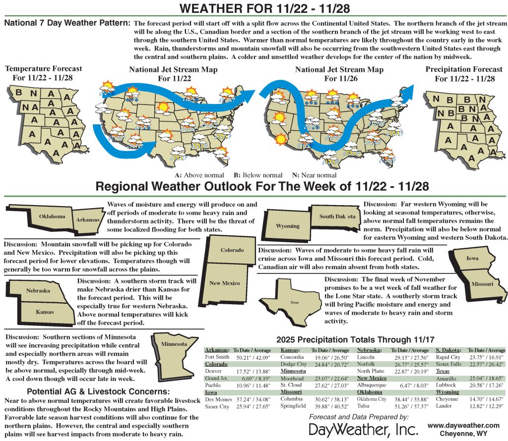
Dry weather dominated much of the High Plains
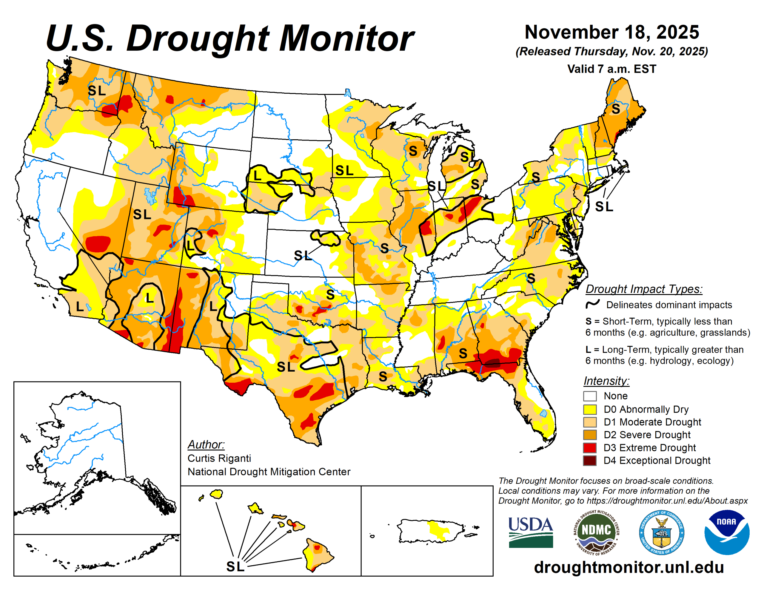
Dry weather covered most of the central and eastern United States this week, with a few localized areas of heavier precipitation falling in the Northeast and parts of eastern South Dakota.
In the West, heavy rain and snow was widespread, especially in parts of southern Nevada, southern and coastal California, the Sierra Nevada, the Pacific Northwest and northwest Montana. Temperatures west of the Mississippi River were mostly warmer than normal, especially in Montana and Wyoming, where temperatures of 12 or more degrees Fahrenheit above normal were common.
East of the Mississippi River, near- or below-normal temperatures were widespread, especially in southern Georgia and Florida, where temperatures were 6 to 12 degrees colder than normal. Given the wetter weather recently, improvements continued in parts of the Northeast, where streamflow and soil moisture continued to recover and precipitation deficits lessened.
Improvements were also widespread in California and Washington, where recent precipitation has cut into or erased precipitation deficits and boosted soil moisture and streamflow. Degradations were common in Oklahoma, Texas, Louisiana, Florida, Georgia, and North Carolina, where short-term precipitation deficits grew.
Widespread degradation also occurred in parts of Nebraska, central and northeast Montana and the western Great Lakes area, as primarily short-term dryness intensified in each of these areas.
The U.S. Drought Monitor is jointly produced by the National Drought Mitigation Center at the University of Nebraska-Lincoln, the U.S. Department of Agriculture and the National Oceanic Atmospheric Administration. (Map courtesy of NDMC.)
South
Dry weather occurred across nearly the entire South region, which led to widespread degradations in conditions in some states. Warmer-than-normal temperatures occurred in parts of Texas and Oklahoma and some locales in Arkansas, while near- or below-normal temperatures were more common elsewhere.
In the Texas Panhandle and southwest parts of the Lone Star State, temperatures of at least 9 degrees above normal were common. South of Oklahoma City, extreme drought developed where ponds dried up amid large short-term precipitation deficits and above-normal evaporative demand. Degradations occurred across large parts of southern Oklahoma where short-term precipitation deficits continued amid above-normal temperatures.
A mix of short- and long-term precipitation deficits and warm temperatures led to degradations in southern Texas, while conditions also degraded in parts of north Texas and the Texas Panhandle during recent dry and warm weather.
Short-term precipitation deficits also grew in much of northeast Texas, Louisiana, southwest Arkansas and southern Mississippi, leading to degrading conditions. Streamflow and soil moisture levels also were low in some areas that worsened.
Midwest
This week, scattered precipitation fell in parts of central and eastern Missouri, Illinois, southern Indiana, northern and eastern Iowa and the eastern Upper Peninsula of Michigan. Otherwise, primarily dry weather occurred.
In Decatur, Illinois, stage one water restrictions began, and severe and extreme drought expanded in the area surrounding Champaign-Urbana as shortages in soil moisture and precipitation intensified again. From northeast Iowa into the western Great Lakes area, moderate and severe drought and abnormal dryness developed or expanded.
Streamflow and soil moisture continued to struggle amid growing precipitation deficits in parts of Missouri, where abnormal dryness and moderate and severe drought locally expanded.
Severe drought now covers the entire Kansas City area, where soil moisture levels continue to be low amid a very dry late summer and autumn. Warmer-than-normal temperatures occurred in the western reaches of the Midwest (primarily along and west of the Mississippi River).
High Plains
Primarily dry and warmer-than-normal weather occurred in the High Plains region this week, with the exceptions of east-central South Dakota and some high-elevation areas of Colorado and Wyoming.\
Temperatures in Wyoming and parts of eastern Colorado were 12 or more degrees above normal this week, while eastern parts of the Dakotas, Nebraska and Kansas were mostly 3 to 9 degrees warmer than normal. Short-term precipitation deficits and decreasing soil moisture in some areas led to expansions and development of abnormal dryness and moderate drought in parts of eastern and central Nebraska.
In western Nebraska, abnormal dryness and moderate drought expanded under similar conditions, while severe drought also developed where more substantial longer-term precipitation deficits were taking place.
In and near the Kansas City area, moderate and severe drought locally expanded where soil moisture levels decreased and short-term precipitation shortfalls grew. Abnormal dryness expanded across the southeast Colorado plains where short-term precipitation deficits grew, while moderate drought filled in in northwest Colorado where short-term dryness aligned with long-term precipitation deficits.
West
Widespread heavy precipitation fell in northwest Montana, including reports of more than 5 inches of rain. Soil moisture levels increased across California amid the heavy precipitation.
Conditions also improved after recent precipitation cut into precipitation deficits and locally improved soil moisture, groundwater and streamflow in northwest Montana. Despite the widespread precipitation, weekly temperature anomalies were warm across the entire West. Compared to normal, Montana and Idaho were generally the warmest, with parts of Montana and southern Idaho finishing the week 12 degrees or more warmer than normal.
In the plains of central and northeast Montana, moderate and severe drought and abnormal dryness quickly worsened amid warmer-than-normal temperatures and drier weather. In these areas, streamflow locally decreased amid growing soil moisture and short-term precipitation deficits.
Looking ahead
From the evening of Nov. 19 to 24, the National Weather Service Weather Prediction Center is forecasting a large area to receive near or over 1 inch of precipitation including northeast Colorado and south to northwest Louisiana and much of Oklahoma and Texas (excluding the Southwest). Precipitation amounts of at least two-thirds of an inche is forecast for New Mexico.
Mostly dry weather is forecast across the northern Great Plains.
For Nov. 25 to 29, the NWS Climate Prediction Center forecast favors above-normal precipitation across parts of the northern, central and eastern U.S.
The highest confidence areas for above-normal precipitation include the northern Great Plains and the Southeast. Drier-than-normal weather is favored in the Southwest U.S., especially in coastal California, southeast Arizona, southern New Mexico and southwest Texas. The forecast favors colder-than-normal temperatures from northern Washington east to Lake Superior and southward through the central Great Plains. In the West, warmer-than-normal temperatures are likelier from central Oregon southward along the Pacific Coast and eastward to near the Continental Divide.
The forecast favors warmer-than-normal temperatures in areas from the Gulf Coast to the Mid-Atlantic, with the highest confidence for warmth centered over the Southeast.
Curtis Riganti is with the National Drought Mitigation Center.