Temps and precipitation varied sharply across country
Temperature and precipitation patterns varied sharply across the country this past week.
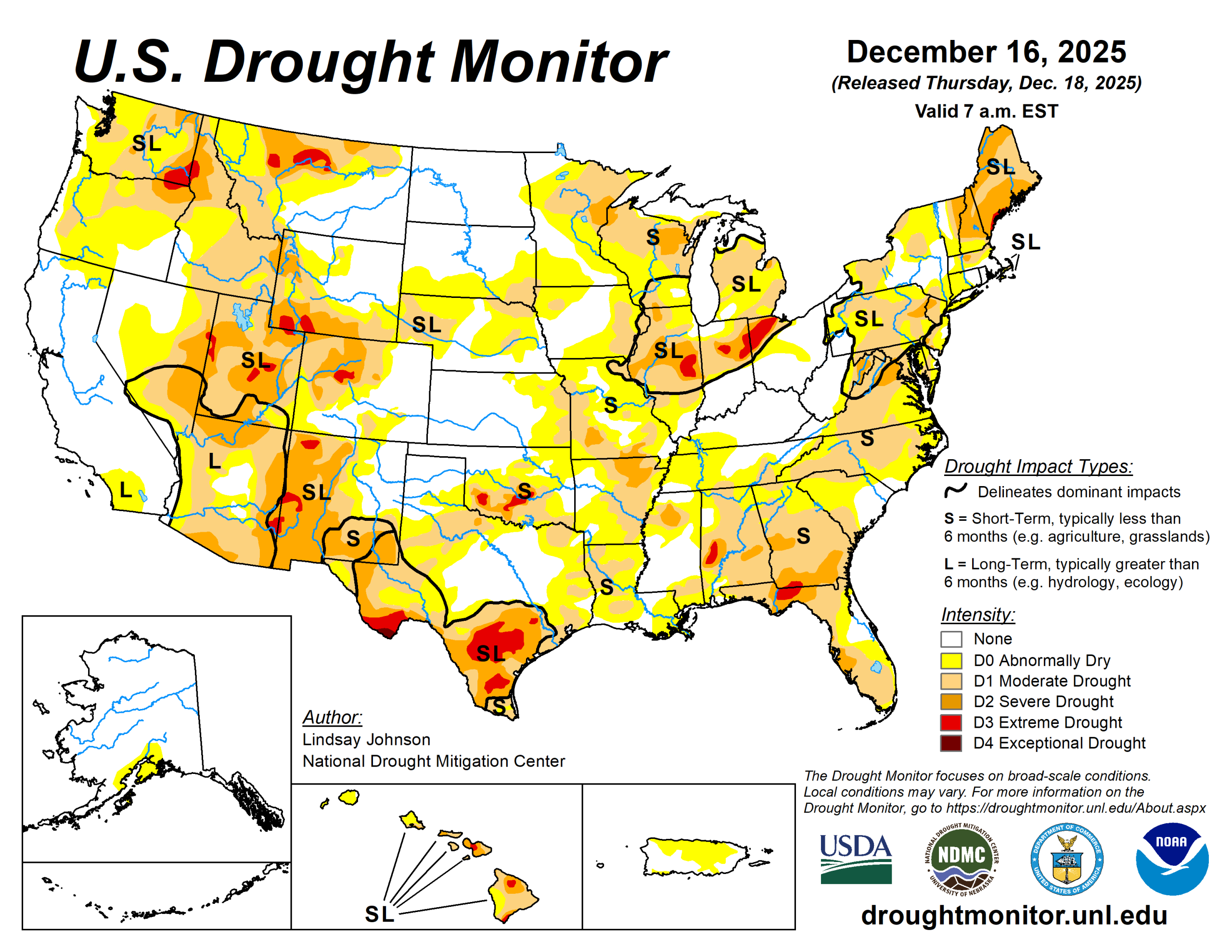
Temperatures were generally warmer in the West and colder in the East, with much of the Cascades and Rocky Mountains running well above normal while the Midwest experienced much colder-than-normal conditions. Multiple Pacific storm systems brought widespread precipitation to the Pacific Northwest and northern Rockies, falling as rain at lower elevations and snow in the mountains. Despite recent snowfall, snowpack remains below normal for mid-December.
East of the Rockies, precipitation was more limited and uneven, and where it did occur across the Northern Plains and Midwest, it often fell as snow. As a result, drought conditions improved mainly across parts of the Pacific Northwest and northern Rockies. Additional localized improvements occurred in parts of the Southeast, where lingering benefits from rainfall in prior weeks continued to support soil moisture and streamflows.
In contrast, areas farther south and east that missed meaningful precipitation saw conditions persist or worsen. Across portions of the southern Plains, lower Mississippi Valley, Ohio Valley, Mid-Atlantic, and Northeast, continued precipitation deficits and declining streamflows led to degradations. In the Midwest, colder temperatures limited precipitation to fall as snow, slowing hydrologic response and resulting in mostly localized changes.
The U.S. Drought Monitor is jointly produced by the National Drought Mitigation Center at the University of Nebraska-Lincoln, the U.S. Department of Agriculture and the National Oceanic Atmospheric Administration. (Map courtesy of NDMC.)
South
Drought conditions across the South generally worsened as limited precipitation did little to improve the growing moisture deficits.
In Texas and Oklahoma, ongoing precipitation deficits led to further expansion of abnormally dry (D0) and moderate drought (D1) conditions. In south-central Texas, longer-term hydrologic stress continued and intensified with the expansion of severe (D2) and extreme drought (D3). Across Arkansas, despite cooler-than-normal temperatures, dry conditions continued to worsen, with growing precipitation deficits, drying soils, and decreasing streamflows leading to the expansion of abnormal dryness (D0) and moderate drought (D1).
Midwest
The central and southern Midwest saw mixed and localized changes, shaped by uneven precipitation and below-normal temperatures, particularly across the northern part of the region where conditions largely remained unchanged.
Much of the recent precipitation fell as a mix of rain and snow. In east-central Iowa, one-class improvements were made where repeated precipitation helped ease short-term dryness. In Illinois and Missouri, longer-term precipitation deficits and low streamflows persisted, and recent precipitation was insufficient to improve conditions, leading to expansions of abnormal dryness (D0) and moderate drought (D1) along the Missouri–Illinois border.
In southwestern Missouri, one-class degradations reflected continued hydrologic stress.
High Plains
The High Plains remained largely unchanged.
Areas of less than an inch of precipitation fell across some areas of the Dakotas and northeastern Wyoming. In east-central South Dakota, this precipitation led to minor improvements with the removal of some abnormal dryness (D0). Nebraska, Colorado, and most of Kansas remained unchanged.
In southeastern Kansas along the Kansas-Missouri border, hydrologic deficits led to further deterioration and the expansion of moderate drought (D1). In southeastern Wyoming, frequent strong winds and above-normal temperatures combined with continued lack of precipitation contributed to further degradation and the expansion of moderate drought (D1).
West
Across the West, drought changes were mainly determined by precipitation.
In Washington and northern Oregon, multiple Pacific storm systems, associated with atmospheric river moisture, brought widespread precipitation to the Pacific Northwest. Precipitation fell mainly as rain at lower elevations and snow in the mountains, contributing to ongoing flooding in parts of western Washington and supporting widespread one-class improvements along the coast and nearby interior areas.
In the northern Rockies, repeated precipitation supported one-class improvements across northern Idaho and northwestern Montana. Lower elevations experienced rain or mixed precipitation, while higher elevations received snow, leading to snow water equivalent improvements in northern and central Idaho and western Montana. Snowpack across western and central Montana showed the greatest improvement, with SWE near or above 90% of normal for this time of year. Farther east and south across central and western Montana, more widespread precipitation supported a swath of one-class improvements.
Across the central Rocky Mountains of Wyoming and Colorado, conditions were more mixed. Portions of the north-central Rockies received enough snowfall to lead to localized improvements, with SWE in some headwater areas approaching near-normal early-season levels.
Elsewhere, continued warmth and limited snowfall hindered snowpack development, allowing drought conditions to persist or worsen in some mountain and adjacent areas. In the Southwest, localized changes were made in New Mexico, with improvements in central New Mexico where longer-term precipitation from earlier periods continued show hydrologic improvement, while precipitation deficits led to the expansion of moderate drought (D1) in the southeast part of the state.
Looking ahead
According to the National Weather Service’s 5-day (Dec. 18 to 23) quantitative precipitation forecast, the heaviest precipitation is forecast across the West, particularly along the Pacific Northwest coast and into northern California, where widespread totals may exceed 5 inches in some areas.
Additional moderate to heavy precipitation is expected across the Cascades and into parts of the northern Rockies, with totals generally ranging from 1 to 4 inches. Lighter but still notable precipitation is forecast to extend eastward into portions of the central Rockies and the Northern Plains. Across the central and eastern United States, precipitation is expected to be more scattered and generally lighter.
Portions of the Midwest may receive light to moderate precipitation, generally ranging from 0.5 to 2 inches.
The Climate Prediction Center’s 6- to 10-day temperature outlook (Dec. 22 to 26) shows an increased likelihood of above-normal temperatures across much of the central and southern U.S., extending from the West Coast through the Plains and into the Southeast. The highest probabilities for above-normal temperatures are centered over the Southern Plains and Southwest, with much of the interior West, Rockies, and central Plains also favored to be warmer than normal.
In terms of precipitation, the outlook indicates an increased likelihood of above-normal precipitation across much of the West, including the northern Rockies. Near- to above-normal precipitation probabilities also extend into parts of the interior West. In contrast, below-normal precipitation is favored across much of the central Plains.
Lindsay Johnson is with the National Drought Mitigation Center.