Patchy downpours helped alleviate drought stress in High Plains
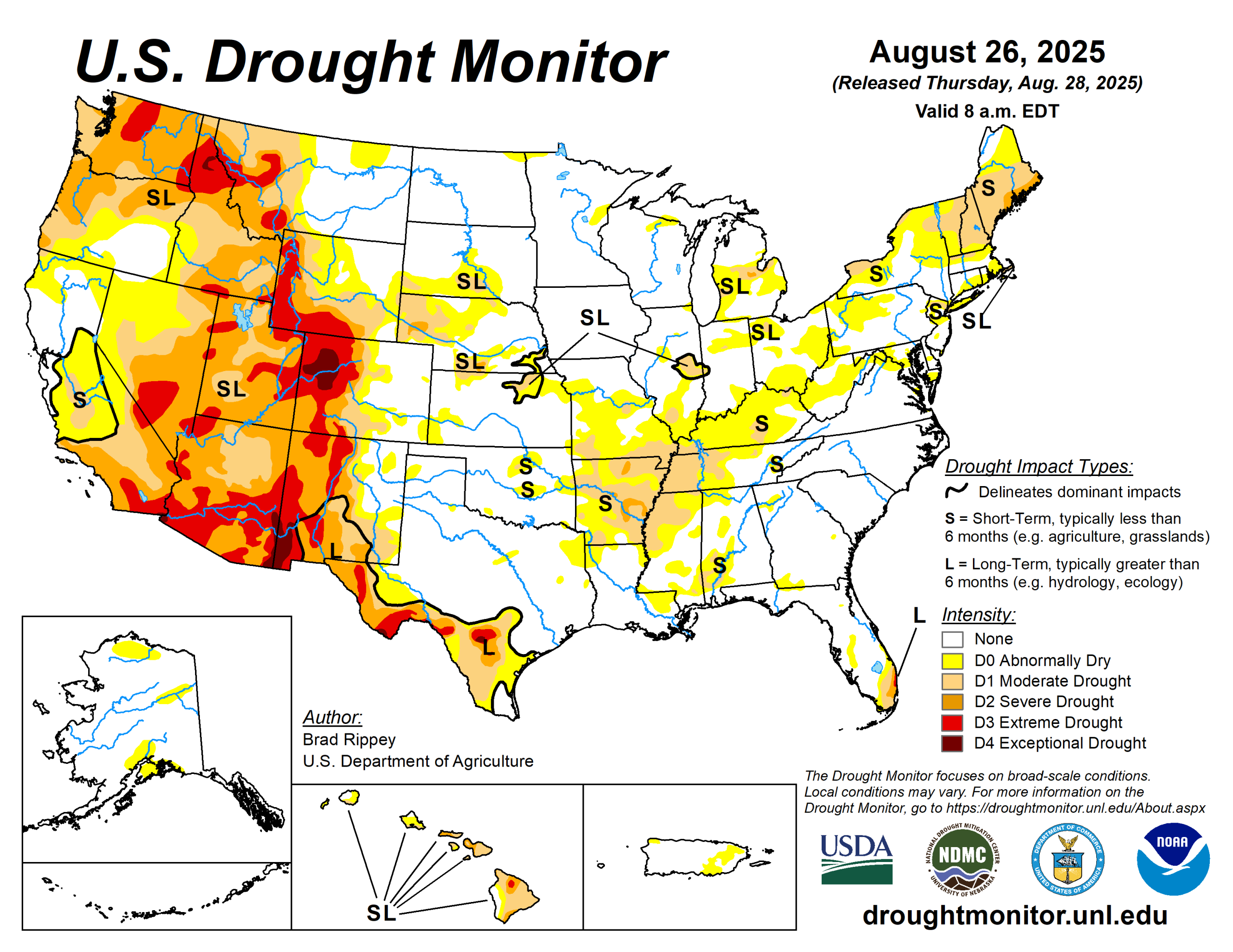
Patchy downpours maintained adequate to locally excessive soil moisture in much of the upper Midwest, while locally heavy showers dotted the central and southern Plains and the lower Southeast.
However, mostly dry weather in many other areas across the central and eastern United States led to declining topsoil moisture reserves, especially where combined with late-summer heat. Cooler air arrived, however, late in the drought-monitoring period, starting in the North and soon reaching all areas east of the Rockies, but the northern High Plains and the Deep South.
Meanwhile in the West, hot, mostly dry weather prevailed until late in the period, when shower activity increased and began to spread northward.
The U.S. Drought Monitor is jointly produced by the National Drought Mitigation Center at the University of Nebraska-Lincoln, the U.S. Department of Agriculture and the National Oceanic Atmospheric Administration. (Map courtesy of NDMC.)
South
Flash-drought conditions across the mid-South contrasted with the arrival of heavy rain in Oklahoma and neighboring areas.
On Aug. 24, prior to the heavy rain, statewide topsoil moisture was rated 60% very short to short in Texas, along with 53% in Oklahoma. Portions of central and northwestern Oklahoma received 3 to 6 inches of rain during the drought-monitoring period.
Meanwhile, topsoil moisture was rated more than one-half very short to short on Aug. 24 in Arkansas (92. Aside from west-central Arkansas, where some heavy rain fell, conditions generally worsened with broad expansion of abnormal dryness (D0) and moderate to severe drought (D1 to D2).
Midwest
Continuing a recent theme, drier-than-normal weather in the southern and eastern Corn Belt generally contrasted with locally heavy showers (and ample soil moisture reserves) farther north and west.
Despite a turn toward cooler weather, coverage of abnormal dryness (D0) and moderate drought (D1) broadly increased from Missouri into the Ohio Valley and lower Great Lakes region.
High Plains
The High Plains region experienced a mix of drought improvement and deterioration. The region’s most significant drought exists across western sections of Colorado and Wyoming.
On Aug. 24, statewide topsoil moisture—as reported by the U.S. Department of Agriculture—was rated 70% very short to short in Wyoming. During the drought-monitoring period, the most significant drought improvement occurred in central Colorado, although there were also targeted improvements in Kansas, Nebraska and South Dakota.
West
A hot weather pattern gradually yielded to increasingly cloudy and showery weather. In most areas, however, showers were insufficient to result in significant drought relief, except in central Colorado and environs.
By Aug. 26, at the end of the drought-monitoring period, shower activity began to shift farther north and east.
Looking ahead
A generally cool weather pattern will persist in most areas of the country for the remainder of the month. However, heat will gradually return across the West, with temperatures in parts of the Desert Southwest topping 110 degrees Fahrenheit by Aug. 31.
East of the Rockies, anomalous warmth should be limited to the northern High Plains and the Deep South, mainly from southern Texas to southern Florida. Meanwhile, much of West will experience a drying trend, although late-month downpours in portions of the central and southern Rockies could lead to flash flooding and debris flows, especially on burn-scarred hillsides.
The National Weather Service’s 6- to 10-day outlook for Sept. 2 to 6 calls for the likelihood of below-normal temperatures in the central and eastern U.S., aside from warmer-than-normal weather in the western Gulf Coast region. In contrast, late-summer warmth will dominate the West, except in the central and southern Rockies.
Brad Rippey is with the U.S. Department of Agriculture.