Parts of the Plains receiving additional moisture
Recently, precipitation has been spatially variable across the contiguous United States.
Over the past 30 days, heavy precipitation has fell in isolated sites in the central Plains, the higher elevations in the Rockies, central Arizona and other scattered locations across the Southwest.
In stark contrast, an inch or less of precipitation has been noted in the desert Southwest and lower elevations across the interior West, most of the central and southern Plains and the northern Great Plains.
Given the regional variability, there were a lot of changes in the Drought Monitor this week, with large parts of the West, much of the Ohio and middle Mississippi Valleys, and scattered locations across northern Mississippi, the Eastern Great Lakes, and the Northeast.
At the same time, conditions have deteriorated across much of the southern and south-central Plains, the South Atlantic region from interior Georgia through eastern Virginia, southern parts of the Lower Mississippi Valley, and scattered areas across the rest of the Southeast, the Mid-Atlantic region, the Northeast, the Upper Mississippi Valley, and the northern Plains.
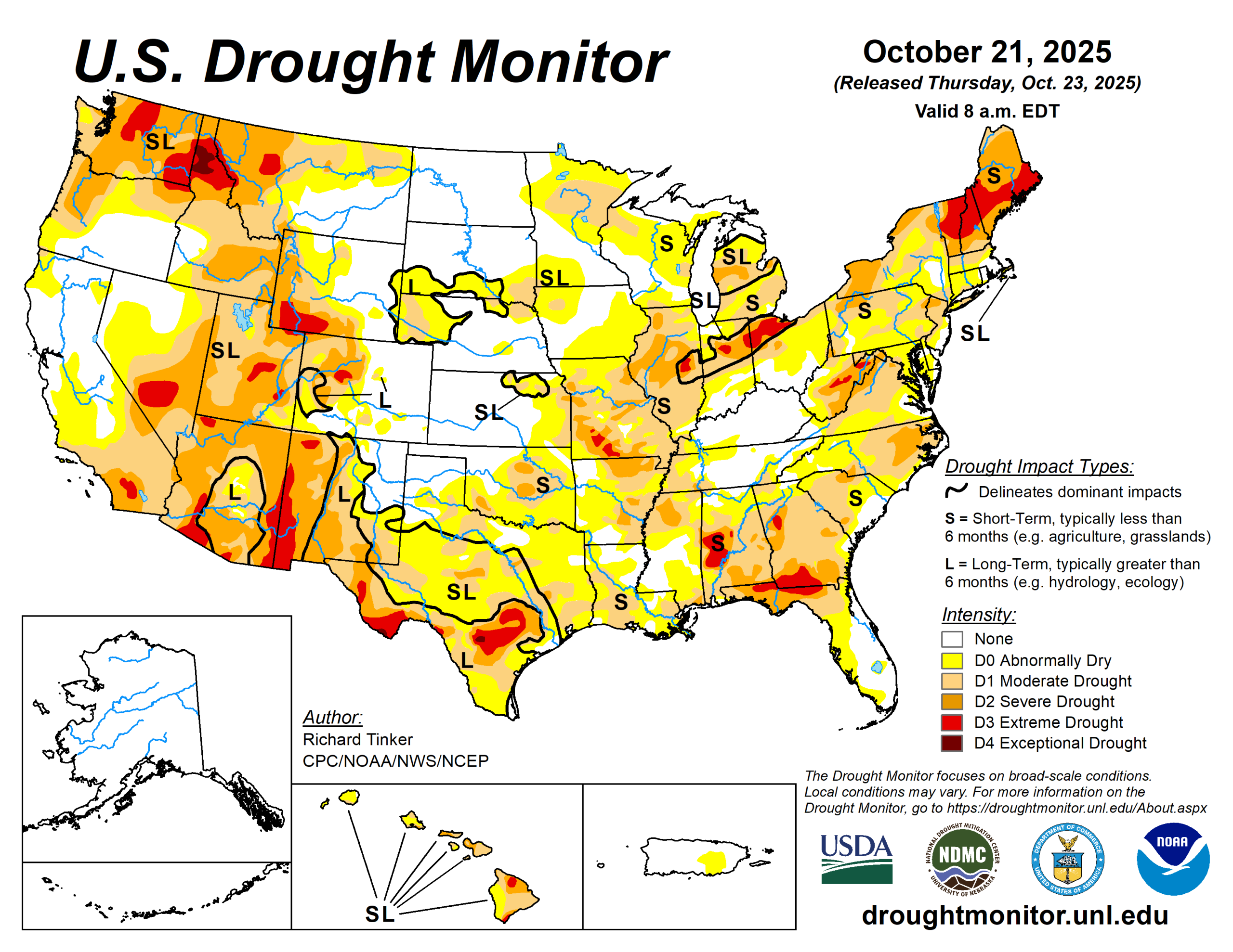
In summary, the array of improvements and deterioration incorporated into this week’s Drought Monitor resulted in slight declines in overall coverage of the various drought severity levels across the Lower 48. Abnormally dry or worse conditions cover 72% of the country, down from 74% last week. About 21% of the country is experiencing severe drought or worse (D2-D4), down slightly from 23%. For the 50 states, plus Puerto Rico, in total, coverage of abnormally dry or worse conditions fell from 62 to just under 60.5%.
The U.S. Drought Monitor is jointly produced by the National Drought Mitigation Center at the University of Nebraska-Lincoln, the U.S. Department of Agriculture and the National Oceanic Atmospheric Administration. (Map courtesy of NDMC.)
South
Moderate to heavy rain resulted in several areas of improvement in eastern Oklahoma.
Farther south and west, subnormal precipitation continued for another week, resulting in numerous areas of deterioration from central and southern Louisiana westward across Texas and central through western Oklahoma. The proportion of the region experiencing some degree of dryness or drought (D0+) increased slightly this week, from 79% to about 80.5%. There was a bigger jump in areas covered by some degree of drought (37%, up from a bit over 32%).
The most intense drought (D3 with some isolated patches of D4) cover parts of the panhandle of western Texas and a sizeable part of south-central Texas. The heaviest rains this week (2 to 4 inches) were observed in a broken pattern from northwestern Louisiana through northern Mississippi. In contrast, southern sections of the Lower Mississippi Valley and the vast majority of Texas and Oklahoma received a few tenths of an inch at best, with most sites reporting no measurable precipitation.
Midwest
Many parts of the Midwest Region received moderate to heavy precipitation. There was some expansion of dryness and moderate drought from northern Minnesota through Iowa, where less precipitation fell.
Overall, the extent of any degree of dryness or drought (D0-D4) dropped only slightly by 1% (to 71%), but there was a more substantial decrease in the coverage of the most intense categories. Severe drought or worse (D2-D4) covered over 14.5% of the region on Oct. 14, but less than 10% this week. The worst conditions in the region included parts of southwestern Missouri. Between 2 and 4 inches of precipitation fell on a band in east-central Missouri.
High Plains
A wide range of precipitation totals were observed last week. Generally, 1.5 to 3 inches hit the northern and western Dakotas, much of central and eastern Wyoming, and scattered locations in northwestern Wyoming.
An inch or a little more fell on many locations in a swath from central Nebraska into southeastern South Dakota, but other locations reported several tenths of an inch of precipitation at best, with most areas from southwestern Wyoming through western Nebraska and from eastern Nebraska through Kansas reporting little or none.
This pattern resulted in less change here than in most other regions. Areas of deterioration were introduced in parts of the east-central and southeastern High Plains region while improvement resulted from heavier precipitation farther west.
The most widespread areas of improvement covered southwestern Colorado and western Wyoming. Coverage of dryness and drought is considerably lower in this region than in others, with the total area entrenched in some degree of dryness or drought (D0-D4) dropping slightly to a bit over 36% this week. The extent of extreme drought (D3) was almost cut in half, from 3.3% down to 1.7%. There is no D4 in the region, but D3 remains across much of southwestern Wyoming and part of central Colorado.
The proportion of the Great Plains states in this region experiencing some degree of dryness or drought (D0-D4) is relatively low compared to much of the Lower-48; specifically, 3% of North Dakota, 32% of South Dakota, 35% of Nebraska, and 28% of Kansas.
West
Some unusually heavy early-season rain and snow has affected portions of the West, including areas of central and southern California where October so far has been wetter than most such months on record. Large portions saw improvement on this week’s Drought Monitor in parts of eastern, southern and western Montana.
Only a portion of north-central Montana saw any deterioration. The total area covered by any dryness (D0-D4) declined from 80 to a bit over 74%.
Looking ahead
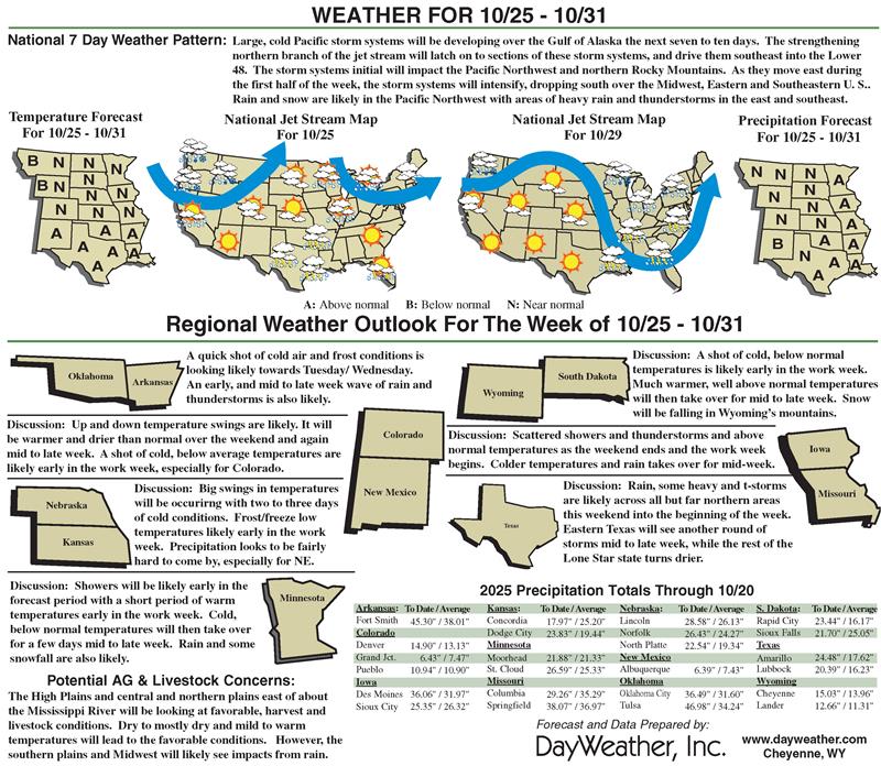
Over the next five to seven days, two general areas are expected to receive heavy precipitation. They are the Pacific Northwest, and a swath from the southern Great Plains through the Lower Mississippi and Lower Ohio Valleys.
Meanwhile, 3 to 5 inches are expected from the Red River (South) Valley into eastern Texas and parts of the Lower Mississippi Valley. Moderate amounts (0.5 to locally over 1.5 inches) are expected to fall in the southern half of the Plains outside Deep South Texas. Look for a few tenths to around an inch of precipitation in the northern Sierra Nevada, plus portions of the northern Intermountain West and Rockies.
Elsewhere, light amounts at best are anticipated in in the deep of south Texas. Meanwhile, unusually warm weather will likely continue across the northern Plains, with daily highs averaging 5 to 10 degrees Fahrenheit above normal from northern Minnesota through the Dakotas and northern Great Lakes into northeastern New York.
Also, highs averaging 4 to 8 degrees above normal are expected from the Southwest through western and southern Texas. Low temperatures should be warmer than normal across most of the Lower 48, especially over the Plains and the Southwest. Low temperatures could average 6 to 13 degrees above normal in the northeastern Great Plains and adjacent areas.
The Climate Prediction Center’s 6- to 10-day outlook valid through Nov. 1 favors heavier than normal precipitation continuing across the Pacific Northwest, where odds for significantly above-normal precipitation range from 50 to 70%.
Wet weather is slightly favored across most of the Rockies and Plains. Abnormally dry weather is expected from central and western Texas through central and southern sections of the High Plains and Rockies. Odds for subnormal amounts exceed 50% from eastern Arizona through parts of the Texas Big Bend. Meanwhile, warm weather is favored in the Southwest, and the Great Basin through parts of the northern Rockies, the High Plains, and the northern Great Plains. There is a better than 60% chance for warmth into western New Mexico.
Richard Tinker is with National Oceanic Atmospheric Administration, National Weather Service, National Centers for Environmental Prediction, and Climate Prediction Center.
Related Articles