A series of storm systems moved quickly across the lower 48 states until reaching the East Coast as a strong ridge of high pressure over the western Atlantic Ocean blocked their eastward progression, according to the U.S. Drought Monitor for April 23 released April 25. Due in part to this slowdown, severe weather and heavy rainfall occurred in portions of the southern Great Plains, lower Mississippi Valley, Southeast, and mid-Atlantic during April 17-19. Moderate to heavy precipitation (1.5-4 inches) also occurred over the western Great Lakes region, Tennessee and central Ohio Valleys, parts of New England, and northwestern Washington. Light to moderate precipitation (0.5-2 inches) was widespread in the Northwest, eastern Great Basin, northern and southern thirds of the Rockies, northern Plains, and the eastern third of the Nation. Only portions of the Southwest, central Rockies and Plains, and western Corn Belt saw little or no precipitation. Weekly temperatures averaged above normal for much of the contiguous U.S., except for subnormal readings across the Southeast and western and southern Alaska. Light to moderate precipitation along the southern and southeastern Alaskan Coast and light showers on the windward side of the Hawaiian Islands maintained conditions in both states. Changes were made in Puerto Rico as spotty heavy showers provided some relief to short-term D0 and D1 areas, but where the rains missed, some deterioration occurred.
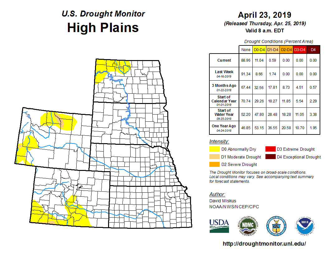
With near-record to record wetness in many parts of the country this winter and in 2018, the April 16 USDM had the lowest percent of area in drought (D1-D4) for the lower 48 states (3.73%) and all 50 states (3.78%) since the inception of the U.S. Drought Monitor in 2000, surpassing the previous low drought standard of May 23, 2017. In fact, no dryness/drought (D0-D4) in both the lower 48 (85.88%) and all 50 states (87.06%) also set record low values last week. With more wet weather over D0-D2 areas this week, new USDM record lows will most likely be set.
A fairly large area of light to moderate precipitation (0.5-1.5 inches) was observed across most of Montana, southern North Dakota, western and southeastern South Dakota, Wyoming, and western and northeastern Nebraska. Southern Kansas also received some decent rains (0.5-2.5 inches), as did southern Colorado (0.5-1.5 inches). The precipitation in Colorado was enough to improve D1 to D0 (see West summary with respect to New Mexico). In southwestern Wyoming, the additional precipitation boosted WYTD average basin precipitation and SWE to 112% and 123%, respectively, thus D1 and D0 was shrunk. In northern Wyoming, 0.5-1.5 inches of precipitation was enough to create WYTD and YTD surpluses near the northern and southern D0 edges, thus erasing some of the D0. However, the D1 in the Bighorn Mountains remained intact as both WYTD basin average precipitation and SWE still stayed around 75% of normal. In contrast, extreme northern Montana and North Dakota have missed out on the precipitation, and at 60-days, only 25-50% of normal precipitation has fallen, leading to deficits of 0.5-1.5 inches. In addition, a rapid snow melt during mid-March left much of the water to run off instead of percolating into the still frozen subsoil, thus D0(S) was added. Longer time periods were wet, but since this is the start of the wet season, it is critical that timely and adequate rains fall during the next few months for agricultural interests. Short-term (2-3 months) deficits in central Kansas were also accumulating, but large longer-term surpluses have kept D0 from developing so far.
The Midwest remained D0 and drought-free as a wet 2018 and wet 2019 continued to dominate the soils. This week, moderate to heavy rains (1.5-4 inches) fell across southern Minnesota, northern Wisconsin, and the Upper Peninsula of Michigan, while another band of decent rain (1.5-3 inches) was measured from southeastern Michigan southwestward into central and western Kentucky. In contrast, little or no rain was observed across most of Iowa, northern Illinois, northern Missouri, and eastern Ohio. According to USDA’s NASS on April 21, every Midwestern state reported little or no topsoil or subsoil moisture shortages (0-2% short or very short), with several states reporting 25-60% surpluses. Some hint of dryness at 1-2 months was showing up in southern Iowa and northern Missouri and it will be watched, but for now it was welcome news for farmers to get into the fields for preparation and planting.
Two different storm systems brought welcome precipitation to the South. Early in the period, central and eastern Texas and the lower Mississippi and Tennessee Valleys received widespread moderate to heavy rains (1.5-3 inches, locally to 6 inches) that erased much of the short-term D1 and D0 in central Texas, eastern Louisiana, and southwestern Mississippi. The few areas that received less than an inch of rain, or where 60- to 90-day significant deficits still remained, were left unchanged. In contrast, parts of west-central Texas (Edwards Plateau) missed out on the rain, and some slight D1 and D0 expansion was made here, and additionally in northern Webb County. The second system which occurred late in the period dropped beneficial precipitation on the southern Rockies (New Mexico mountain snows) and south-central Plains (Texas Panhandle and west-central Oklahoma), easing dryness and drought there (see West for New Mexico). Some short-term (2-3 months) dryness was found in northern and central Oklahoma, but longer-term wetness has kept D0 development at bay so far. Elsewhere in the South, overall wet conditions prevailed.
Related Articles