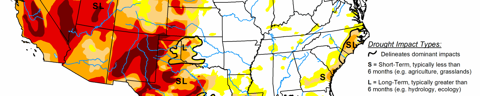
Several upper-level troughs and closed lows moved in the westerly jet stream flow across the contiguous U.S. during this U.S. Drought Monitor week. They dragged surface fronts and low pressure systems along with them.
The weather systems moved across the West then generally followed two storm tracks after crossing the Rockies—one track was along the Canadian border, while the other track was along the Gulf Coast states. As a result, above-normal precipitation fell across parts of the West, much of the Gulf Coast from eastern Texas and Oklahoma to Georgia, parts of the Mid-Mississippi Valley, and parts of the northern Great Lakes and Maine. Precipitation amounts were generally 0.5-2.0 inches in the West where precipitation fell, but exceeded 2 inches across a large part of the Gulf Coast states. The rest of the CONUS had below-normal precipitation for the week. A swath from New Mexico to Lower Michigan, and parts of the northern Plains and Far West, had little to no precipitation. With upper-level troughs and surface cold fronts dominating the circulation pattern, weekly temperatures averaged below normal across most of the CONUS.
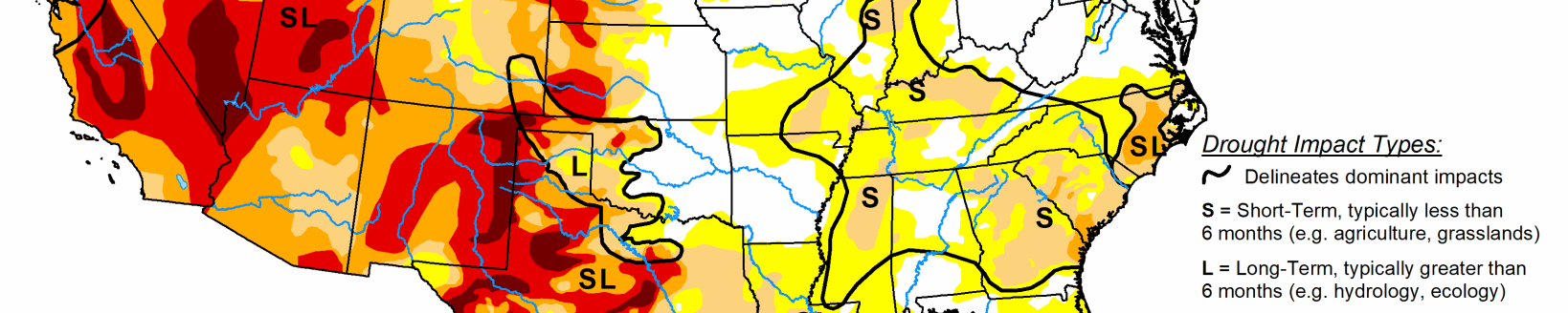
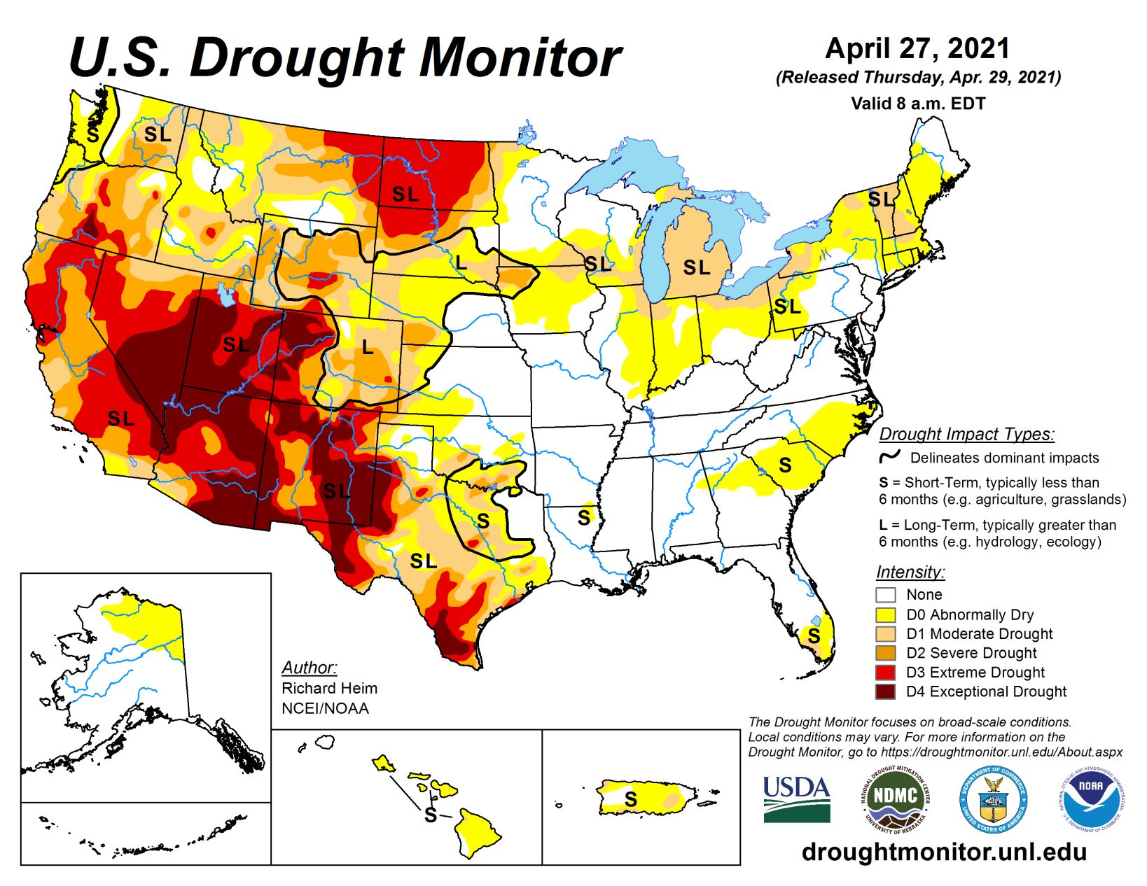
Drought or abnormal dryness contracted in parts of the southern Plains to Southeast, where heavy rains fell, and in parts of the northern Plains and Northeast, where overall conditions warranted improvement. But drought or abnormal dryness expanded or intensified across parts of the West, Midwest, other parts of the Plains, and the Carolinas, as well as much of Hawaii and Puerto Rico. In these areas, precipitation deficits grew and soils continued to dry. These changing conditions were reflected in several drought indices and indicators, including the Standardized Precipitation Index, streamflow and groundwater levels, soil moisture measurements on the ground and from satellite as well as soil moisture models, vegetation-based indices such as VegDRI, and mountain snow water content in the West.
South
In the southern Plains, the western half of Texas and Oklahoma were dry this week, with little to no rain falling. But a half inch or more of rain was widespread across the rest of the South, with 2+ inches in streaks across eastern Oklahoma and Texas, Arkansas and Louisiana, and southern Mississippi. D0-D3 contracted in eastern Texas, D0-D2 contracted in parts of Oklahoma, D1 disappeared and D0 contracted in Louisiana. But further west, D0-D4 expanded in southern and southwest Texas and D0 expanded in western Oklahoma. Dry or very dry soils grew in area to 67% of Texas and 29% of Oklahoma, according to USDA statistics, and 43% of the winter wheat crop in Texas was in poor to very poor condition. In the Midland-Odessa, Texas, area, 2020-2021 had the driest 13-month April-April period on record, and the fourth driest any 13-month period ever (behind 2011 which had the top 3 driest 13-month periods). Falling levels of the Edwards Aquifer triggered water restrictions in several Texas communities, including San Antonio, New Braunfels, and San Marcos.
Midwest
In the Midwest, a half inch of precipitation fell along the Ohio and Mid-Mississippi Rivers, parts of northern Ohio and Indiana, and central Minnesota to Upper Michigan. Parts of far northern Wisconsin had an inch or more. But much of the Ohio Valley states, and Iowa to Lower Michigan, had little to no precipitation this week. Streamflow, soil moisture, and 1- to 2-month SPI indicators prompted expansion of D0 in Illinois, Indiana, and Ohio, while D1 expanded in northern parts of Indiana and Illinois, across southern Wisconsin, into southeast Minnesota and northeast Iowa where deficits were mounting as seen in 1- to 4-month SPI values. D0 also expanded in the latter 3 states. D1 was expanded across Lower Michigan where precipitation deficits over the last 90 days have been building, streams are low, and soil moisture continues to dry. USDA statistics show 30% of the state is experiencing topsoil moisture that is short to very short (dry to very dry), an increase of 17% over the last week. The statistics increased to 34% in Iowa, 25% in Minnesota, and 21% in Wisconsin.
High Plains
There were patches of 0.5-1.0 inch of precipitation in southeast Kansas, the Dakotas, Wyoming, Colorado, and the western half of Montana this week. But most of the region was dry, with less than 0.25 inch of precipitation falling. With improving conditions in the short-term (last 1-6 months), D0-D2 were pulled back in parts of South Dakota and northeastern Wyoming. But D4 expanded in northwest Colorado, and D3 expanded in eastern North Dakota where this week was dry and 6-9-month SPI are D3-D4, deeper soils are bone dry, streams are low, and stock ponds are dry or almost empty. D1-D3 expanded in northern Montana, D0-D2 expanded in western Wyoming, and D0 expanded in southwest Kansas.
In the Montana Highline, reports were received from Blaine and Hill Counties of low soil moisture and stockwater ponds failing to fill. Three dozen reports were received from North Dakota, through the Condition Monitoring Observer system, of drying ponds and creeks, hay and feed shortages, and fire risk. USDA statistics rate more than half of the topsoil short or very short of moisture in Colorado (57%), Montana (57%), and Wyoming (55%), and nearly two-thirds or more so rated in South Dakota (62%) and North Dakota (80%); 32% of the winter wheat crop in Colorado was rated in poor to very poor condition. Several Colorado communities were asked to voluntarily conserve water.
West
Precipitation amounts from the Pacific weather systems that moved across the West this week were patchy and not enough to erase months of deficits. Half an inch to locally 2 inches fell across coastal areas and coastal ranges of Oregon, Washington, and northern California; in the Sierra Nevada; northern and central Rockies; and Great Basin ranges. Rainshadow areas and valleys, and much of the Southwest, received little to no precipitation. There were minor contractions of D4 in New Mexico and D0 in Idaho, but worsening dry conditions prompted expansion of drought and abnormal dryness in several western states. D1-D3 expanded along the northern California coast, D0-D2 expanded in the Pacific Northwest, and D3 expanded in western New Mexico.
Related Articles