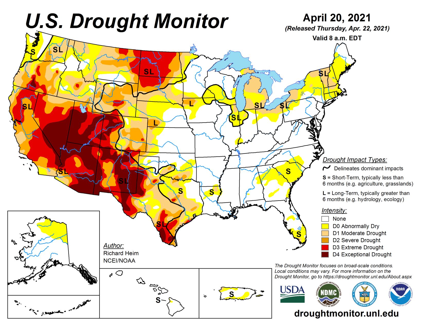
The upper-level circulation over the contiguous U.S. during this U.S. Drought Monitor week consisted of a ridge over the West Coast and trough over the north central states. Strong closed lows rotated within this upper-level flow, bounding from the Southwest to the Northeast in their trek across the country.
The ridge blocked Pacific moisture from entering the country and kept the West Coast warmer than normal for the week. The trough funneled cold and dry Canadian air into the Plains. The cold fronts moved south and east, bringing colder-than-normal air to much of the CONUS from the Great Basin to the Appalachians and beyond to the Mid-Atlantic Coast. Only parts of the Southeast and Northeast averaged warmer than normal for the week. The fronts and their surface lows brought rain and snow to the northern and central Rockies as they bumped up against the mountains, with precipitation amounts meeting or exceeding weekly normals in parts of the northern to central Rockies and High Plains.
The fronts and surface lows spread above-normal rainfall across Oklahoma and northern Texas to Florida, with amounts along the northern Gulf Coast exceeding 5 inches in places. They also brought rain to the Northeast, with some areas nearing or exceeding weekly normals. But much of the West, northern Plains to Ohio Valley, Southeast, and Maine were drier than normal for the week. Streamflow was well below normal all along the West Coast and in the interior West, in North Dakota and northwest South Dakota, parts of southern Texas, the southern and eastern Great Lakes, and parts of the Northeast. Soils continued to dry out in the West and Southeast, according to U.S. Department of Agriculture reports.
Satellite and station reports, as well as modeled indices, showed dry soils across the West, northern and southern Plains, the southern and eastern Great Lakes, and into the Northeast, as well as parts of the Southeast. Groundwater observations from wells and estimated from satellite measurements revealed dry conditions across the West, northern and southern Plains, Northeast, and parts of the Southeast. The cumulative effect of lack of precipitation and drying soils has stressed vegetation, as seen in such indices as the Vegetative Health Index and VegDRI, as well as field reports.
South
Heavy rains fell across frontal zones over Louisiana and southern Mississippi where up to 5 inches was reported for the week. Rainfall totals of 2 inches or more covered most of Louisiana into northeast Texas and parts of Oklahoma. Half an inch or more was widespread across Arkansas, eastern to central Oklahoma, and northern, eastern, and extreme southern Texas. Meanwhile, most of the Rio Grande Valley, west Texas, and western Oklahoma received little to no precipitation. Drought and abnormal dryness contracted in parts of Louisiana, Oklahoma, and Texas, while extreme (D3) to exceptional (D4) drought expanded in parts of west Texas. The rains improved soils across parts of Texas and Oklahoma, but USDA reports still have 60% of Texas and 26% of Oklahoma with topsoil moisture short or very short.
Midwest
Precipitation brushed the edges of the Midwest region, with half an inch or more falling over parts of western Missouri, southwest Iowa, northern Minnesota, and Upper Michigan. Most of the region received less than 0.25 inch of precipitation for the week. D1 expanded in northeast Illinois, northern Ohio, and across much of Michigan. D0 expanded in parts of Illinois, Indiana, Michigan, and Ohio. But D0 and D1 contracted in northern Minnesota where recent precipitation has reduced drought indicators. USDA reports of short or very short topsoil moisture ranged from 9% in Illinois to 29% in Iowa. County extension field reports in east central Indiana included drought impacts on planting, pasture growth, and pond levels.
High Plains
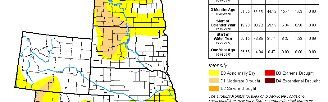
Cooler temperatures and snow spread across parts of the northern Plains this week. Western and southern parts of the High Plains region received 0.5-1.5 inches of precipitation this week, while the Dakotas were mostly dry with less than 0.25 inch. Precipitation in Wyoming in recent weeks has improved several drought indicators, especially the Standardized Precipitation Index (SPI), resulting in significant contraction of the D3 area in the central part of the state. D0-D2 shrank in other parts, but D1-D2 expanded in western Wyoming. Colorado saw contraction of D1-D2 in the north. Half an inch to over an inch of precipitation in southwest South Dakota shrank D2, while D2 was removed from southeast South Dakota due to improving indicators. Even though much of Montana received welcome snow this week, in most areas it amounted to below-normal precipitation, so D1-D3 expanded.
Abnormal dryness contracted in south central Montana where precipitation has been above normal. In North Dakota, the snow was enough to prevent further deterioration but not enough to reduce deficits. Parts of the state remain in a burn ban and are experiencing dry soils, poor pasture conditions, and drying ponds and dugouts, some of which were testing high in TDS and sulfates. Producers are selling or making plans to cull more livestock. Dust storms have been reported recently in North Dakota and Montana. USDA reports show 78% of North Dakota, 61% of Montana, 58% of South Dakota, 56% of Wyoming, and 49% of Colorado with topsoil moisture short or very short.
West
Just the higher mountains of northern Utah, northeast Nevada, and the Sierra Nevada in California received any precipitation this week, and that was only 0.25-1.5 inches, which was barely normal for this time of year. Most of the rest of the West received no precipitation. Low streamflow, dry soils, and precipitation deficits over the last 3 months or longer prompted expansion of abnormal dryness and drought all along the West Coast. In Washington, D0 expanded to the coast and D1 spread northeastward, with only above-normal snow water content (SWE) and water-year-to-date (WYTD) precipitation keeping the Olympic and Cascade Mountains free of abnormal dryness. The D1, and some D0, spread across northern Idaho and into northwest Montana. D1-D2 expanded in western and northeastern Oregon. D1-D3 expanded in California to better reflect the soil moisture, streamflow, and SPI indicators. Agricultural impacts along the southern California coast were especially severe. The sparse timing of rain that has occurred this season (end of December and end of January) has contributed to especially poor growth of the annual grasses that are needed for livestock feed. According to reports, the amount of forage on rangelands is low, with producers in Ventura County already shipping whole herds of cattle out of county because there is almost no forage. As the USDM week ended, California Governor Newsom declared a drought emergency in Mendocino and Sonoma counties. Other drought impacts around the region: Historically low water levels caused the closure of some launch ramps on Lake Powell. The Klamath Project will receive 33,000 acre-feet of water in 2021, about one-tenth the average amount, for the lowest allocation in the project’s history, due to drought and low inflows into Upper Klamath Lake. Dust storms have been reported recently in Oregon and blowing dust in eastern Washington. According to USDA reports, the percentage of topsoil moisture short or very short jumped this week to 65% of California and Oregon and 60% of Washington. The percentage increased slightly to 87% of New Mexico. April 21 reports of mountain SWE in California included 32% of normal in the North, 37% in the Central, and 16% in the South.
Related Articles