Severe drought continues in southwest Kansas
An area of upper-level low pressure entered southern California by Dec. 26 and then progressed east across the Four Corners region. This upper-level low resulted in heavy rain and high-elevation snow from southern California east to southwest Colorado and New Mexico. A surface low developed across the south-central Great Plains on Dec. 28 with a subsequent track northeast to the upper Mississippi Valley and Great Lakes. Heavy snow fell to the northwest of this low pressure system, while moderate to heavy rainfall accompanied the cold front as it shifted east from the Great Plains to the East Coast.
Following the heavy precipitation across the Pacific Northwest during mid to late December, precipitation average below normal during the final week of December. Enhanced onshore flow resulted in periods of heavy precipitation along the Alaska Panhandle, but longer-term precipitation deficits persist. A low pressure system and trailing front brought locally heavy rain and damaging winds to parts of the Hawaiian Islands this past week.
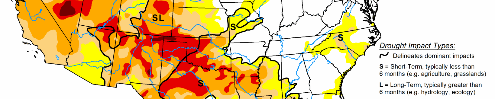
South
As an upper-level trough ejected from the desert Southwest, a surface low developed over the southern Great Plains. Beneficial rainfall (more than 1 inch) resulted in improving conditions across the eastern Oklahoma Panhandle and northwest Oklahoma. Moderate (D1) to severe (D2) drought continues across southwest Oklahoma and adjacent areas of the Texas Panhandle and northwest Texas which received lighter rainfall amounts (0.75 inches of less). Changes to the drought depiction across the remainder of Texas included a slight reduction in D0/D1 in central and southwest parts of the state, based on recent rainfall and lack of short-term dryness. Although it was a dry week across deep southern Texas, a reassessment of indicators supported a slight reduction of severe (D2) drought. A small area of severe (D2) drought was added to Burleson County, based on 120-day indicators. On December 29, a cold front crossed the lower Mississippi Valley where 0.5 to 2 inches of rainfall occurred. The heaviest rain fell to the north and east of the ongoing D0 to D2 areas.
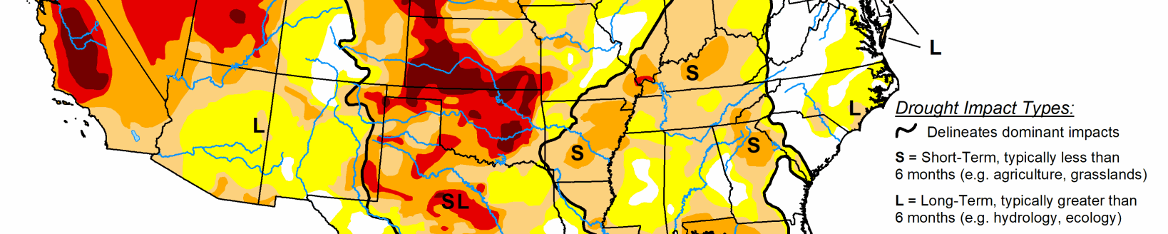
Midwest
A low pressure system and trailing cold front brought widespread rain and snow to this region on Dec. 29 and 30. Abnormal dryness (D0) was added the previous week to parts of central Indiana based on 90-day precipitation deficits of 2 to 4 inches and 28-day stream flows below the 30th percentile. This D0 area was decreased slightly where more than 0.5 inch fell. Elsewhere, 90-day precipitation averages 150 to 200, or more, percent of normal across Kentucky, Michigan, Wisconsin, Minnesota, and the northwest two-thirds of Iowa.
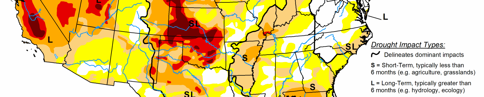
High Plains
A low pressure system developed across the southern Great Plains on Dec 28 and then tracked northeast to Iowa and Minnesota. Along and northwest of the surface low track, beneficial precipitation (0.5 to 1.5 inches) fell from the western half of Kansas north to southern and eastern Nebraska. This recent precipitation prompted a 1 to 2-category improvements to the short-term drought areas in Kansas. A 2-category improvement was justified where more than 1 inch of precipitation occurred and 90-day precipitation is either at or above normal. However, severe drought (D2) continues west of Garden City and Liberal, Kansas. In contrast to the improving conditions for Kansas, abnormal dryness (D0) was extended north across western Wyoming where 90-day precipitation deficits are 2 to 6 inches. Drought impacts were modified to long-term only in southwest Colorado due to recent snowfall. Snow water content is running 125 to 135 percent of normal as of December 29, but 6-month SPI values support the severe drought (D2) category in southwest Colorado.
West
A vigorous upper-level trough crossed southern California and the desert Southwest from December 25 to 27. Widespread moderate to heavy rain and high-elevation snow (0.5 to 2 inches, liquid equivalent) accompanied this upper-level trough. Snowfall amounts exceeded two feet in the mountains of southern California, while 4 to 12 inches was recorded in the higher elevations of Arizona. This recent precipitation along with support from longer-term SPI values resulted in a 1-category improvement to Dx levels in parts of Arizona and southwest Utah. 180-day precipitation deficits remain the largest (more than 6 inches) across southwest Colorado.