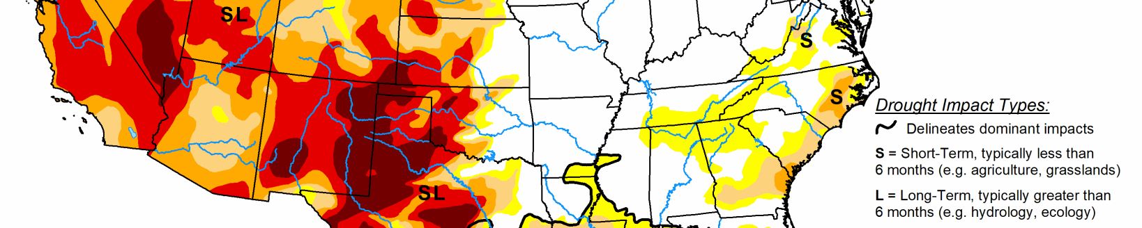
Scattered showers bring some relief to southwest Kansas and southeast Colorado
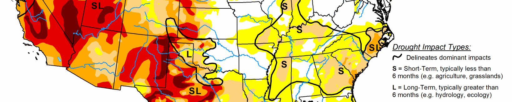
A trough of low pressure over the West kept much of the Northwest and Southwest unseasonably cool for early July, while high pressure, high humidity, and stalled or slow-moving fronts were the focus for scattered showers and thunderstorms across most of the Plains, middle and lower Mississippi and Tennessee River Valleys, the Southeast, and along eastern sections of the mid-Atlantic and New England.
Little or no precipitation fell on most of the Far West, Southwest, southern Texas, the Corn Belt, and western portions of the mid-Atlantic and New England. Temperatures averaged above normal east of the Rockies, especially in the Northern Great Plains, upper Midwest, and Great Lakes region that saw weekly departures of +4 to 10 degrees F.
South
Scattered showers and thunderstorms also dotted the South just like the Southeast, although some areas completely missed out on the rains. This included central and southern Texas, central Oklahoma, northern Louisiana, central and northeastern Arkansas, and western Tennessee. The rains were welcome in northern Texas and western Oklahoma Panhandles, but the spotty nature of the thunderstorms made for an interesting drought depiction. Overall, some 1-category improvements were made to both areas, but large swatches of D2-D3 remained. Removal of the D0 areas in western Tennessee, Mississippi, and northeastern Texas were made if enough precipitation fell (generally more than 1.5 inches), but kept if weekly amounts were less, or 2-3 month deficits were still too large. Where little or no precipitation fell, degradation occurred when 30-, 60-, or 90-day deficits were large enough. This included parts of south-central Texas and central and northeastern Oklahoma. Tulsa, OK, measured only 0.11” of rain in June, its driest June since local records began in 1893. Southern Texas was left status-quo as 2-3 month surpluses were large enough to stave off this week’s dryness and heat, but rain will be needed soon. According to the USDA/NASS, crop conditions are a mixed bag depending on which state and which part of that state the crop is grown. Soybean and/or corn conditions were rated fair to good in Texas, Tennessee, Louisiana, Arkansas, and Mississippi, cotton and winter wheat rated 36% and 28% poor or very poor in Texas, respectively. In contrast, Oklahoma only had 7% winter wheat in poor or very poor condition, but much of Texas and Oklahoma’s winter wheat crop was already harvested. Topsoil moisture as of July 5 was 64% short or very short in both Oklahoma and Texas, with much lower values in Southern states to the east.
Midwest
Much of the Midwest saw little or no rain this week, with significant totals limited to far western and southern sections, and a swath of moderate rain (1.5 to 3.5 inches, locally to 6 inches) from western Illinois southward into western Kentucky and Tennessee. Temperatures averaged above-normal also, with weekly departures of +4 to 10 degrees F in the upper Midwest and Great Lakes region.
D1 expanded or developed in central Illinois, western Iowa, northeastern and central Minnesota, and southwestern Missouri. D2 was introduced into northeastern Minnesota as many of the indices were at very dry levels (SPIs at 2-6 months equal to D3-D4 levels), 4-8 inch deficits at 90-days, and USGS stream flows in the lower tenth percentile.
Most Midwest states received surplus long-term moisture, but short-term dryness is affecting some areas. The Midwest states with the highest July 5 topsoil moisture rated short to very short included Indiana (45%), Ohio (70%), and Michigan (71%), but most other states saw a weekly increase in dryness.
High Plains
A second week with widespread and abundant rains across much of the Dakotas and Montana, along with field reports on the rains impacts, justified large-scale 1-category improvements in western North Dakota (D1 to D0), northwest South Dakota (D1 to D0), southeastern Montana (D1 to D0), southwestern South Dakota (D0 to none), and parts of Montana (D0 to none).
Field crops have responded, with both Dakotas reporting mainly fair to good conditions for corn, soybeans, barley, oats, winter and spring wheat, along with pasture and range conditions. Montana’s wheat and barley were also doing well. Farther south, scattered showers brought some relief to hard-hit sections of southwestern Kansas (D3 and D2) and southeastern Colorado, the latter area where the D4 area was eliminated after 0.5-2.5” of rain. In eastern Colorado, Kit Carson County received heavy rain, necessitating a D0 bubble on the map. However, where the rains were not as plentiful or were missed, dryness and drought expanded. This included D0 and D1 expansion in south-central North Dakota, northeastern and southeastern South Dakota, northeastern, south-central, and southwestern Nebraska, and southeastern Kansas. In Wyoming, a reassessment of conditions from field reports and indices included some reduction of D0 and D1 in western sections where it has been wet the past 30-days, but the addition of 3 small D2 areas in central and southeastern sections. The former lone D2 area in Wyoming was removed as indices did not support it.
West
Seasonably dry but unseasonably cool weather prevailed over much of the West, with mostly light precipitation (less than 1 inch) limited to the northern Cascades, northern Rockies, and eastern New Mexico. With precipitation normal generally low during July (except for the southwest monsoon which should be ramping up soon) and temperatures below-normal, most areas were status-quo except for the following exceptions.
The slow and warm start to the southwest monsoon season in southeastern Arizona and southwestern New Mexico was depicted with an expansion of D0 there. In eastern New Mexico, although spotty light to moderate (0.5-2 inches) showers fell, most areas remained status-quo as longer-term conditions will need much more moisture for significant improvement. Only small areas in eastern New Mexico where the totals exceeded 2 inches were improved by 1-category. However, in central areas where the rains missed, D1 and D2 were expanded westward to reflect the continuing deterioration of ground and vegetation conditions.