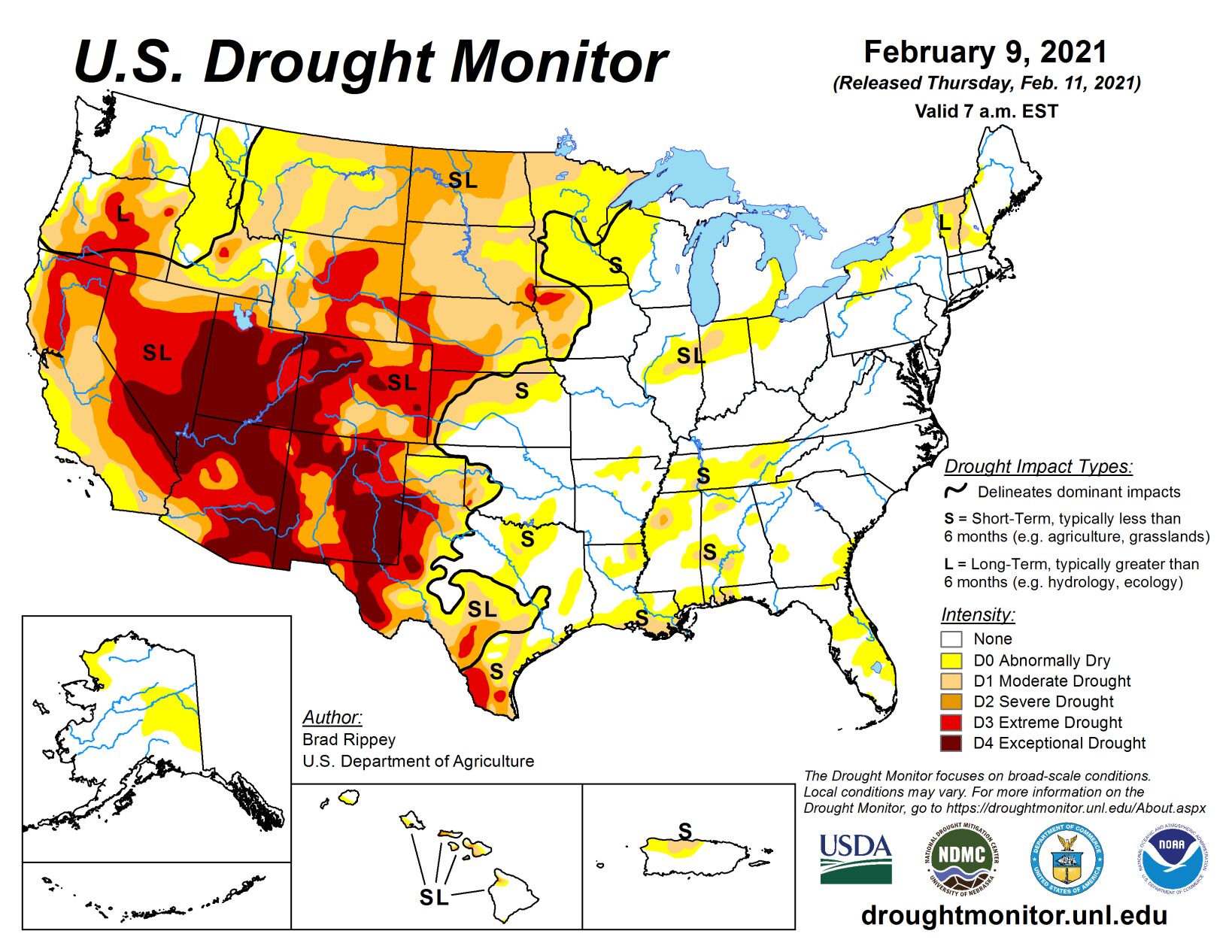
A slow-moving coastal storm delivered heavy precipitation in parts of the Northeast on Jan. 31 to Feb. 1, with impacts (windy weather and snow showers) lingering for several days. Later, the focus for stormy weather briefly returned to the western U.S., although significant precipitation was confined to the northern Rockies and Pacific Northwest.
By Feb. 4, wintry weather shifted into the upper Midwest, where blowing snow and gusty winds briefly resulted in blizzard conditions. The same weather system produced generally light rain across the South. Later, additional patchy precipitation fell in the central and eastern U.S., although dry weather prevailed during the drought-monitoring period across much of the nation’s southwestern quadrant. At the height of the early-February cold outbreak, temperatures plunged below -20°F across portions of the northern Plains and upper Midwest. Sub-zero readings occurred across a much larger area, extending southward across the central Plains and into the middle Mississippi Valley.
High Plains
Overall, there were few changes to the High Plains’ drought depiction. Frigid weather settled across the region in early February, accompanied by periods of snow mainly in Nebraska and upslope (western) regions. Mostly dry weather persisted, however, in several areas, including northeastern Montana and the Dakotas, where lack of snow cover remained a concern with respect to lack of insulation for winter wheat during the protracted spell of sub-zero temperatures.
In Glasgow, Montana, snow cover totaled an inch or less each day during the cold blast, which began with a low of 0°F on Feb. 4 and included at least four consecutive readings below -20°F from Feb. 7 to 10. In contrast, parts of Nebraska remained beneath a blanket of snow, some of which had fallen during a major storm on January 25. However, some additional snow fell in Nebraska and environs during the drought-monitoring period. For example, the weekend of Feb. 6 to 7 featured Nebraska snowfall totals of 11.6 inches in North Platte, 9.6 inches in Lincoln, and 9.3 inches in Grand Island.
South
Despite a few showers, the general trend toward drier conditions continued, with some increasing coverage of abnormal dryness (D0) and moderate drought (D1) in Arkansas, Louisiana, Mississippi, and Tennessee. During the first 40 days of the year (Jan. 1 to Feb. 9), precipitation ranged from one-third to one-half of normal in locations such as Crossville, Tennessee (3.02 inches, or 49% of normal); Meridian, Mississippi (3.24 inches, or 46%); Lake Charles, Louisiana (2.86 inches, or 45%); Greenville, Mississippi (2.95 inches, or 43%); Jackson, Tennessee (2.25 inches, or 41%); New Iberia, Louisiana (2.57 inches, or 40%); Lafayette, Louisiana (2.78 inches, or 39%); Monroe, Louisiana (2.43 inches, or 38%); Vicksburg, Mississippi (2.37 inches, or 36%); and New Orleans, Louisiana (2.39 inches, or 35%). Short-term dryness also extended westward to coastal Texas, where some D1 was introduced between Port O’Connor and Galveston. During the first 40 days of the year, rainfall in Galveston totaled just 0.81 inch (16% of normal).
Meanwhile, persistent warmth accompanied dry weather in southern Texas, resulting in growing coverage of moderate to extreme drought (D1 to D3). Drought deterioration was also noted on the High Plains, particularly in northern Texas and portions of neighboring states. According to the U.S. Department of Agriculture, statewide topsoil moisture in Texas was rated 55% very short to short on February 7, although agricultural district values were as high as 96% on the Northern High Plains (Amarillo area), 90% in the Lower Valley (Brownsville area), and 84% on the Southern High Plains (Lubbock area). In addition, 53% of Texas’ rangeland and pastures were rated in very poor to poor condition on that date, along with 31% of the winter wheat.
Midwest
The region’s biggest storm of the drought-monitoring period struck on Feb. 4 to 5, featuring wind-driven snow across the upper Midwest. Feb. 4 snowfall totals greater than 5 inches were accompanied by peak wind gusts to 40 mph or higher in locations such as La Crosse, Wisconsin (5.8 inches and 40 mph), and Dubuque, Iowa (5.2 inches and 44 mph). In Wisconsin, daily-record snowfall amounts for February 4 reached 10.4 inches in Rhinelander and 8.0 inches in Antigo. A small amount of abnormal dryness (D0) was trimmed form the upper Great Lakes region. Elsewhere, the area of dryness (D0) and moderate drought (D1) stretching from the middle Mississippi Valley into the lower Great Lakes region was reduced in size on the western side but exhibited a small increase in coverage in eastern Indiana and western Ohio. As the drought-monitoring period progressed, bitterly cold air invaded the Midwest. Daily-record lows included -34°F (on February 8) in Hibbing, Minnesota, and -33°F (on February 9) in Merrill, Wisconsin.
West
Aside from widespread precipitation in the Pacific Northwest and northern Rockies, the western U.S. experienced a much more tranquil drought-monitoring period. In fact, little or no precipitation fell across southern California, the Great Basin, and the Southwest, although mostly status-quo drought coverage was noted in the wake of late-January storminess. Farther north, coverage of severe to extreme drought (D2 to D3) was reduced in parts of southeastern Montana and northeastern Wyoming. Meanwhile, Oregon’s changes were mixed, with some general deterioration of conditions in the northeast and further improvement west of the Cascades. Following the late-January storminess, the California Department of Water Resources indicated that the average water equivalency of the high-elevation Sierra Nevada snowpack stood at nearly 13 inches (65% of normal for February 10), well above the Jan. 24 value of 6 inches.