Widespread improvements made in drought conditions in Texas, Oklahoma
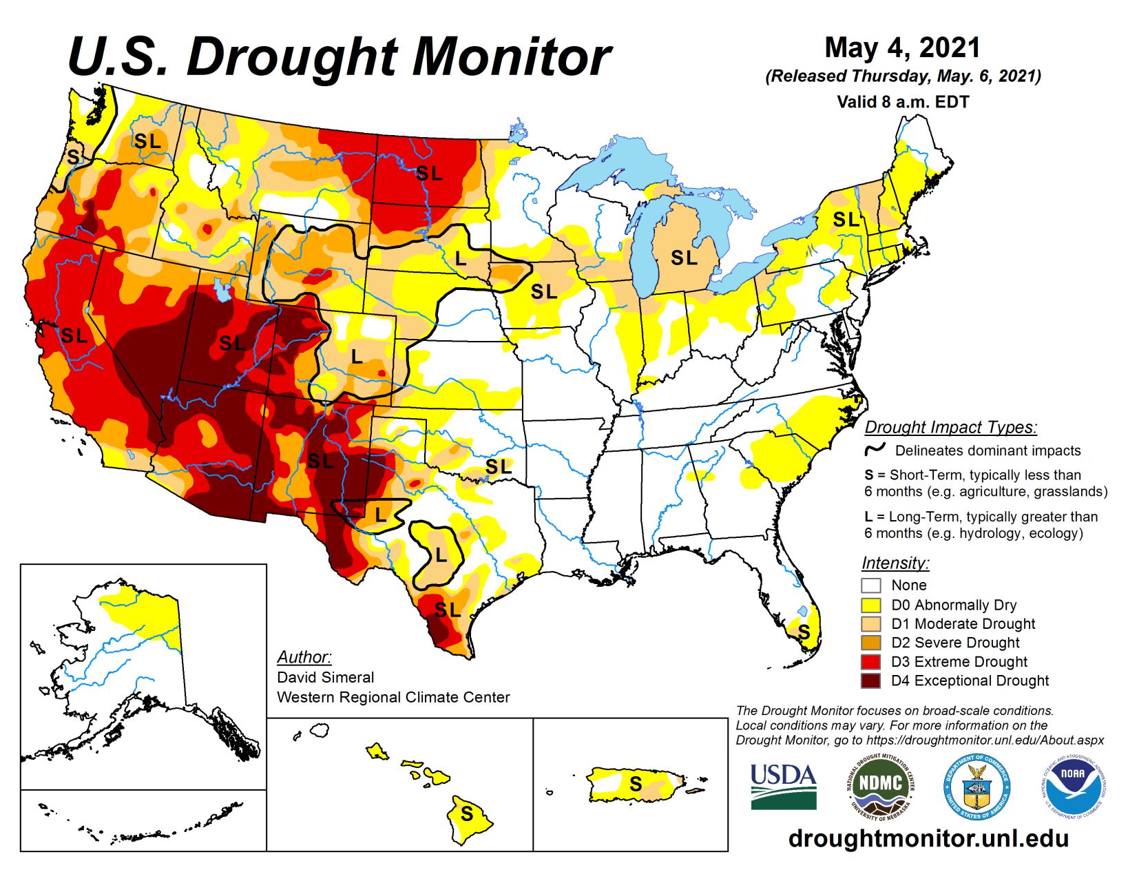
This U.S. Drought Monitor week saw an active weather pattern with severe weather observed across portions of the central and southern Plains, Texas, mid-South, Midwest, and the Northeast. In Texas, 7-day rainfall accumulations ranged from 2 to 10+ inches, leading to significant improvement in drought-related conditions across the state.
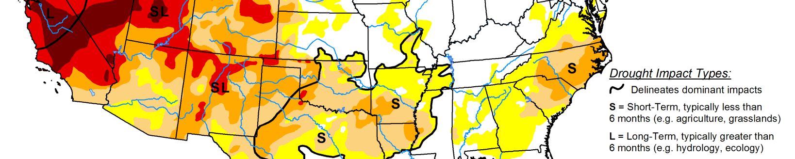
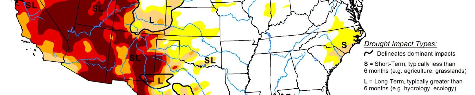
Likewise, areas of northeastern Colorado and portions of the central Plains received much-needed rainfall (2-to-4-inch accumulations) leading to improvements on the map. Out West, 83% of the region is currently in moderate-to-exceptional drought with the most severe conditions centered on the Four Corners states, California, and Nevada. In California, conditions deteriorated on this week’s map in response to a combination of factors including back-to-back dry water years, above-normal temperatures, below-normal snowpack, and drought impacts (agricultural, ecosystem health, water supply, recreation).
High Plains
On this week’s map, areas of the region—including Kansas, Nebraska, Colorado, and Wyoming—saw improvements, including a reduction in areas of Severe Drought (D2) in southwestern Nebraska and northwestern Kansas as well as in areas of Moderate Drought (D1) in northeastern Colorado and southeastern Wyoming. In northeastern Colorado, 2 to 4+ inches of rainfall were observed during the past week, which provided a timely boost in soil moisture conditions for recently planted crops. Elsewhere, areas of Extreme Drought (D3) expanded in northern South Dakota and southern North Dakota. In northwestern South Dakota, the town of Lemmon saw its driest January through April period on record with only 0.71 inches of precipitation observed. The South Dakota State Extension and the North Dakota State Climate Office are both reporting drought-related impacts in their respective states, including poor water quality for livestock and dry stock ponds. In western North Dakota, dry conditions and strong winds have been exacerbating fire-related conditions as firefighters are battling two wildfires in the Dakota Prairie Grasslands. Average temperatures for the week were above normal across the region with positive temperature anomalies ranging from 2 to 9 deg F above normal.
South
On this week’s map, widespread improvements in areas of drought were made across Texas (and southern and eastern Oklahoma) in response to significant precipitation accumulations (ranging from 2 to 10+ inches) with areas along the Texas Gulf Coast and the Hill Country receiving the heaviest accumulations. The slow-moving front that entered the region last week brought severe storms with frequent lighting, tornadoes, and softball-sized hail that caused extensive property damage with damage estimates expected to exceed $3 billion.
This week’s rainfall significantly improved soil moisture levels across much of Texas, but negative soil moisture anomalies remained across the Trans-Pecos and the Texas Panhandle regions according to the NASA Crop-CASMA. According to Water Data for Texas (May 4), monitored water supply reservoirs are currently 83.6% full, with most of the reservoirs in the eastern half of the state ~80% to 100% full and reservoirs in the western half of the state generally <50% full. Average temperatures for the week were below normal (2 to 10 deg F) in the Trans-Pecos, Edwards Plateau, and southern High Plains regions of Texas, whereas the rest of the region was above normal with the greatest anomalies (5 to 15+ deg F) observed in eastern Texas.
Midwest
On this week’s map, some minor improvements were made in areas of Moderate Drought (D1) and Abnormally Dry (D0) in portions of Ohio, Indiana, and Wisconsin, where areas of isolated heavy rainfall (2 to 3 inches) were observed this week. Elsewhere in the region, mounting precipitation deficits (2 to 4+ inches) during the past 60 days led to an expansion of areas of Moderate Drought (D1) in northern Illinois, as well as new areas of Abnormally Dry (D0) in southern Iowa and northwestern Missouri where conditions have been dry during the past 30 days. According to NASA Crop-CASMA, very dry soils (compared with historical averages for the date) are being observed in northeastern Illinois in Boone, DeKalb, Kane, and McHenry Counties. Average temperatures for the week were above normal (2 to 12+ deg F) across the region with the greatest departures observed in northern Illinois, eastern Iowa, northern Missouri, and southern Wisconsin.
West
On this week’s maps, areas of drought expanded across California, Oregon, and Washington following a very dry April. In California, areas of Extreme Drought (D3) expanded across the northern and central Sierra Nevada, as well as in areas of the San Joaquin Valley where water deliveries have been severely reduced due to the poor snowpack conditions across the Sierra (59% of normal on April 1 statewide) and below normal reservoir conditions. For the Water Year (since October 1), precipitation across most of California has been much below normal (bottom 10th percentile) with some locations—including areas of southeastern California, and the greater Bay Area—experiencing record or near-record dryness. In Marin County, the Marin Water District declared a water shortage emergency on April 20 in response to Marin’s total reservoir storage level dipping to 50% of capacity, whereas average storage for the date (May 4) is normally 90% of capacity. California’s two largest reservoirs, Lake Shasta and Lake Oroville, were at 50% and 42% of normal, respectively, on May 4. Across the region, statewide reservoir storage levels were below normal in Arizona, California, Colorado, Idaho, Nevada, New Mexico, and Washington according to the NRCS on April 1.