Recent precipitation improves conditions, but Northern Plains producers face hay shortages

This U.S. Drought Monitor week saw continued improvement in conditions across drought-stricken areas of the Central and Northern Plains states as well as in Iowa and Minnesota where light-to-moderate rainfall accumulations were observed. Despite recent precipitation in the Northern Plains, hay shortages and the associated costs of purchasing and transporting supplemental feed are forcing some ranchers to sell livestock.
In response to the emerging situation, the U.S. Department of Agriculture announced expansion of emergency assistance through the ELAP program to help cover feed transportation costs for drought-impacted ranchers.
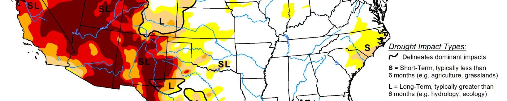
In the South, short-term precipitation shortfalls and declining soil moisture levels led to some degradation of conditions in areas of Arkansas and Oklahoma that have largely missed out on recent rainfall events. Out West, dry conditions prevailed across most of the region this week. However, some beneficial rainfall was observed across isolated areas of the Southwest in association with the remnants of Hurricane Nora.
South
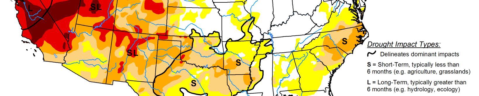
After the passing of Hurricane Ida, the region experienced some drying out this week as compared to the previous week’s deluge. For the past 30-day period, above-normal precipitation levels (130% to 300% of normal) have been observed across southeastern Louisiana, Mississippi, and much of Tennessee. Conversely, precipitation has been below normal across much of Arkansas, Texas, and Oklahoma during the past month, leading to expansion of areas of Abnormally Dry (D0). This includes around Tulsa, Oklahoma, which observed only 0.85 inches (normal 3.64 inches) for the month of August and no precipitation to date for September. Elsewhere, some minor improvements were made in an area of Moderate Drought (D1) in the Trans-Pecos region in the vicinity of Big Bend National Park where the Chisos Basin observing station reported 10.42 inches of rain (340% of normal) for the month of August. Likewise, the Pine Springs Guadalupe National Park observing station in the Trans-Pecos logged 8.98 inches (560% of normal) during August 2021. For the week, average temperatures were above normal (3 to 9 deg F) across Texas, Oklahoma, and western portions of Louisiana and Arkansas while areas to the east were 1 to 6 deg F below normal.
Midwest
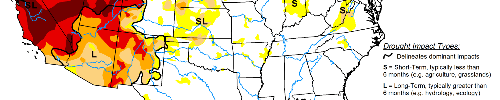
On this week’s map, widespread one-category improvements were made in drought-stricken areas in northern Iowa and western Minnesota, which received another round of beneficial precipitation this week. In these areas rainfall accumulations ranged from 1 to 4 inches. In areas of northern Iowa and southern Minnesota, percentage of normal precipitation has ranged from 150% to 300% of normal for the last 30-day period. Likewise, light rainfall this week led to trimming back of small areas of Moderate Drought (D1) in northwestern Illinois and west-central Indiana. Conversely, dry conditions during the past 90-day period led to slight expansion of areas of Severe Drought (D2) in northern Wisconsin as well as areas of Moderate Drought (D1) in Upper Peninsula Michigan.
High Plains
On this week’s map, areas of the region—including eastern portions of North Dakota, South Dakota, Nebraska, and Kansas—saw isolated improvements in response to continued rainfall activity. The heaviest rainfall in the region was observed in eastern Kansas where accumulations ranged from 2 to 7 inches, while areas further to the north in Nebraska and the Dakotas received 1-to-4-inch accumulations in isolated areas. For the last 30-day period, the percentage of normal precipitation has ranged from 100% to 300% of normal across a widespread area of the Central and Northern Plains. However, isolated pockets of dryness have persisted—particularly in western portions of the region that have not benefited from the recent rainfall events. According to the USDA for the week ending September 5, the percentage of topsoil in North Dakota rated short to very short was 63%, while neighboring South Dakota was rated 66% short to very short.
West
For the week, most of the region continued to experience dry conditions, although some residual moisture from Hurricane Nora worked its way into the Southwest leading to some isolated shower activity. On this week’s map, improvements were made in isolated areas of Arizona, New Mexico, and Utah where recent monsoonal rainfall has continued to improve drought conditions on a shorter-term basis. For the monsoon season (to date), some impressive rainfall totals have been observed in areas of southern and central Arizona and New Mexico as well as in areas of Utah. In Arizona, Tucson is currently having its 3rd wettest monsoon season on record with 12.41 inches (as of September 7), Flagstaff 10.35 inches (4th wettest), Payson 13.06 inches (2nd wettest), and Las Cruces, New Mexico 5.06 inches (3rd wettest). Elsewhere in the region, much of California, western Great Basin, Pacific Northwest, and the Northern Rockies have experienced drier-than-normal conditions during the past 90-day period. In Washington, drought and associated precipitation deficits dating back to the springtime, combined with extreme summer heat, have severely impacted the state’s wheat crop which is reportedly had its lowest output since 1973. According to the USDA, the percentage of topsoil rated short to very is as follows: Washington 100%, Oregon 89%, Idaho 75%, Montana 93%, Wyoming 70%, and California 85%. According to the Natural Resources Conservation Service (Sept 1), reservoir storage levels were below normal across all the western states except for Washington state (data not yet available for Montana).
Related Articles