Recent rainfall improves drought conditions in areas of High Plains, Midwest and South

This U.S. Drought Monitor week saw deterioration in drought-related conditions on the map across areas of the West, including California, Oregon, Washington, Utah and Montana. Moving into dry season, California is expecting drought impacts to intensify during the summer months as snowpack runoff is forecast to be below normal and reservoir storage levels at the state’s two largest reservoirs (Lake Shasta and Lake Oroville) are at 48% and 41% of average, respectively. In response to the deteriorating conditions, Gov. Newsom expanded the coverage of his recent drought emergency declaration to include an additional 39 counties statewide.
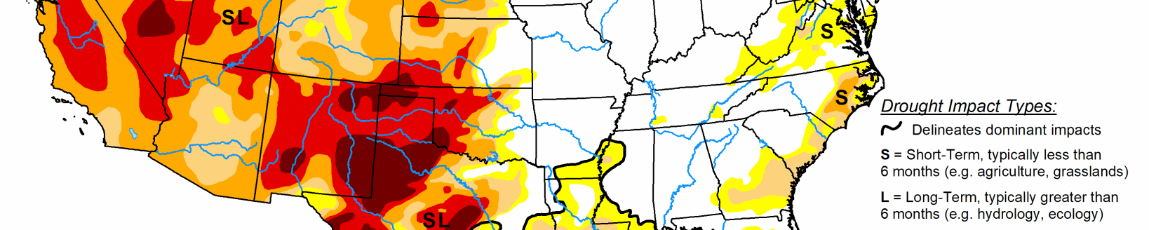
In the High Plains, portions of eastern Colorado and Wyoming saw improvement in drought conditions in response to recent rainfall events and improvement in soil moisture levels. In the Midwest and Northeast, beneficial rainfall during the past two weeks has helped reduce areas of drought on the map. In the South and Southeast, heavy rainfall impacted portions of the region during the past several weeks, leading to reductions in areas of drought in response to improved soil moisture and streamflow levels.
High Plains
On this week’s map, areas of the region—including Colorado and Wyoming —saw improvements, including a reduction in areas of Extreme Drought (D3), Severe Drought (D2), and Moderate Drought (D1) in response to rainfall during the past week and above-normal precipitation during the past 30-to-60-day period. During the past 60 days, the percentage of normal precipitation has been about 150% to 300% of normal.
Moreover, NASA SPoRT is showing soil moisture levels (0 to 10 cm depth) ranging from the 70th to the 98th percentile. Conversely, abnormally dry soils and areas of dry vegetation are being observed in far western portions of Colorado and Wyoming. In terms of streamflow activity, 7-day average streamflows are much below normal (less than 10th percentile) across much of western Colorado, southwestern Wyoming, and northern portions of North Dakota. Average temperatures for the week were mainly below normal (2 to 12 degrees F) with the greatest negative departures observed in the Dakotas. According to the latest (May 10) USDA North Dakota Crop Progress and Condition report, topsoil across the state was rated 52% very short and 28% short with subsoil moisture supplies rated 52% very short and 29% short. In Colorado, reservoir storage levels statewide (end of April) are below normal at 85% of average compared to 104% of average last year. Storage levels were notably below normal in the San Miguel, Dolores, Animas, and San Juan Basins at 57% of average compared to 95% of average last year at the same time. In terms of NOAA NCEI’s climatological rankings, North Dakota observed its driest 6- and 9-month periods on record. On a climate-division level, western Colorado’s Climate Division 2 (Colorado Drainage) observed its driest April on record, as well as its driest 12-month period on record.
South
Across portions of the region, the active pattern continued with significant rainfall accumulations observed in portions of eastern Texas, Louisiana, and Mississippi where 7-day totals ranged from 2 to 8 inches. According to the U.S. Geological Survey, 7-day average streamflows were above normal across much of the region—particularly in southeastern Texas and southern Louisiana where streamflow percentiles were greater than the 90th percentile. On the map, isolated rainfall activity (1 to 2 inches) this week led to some minor improvements in southern and north-central Texas, whereas portions of the Texas Panhandle and the Trans-Pecos region of western Texas saw some deterioration in drought-related conditions and an expansion of areas of drought on the map. In west-central and northern Oklahoma, short-term precipitation deficits and areas of below-normal soil moisture led to a slight expansion of areas of Abnormally Dry (D0) on the map. For March and April, precipitation across the South Climate Region was slightly above normal (40th wettest). However, at the state level, Louisiana observed its 8th wettest April on record with the cities of Baton Rouge and New Orleans observing their 2nd and 5th wettest April, respectively.
Midwest
On this week’s map, there were reductions in areas of Abnormally Dry (D0) across portions of Iowa, Illinois, Indiana, and Ohio, as well as improvements in areas of Moderate Drought (D1) in northern Michigan where rainfall has been above normal during the past 30-to-60-day period and 7-day average streamflows are running in the normal to above normal range. Conversely, streamflow activity in southern Michigan is running well below normal levels and NASA SPoRT is showing topsoil moisture below the 10th percentile. The dryness in this area is also showing up in the Vegetation Drought Response Index (VegDRI) product. Average temperatures for the week were below normal across the entire region (4 to 12 deg F). According to the NOAA NCEI’s climatological rankings, Iowa observed its 13th driest April on record and the last 5-month period was the 9th driest on record for Michigan.
West
Out West, approximately 84% of the region is currently in drought on the map with 47% in Extreme Drought (D3) or Exceptional Drought (D4). On this week’s maps, drought intensified in areas of California, Oregon, Washington, Montana, and Utah as dry conditions continued this week across most of the region. In California, areas of Exceptional Drought (D4) expanded on the map in the southern and eastern Sierra in response to very poor snowpack conditions during the 2020–2021 Water Year. In the southern Sierra, the Tulare Basin 6-Station Precipitation Index for the Water Year to Date (WYTD) is currently showing its 2nd driest Water Year on record—only slightly ahead of the driest year on record back in the 1976–1977 season. In the central Sierra, the San Joaquin 5-Station Index is currently observing its 3rd driest WYTD on record and in the northern Sierra, the Northern Sierra 8-station Index its 2nd driest WYTD on record. In response to deteriorating conditions across much of California, Governor Newsom expanded the drought emergency declaration to cover 39 additional counties across the state, including counties in the Sacramento and San Joaquin River watersheds. In Arizona, the U.S. Forest Service is reporting a drought-related die-off of juniper trees across portions of central and northern Arizona in Prescott and Kaibab National Forests. In addition, reports are coming in from northern Arizona that ranchers on the Coconino Plateau have been hauling water for cattle and wildlife for the past month because dirt stock tanks are completely dry. In northwestern Oregon, areas of Severe Drought (D2) and Moderate Drought (D1) expanded on this week’s map as streamflow and soil moisture levels continue to degrade. In southwestern Montana, areas of Moderate Drought (D1) expanded on the map in response to below-normal precipitation during the past 30-to-90-day period, low streamflows, and reductions in irrigation allotments. In the Upper Colorado River Basin, May through July streamflow volumes are forecasted to be less than 60% of average and inflow into Lake Powell is forecasted to be 28% of normal. According to NOAA NCEI, the West Climate Region (California and Nevada) had its 6th driest April on record and its 3rd driest October through April period on record. Likewise, the Northwest Climate Region (Idaho, Oregon, and Washington) had its 3rd driest April on record. In the Southwest Climate Region (Four Corners states), the last 12- and 24-month periods were both the driest on record for the region. At the state level, California observed its 6th warmest April on record and Arizona observed its 10th warmest.