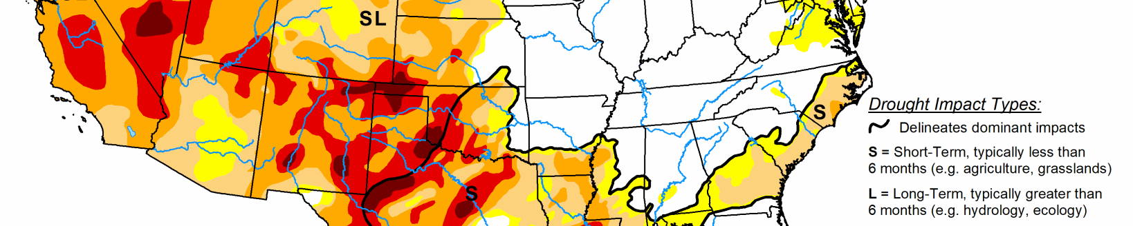
The U.S. experienced the extremes this week, with expansion of drought in the West, a robust Southwest Monsoon in the Southwest, a tropical storm making landfall in the Southeast, and extreme flooding in southeastern Texas. In the West, mid-level ridging has resulted in much above-normal temperatures for the western third of the CONUS, exacerbating drought conditions in the Pacific Northwest, northern Great Basin, Northern Rockies, and along the Front Range. Above-normal temperatures also pushed into the northern High Plains, warranting further deterioration of drought conditions in locations where rainfall remained below-average for the week. The central and eastern Corn Belt was a battle ground of sorts, with some locations seeing improvement with this week’s heavy rainfall, while other locations missed out, warranting some degradation due to antecedent dryness.
New Mexico and West Texas saw targeted reductions in drought coverage due to heavy precipitation associated with the robust Southwest Monsoon. In the eastern U.S., Tropical Storm Elsa made landfall and moved up the East Coast leaving in its wake a large swath of more than 2 inches of rainfall, with several locations receiving 5 to 10 inches of rainfall. The extra-tropical transition of Elsa warranted moderate drought (D1) removal along the Virginia/North Carolina border with 1-category improvements elsewhere along Elsa’s path up the East Coast. Frontal activity prior to Elsa’s passage warranted improvements to interior areas of the Northeast. Fire risk remains high across the West.
High Plains
The western half of the High Plains Region experienced above-normal average temperatures this week underneath a mid-level ridge, while the eastern half experienced below-normal average temperatures, associated with increased cloud-cover and heavy rainfall for several locations. Improvements were mainly designated to the Middle Missouri River basin, encompassing parts of eastern South Dakota and northeastern Nebraska, which received more than 2 inches of rainfall (more than 1 inch above-normal for the week). Elsewhere in the Dakotas, Nebraska, and Kansas, below-normal precipitation coupled with antecedent dryness warranted several 1-category deteriorations. In the western half of the High Plains Region, deteriorations were more a function of above-normal temperatures helping to exacerbate ongoing drought conditions in the Eastern Rockies and along the Front Range. Furthermore, this region is void of snowpack due to the below-normal rainy season in the West leading up to this period of above-normal temperatures since Spring, which has caused further depletion of soil moisture, stream flows, and ground water in many locations.
South
A localized area of low pressure brought severe flooding to much of southeastern Texas, with many locations in and around the Houston metro area receiving 10 to 15 inches of rainfall. Some of the precipitation associated with this system made it farther westward, resulting in 1-category improvements (D0 and D1) along the Rio Grande. Western Texas, and extending into New Mexico, is experiencing improved ground conditions with this week’s rainfall, but also with antecedent conditions related to the early onset and robustness of the Southwest Monsoon, warranting 1-category improvements in the Trans-Pecos region and western parts of the Panhandle. Farther east in the Tennessee Valley, D0 coverage was reduced for many locations receiving 2 inches or more of rainfall. However, where the heavier amounts were not observed, short-term deficits continue to mount, with parts of northeastern Tennessee experiencing an expansion of abnormally dry (D0) conditions, with a small area deteriorating to moderate drought (D1) conditions, where 90-day deficits have increased to around 6 inches.
Midwest
Much of this week’s rain fell over the central and eastern Corn Belt and parts of the central Great Lakes. Where the heaviest rainfall was not observed, 1-category degradations were in order. This was particularly the case across much of central and northern Minnesota, where soil moisture percentiles have dropped to below the 5th percentile, D2 to D4 30 to 90-day SPIs depict the greatest coverage, and several USGS stations are reporting 7 to 28-day average stream flows that are below the 10th percentile. Farther south, Iowa and northern Illinois experienced a mix of improvement and deterioration based on where the heaviest precipitation fell or did not fall, respectively. This region has become a bit of a battleground in that respect, due to the antecedent, longer-term dryness (several locations experiencing 25 to 50 percent of normal precipitation in the last 90 days) and the recent heavy rains cutting into some of those deficits. Across the remainder of the central and eastern Corn Belt and the central Great Lakes, this week’s rainfall warranted 1-category improvements to D0 (abnormally dry) to D2 (severe drought) areas across the lower peninsula of Michigan and D0 areas in the Ohio Valley.
West
Extreme, record-breaking heat leading up to this week has resulted in rapid deteriorations in drought conditions across the Pacific Northwest, northern Great Basin, and Northern Rockies. Although the largest positive temperature anomalies shifted southward into the Desert Southwest and Four Corners Region this week, above-normal temperatures persisted across in the northwestern CONUS, resulting in continued degradations of drought conditions from the Pacific Northwest eastward to central Montana. A small area of improvement was warranted in northeastern Montana, where 1 to 2 inches of rainfall resulted in modest improvements to soil moisture and short-term SPIs. Farther southward in New Mexico, the robust Southwest Monsoon has resulted in drastic improvements in recent weeks. This week is more of the same, with several 1-category improvement across central and eastern portions of the state. In some cases, moisture has seeped several feet into the soils, at least down to 200 cm (per NASA SPoRT and ground reports). Improved shallow ground water conditions also support the improved depiction this week. However, fire concerns remain across the West as a whole, as there have been nearly 40 new wildfires reported since July 10 (89 as of July 14).