Northern areas receive heavy precipitation; high winds cause blowing dust and wildfires farther south
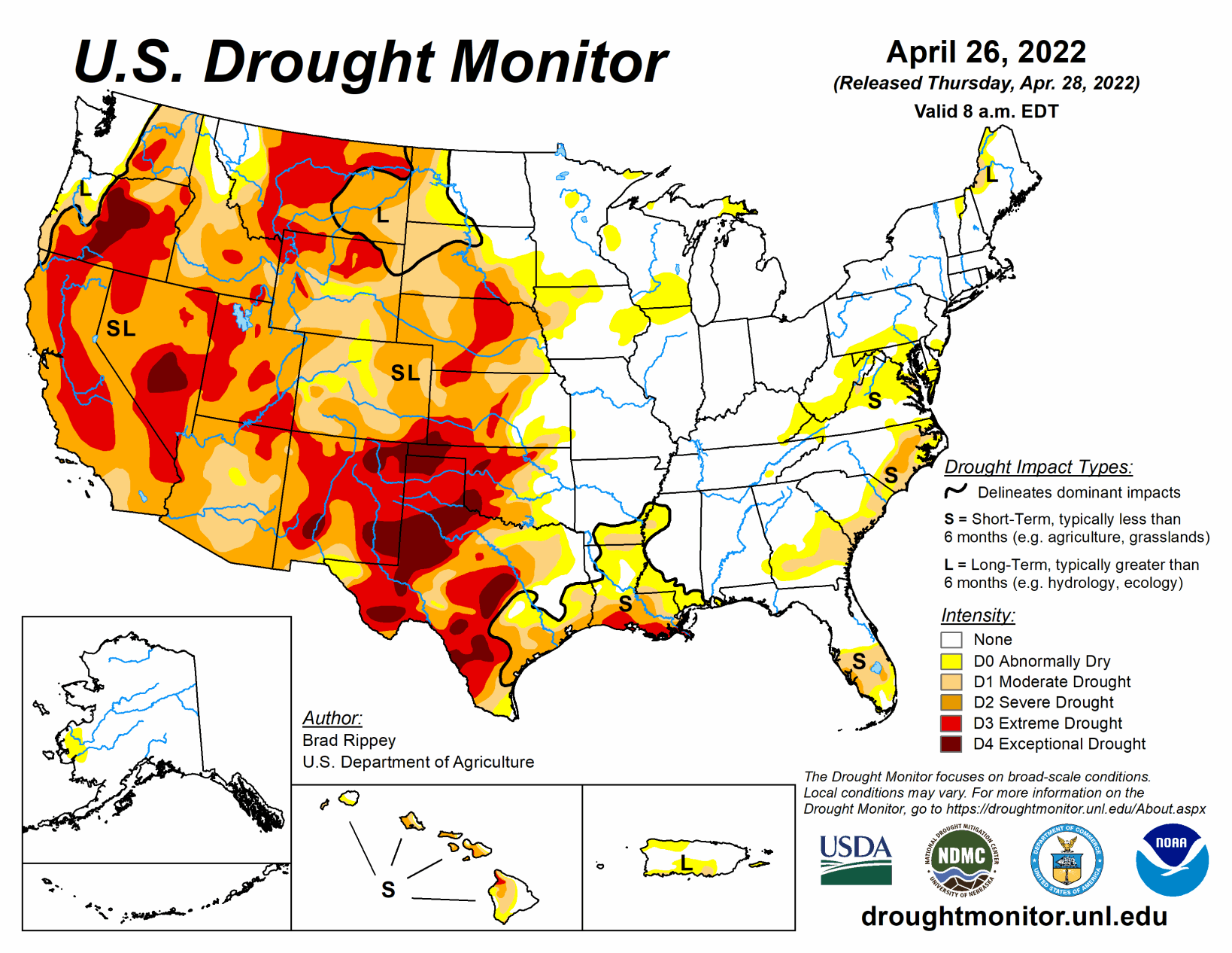
Only about 10 days after a powerful, winter-like storm struck the northern Plains, a similar system delivered another round of heavy precipitation and high winds. With the more recent storm, which primarily unfolded on April 22 and 23, heavy snow was focused across a smaller area, primarily blanketing western North Dakota, southeastern Montana, northwestern South Dakota, and portions of Wyoming.
Farther south, high winds again raked the central and southern Plains and the Southwest, resulting in blowing dust and fast-spreading wildfires. Across the southern High Plains’ hardest-hit drought areas, hot, windy weather sapped any remaining soil moisture and further stressed rangeland, pastures, and winter grains.
Meanwhile, a few severe thunderstorms dotted the Plains and upper Midwest, leading to localized wind and hail damage. The greatest concentration of severe weather occurred on April 22 from South Dakota to northern Texas. In contrast, little or no precipitation fell during the week across the nation’s southwestern quadrant, leading to further drought intensification. As the drought-monitoring period ended (on the morning of April 26), a significant rain event was winding down across parts of southern and eastern Texas.
South
The region remained split between critically dry conditions on the High Plains of Oklahoma and Texas and wet conditions just to the east. During the drought-monitoring period, the axis of heaviest rain stretched from northeastern Texas into northern Arkansas, with additional rainfall maxima in parts of southern and eastern Texas. Those rains led to targeted, one-category improvements in the drought depiction, with highly localized two-category changes. Meanwhile, the region’s driest areas continued to experience deteriorating conditions, including a broad expansion of exceptional drought (D4), amid periods of extreme heat, high winds, and blowing dust. Temperatures reached 100°F—mainly on April 20 and 21—in parts of the south-central U.S., extending to the Texas-Oklahoma border near Childress (100°F on April 21) and Wichita Falls, Texas (99°F on April 20).
In western Texas, peak gusts April 22 were clocked to 73 mph in Lubbock and Dalhart. On April 24, Texas led the country in several drought-related categories, according to the U.S. Department of Agriculture, including topsoil moisture rated very short to short (86%, tied with New Mexico) and winter wheat rated in very poor to poor condition (78%). On the same date, nearly half (48%) of Oklahoma’s wheat was rated very poor to poor.
Midwest
Widespread precipitation, accompanied by cool conditions, led to general reductions in the coverage of abnormal dryness (D0) and moderate drought (D1). In fact, a pesky area of D1, stretching across portions of eastern Iowa, northern Illinois, and southern Wisconsin, was finally eliminated by soaking rainfall. Drought (D1) was also completely removed from northern Minnesota, following another round of heavy precipitation. Daily-record rainfall amounts included 1.16 inches (on April 22) in Rockford, Illinois, and 1.49 inches (on April 23) in International Falls, Minnesota. By April 24, topsoil moisture was rated one-quarter to one-half surplus in all Midwestern States except Iowa, led by Illinois (49% surplus), according to the U.S. Department of Agriculture.
In addition, only 7% of the intended U.S. corn acreage had been planted by April 24, the least amount sown on that date since 2013. Corn seeding was at least 10 percentage points behind the 5-year average planting pace in Illinois, Iowa, Kentucky, Minnesota, and Missouri. Cold weather was a factor in the slow planting place, along with wet conditions. On the morning of April 26, daily-record low temperatures in Iowa included 19°F in Sioux City and 22°F in Cedar Rapids.
High Plains
For the second week in a row, significant precipitation fell across parts of the northern Plains. Heavy snow blanketed western North Dakota, southeastern Montana, northwestern South Dakota, and parts of Wyoming, helping to further improve soil moisture. Still, by April 24, the U.S. Department of Agriculture reported topsoil moisture was rated at least one-half very short to short in each of the region’s states except North Dakota (26% very short to short, down from 39% the previous week).
Elsewhere in the region, topsoil moisture rated very short to short ranged from 53% in South Dakota to 82% in Nebraska. Still, parts of the eastern Dakotas have become very wet, with runoff enhanced by melting snow and rain falling on partially frozen soils. Following the latest storm, moderate to major flooding developed in the Red River Valley, extending northward from near Grand Forks, North Dakota. By April 27, the Red River at Oslo, Minnesota, was more than 11.5 feet above flood stage and less 10 inches below the April 2009 high-water mark. Farther south, however, drought continued to gradually expand and intensity, amid windy, mostly dry conditions and rapid temperature fluctuations.
In Nebraska, daily-record highs for April 22 soared to 91°F in Sidney and 97°F in Valentine and North Platte, followed just 3 days later by a daily-record low of 14°F in Sidney. By April 24, more than one-quarter of the winter wheat in each of the region’s major production states was rated in very poor to poor condition, led by Colorado (47%) and Kansas (36%).
West
Conditions were nearly identical those observed the previous week, with beneficial precipitation falling across the northern tier of the region and windy, dry weather dominating the Southwest. Given the Southwest’s low humidity levels, high winds, and drought-cured vegetation, two active wildfires—the Hermits Peak and Cooks Peak Fires—charred more than 50,000 acres of vegetation apiece in northeastern New Mexico.
Northeast of Flagstaff, Arizona, the Tunnel Fire—ignited on April 17—scorched nearly 20,000 acres of vegetation and destroyed more than 50 structures. At times, impressively high winds raked the Southwest, raising dust and fanning flames. On April 22 in New Mexico, wind gusts in Gallup, Farmington, Las Vegas, and Raton were clocked to 70, 72, 73, and 80 mph, respectively.
By April 24, according to the U.S. Department of Agriculture, New Mexico led the nation—tied with Texas—with topsoil moisture rated 86% very short to short. By the 26th, Tucson, Arizona, reported a daily-record high of 100°F—only the fourteenth observance of triple-digit heat on record during April in that location. Tucson’s only earlier readings of 100°F or higher occurred on April 19-21, 1989, and April 22-23, 2012.
Deterioration was common across the Southwest, with extreme to exceptional drought (D3 to D4) broadly expanding in New Mexico and moderate to severe drought (D1 to D2) increasing in coverage across parts of Arizona and Colorado. Farther north, however, periods of precipitation continued from northern California and the Pacific Northwest to the northern Rockies.
Related Articles