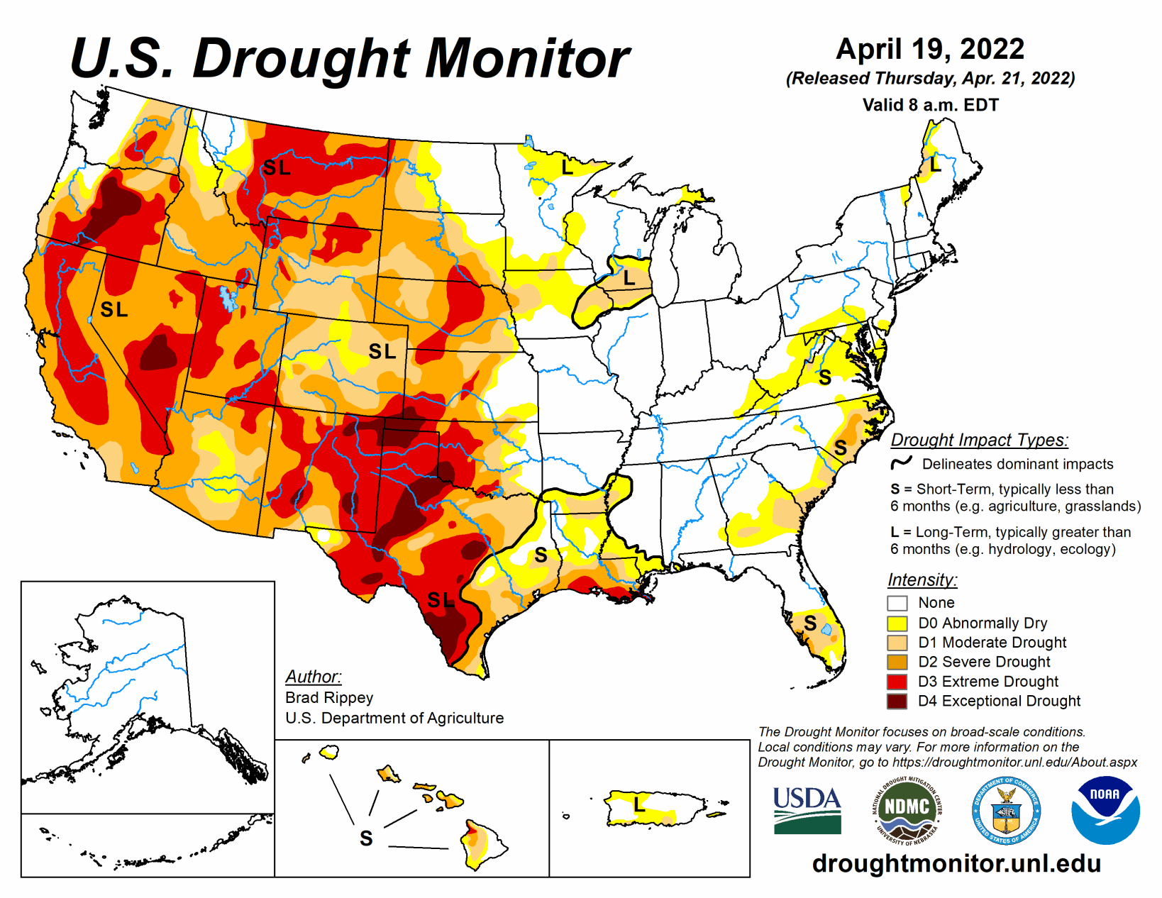
The drought-monitoring period, which began on the morning of April 12 and ended early April 19, featured a powerful spring storm delivering significant, late-season snow from the Cascades and Sierra Nevada to the northern Plains. High winds and blizzard conditions accompanied the snow, especially across the northern Plains. Farther south, drought conditions worsened across portions of the central and southern Plains and the Southwest, amid windy, dry conditions.
At times, winds raised dust and contributed to the rapid spread of several wildfires, including the 6,159-acre McBride Fire, which destroyed well over 300 structures after being ignited on April 12 in Ruidoso, New Mexico.
Significant rain fell in other areas, including parts of the Midwest and Northeast. Warm weather prevailed for much of the period in the South and East, while a harsh cold snap engulfed the northern Plains and Northwest. In fact, an extended spell of chilly weather broadly covered the western U.S., as well as the upper Midwest.
South
Heavy rain fell across roughly the eastern half of the region, resulting in extensive reductions in the coverage of abnormal dryness (D0) and moderate to extreme drought (D1 to D4). According to a network of volunteer (CoCoRaHS) observers, month-to-date rainfall totals of 6 to 8 inches or more are common across the region. April 1-19 rainfall officially reached 8.51 inches in Arkadelphia, Arkansas; 7.64 inches in Hattiesburg, Mississippi; and 6.70 inches in Troy, Alabama.
In stark contrast, moderate to exceptional drought (D1 to D4) continued to worsen in many areas west of a line stretching across eastern sections of Oklahoma and Texas. On April 17, Texas led the U.S. (tied with Montana) with topsoil moisture rated 85% very short to short, according to the U.S. Department of Agriculture. Also, on the 17th, more than three-quarters (81%) of the winter wheat in Texas, along with 80% of the oats and 76% of the rangeland and pastures, were rated in very poor to poor condition. Nationally, 37% of the winter wheat was rated in very poor to poor condition on that date, highest at this time of year since April 14, 1996, when 43% of the crop fell into those two categories.
On the southern High Plains, episodes of blowing dust or smoky skies have been common this spring; in Lubbock, Texas, visibility was sharply reduced in dust on April 12, when a southwesterly wind gust to 60 mph was reported. The south-central U.S. has also experienced periods of extreme heat, with McAllen, Texas, reporting highs of 100°F or greater on April 6, 11, and 13. McAllen’s high of 109°F on April 6 set a monthly record (previously, 107°F on April 26, 1984, and April 27, 2014). However, there have also been cool spells, with Dalhart, Texas, posting a daily-record low of 22°F on April 14.
Midwest
Cool, damp conditions have resulted in widespread spring fieldwork delays. Several daily-record lows were set on April 19, with temperatures falling to 19°F in Cedar Rapids, Iowa; 26°F in Quincy, Illinois; and 32°F in Cape Girardeau, Missouri. The day before, on April 18, daily-record snowfall totals included 1.6 inches in Indianapolis, Indiana, and 2.3 inches in Dayton, Ohio. Among Midwestern States, corn planting had begun by April 17 only in Kentucky (6% sown, versus the 5-year average of 16%) and Missouri (4% sown, versus 12% on average). On the same date, topsoil moisture ranged from 40 to 60% surplus in Illinois, Indiana, Michigan, and Ohio, according to the U.S. Department of Agriculture. Still, there were a few pockets of abnormal dryness (D0) and moderate to severe drought (D1 to D2) mainly across the upper Midwest, with general improvement noted in many areas over the last week.
High Plains
A winter-like storm pounded North Dakota and portions of neighboring states, delivering much-needed moisture but disrupting travel and stressing livestock. Across the remainder of the High Plains, however, windy, dry weather raised dust, resulted in fast-spreading wildfires, and led to a broad increase in the coverage of abnormal dryness (D0) and moderate to extreme drought (D1 to D3).
Temperatures briefly plunged across the central Plains, threatening the already drought-stressed winter wheat crop. Denver, Colorado, registered 10°F on April 13, a record for the date, followed the next day by daily-record lows of 4°F in Sidney, Nebraska, and 9°F in Colby, Kansas. By April 17, the U.S. Department of Agriculture reported that topsoil moisture was rated more than 60% very short to short in each of the region’s states except North Dakota, led by Nebraska (84% very short to short). On the same date, nearly half (48%) of the winter wheat in Colorado was rated in very poor to poor condition. One-fifth to one-third of the wheat was rated very poor to poor in Kansas (31%), Nebraska (27%), and South Dakota (22%).
West
A classic La Niña regime has developed in recent weeks, providing beneficial moisture across northern California and the Pacific Northwest, eastward to the northern Rockies. At the same time, dry, often windy weather has affected the nation’s southwestern quadrant. As a result, deterioration has been observed in parts of the Southwest, particularly in New Mexico. According to the U.S. Department of Agriculture, Montana (85%) led the West in topsoil moisture rated very short to short on April 17, followed by New Mexico (80%).
New Mexico, in addition to the McBride Fire, has been dealing with several other blazes, including the 7,573-acre Hermits Peak Fire, which started as a prescribed fire northwest of Las Vegas on April 6 before escaping containment. More recently, the Crooks Fire has been actively burning south of Prescott, Arizona, with numerous evacuations in effect.
Farther north, however, the recent spell of cool, damp weather has generally boosted topsoil moisture, has locally improved water-supply prospects, and has provided a late-season boost in high-elevation snowpack. Snow briefly fell at lower elevations, too, with the airport in Portland, Oregon—which had never experienced a measurable April snowfall—receiving 1.9 inches on April 11-12. The airport’s previous latest snow had fallen on March 25, 1965, when 0.3 inch fell. Downtown Portland, hit with 2.0 inches of wet snow on April 11, also set a record for its latest accumulation (previously, 0.1 inch on April 10, 1903). Measurable snow fell in Great Falls, Montana, each day from April 11-17, totaling 12.2 inches. Farther west, the first-ever measurable April snow fell at the agricultural experiment station in Wenatchee, Washington. Incredibly, the Wenatchee Experiment Station received 10.4 inches of snow on April 14, boosting its month-to-date total to 13.1 inches. A neighboring station, the Wenatchee Water Plant, received a storm total of 5.4 inches, breaking its April 1935 record of 0.5 inch. The net effect of the Northwestern precipitation was to result in slight trimming of moderate to extreme drought (D1 to D3). However, there was often a fine line between areas that received beneficial precipitation and those that did not.