Great Plains received beneficial rains
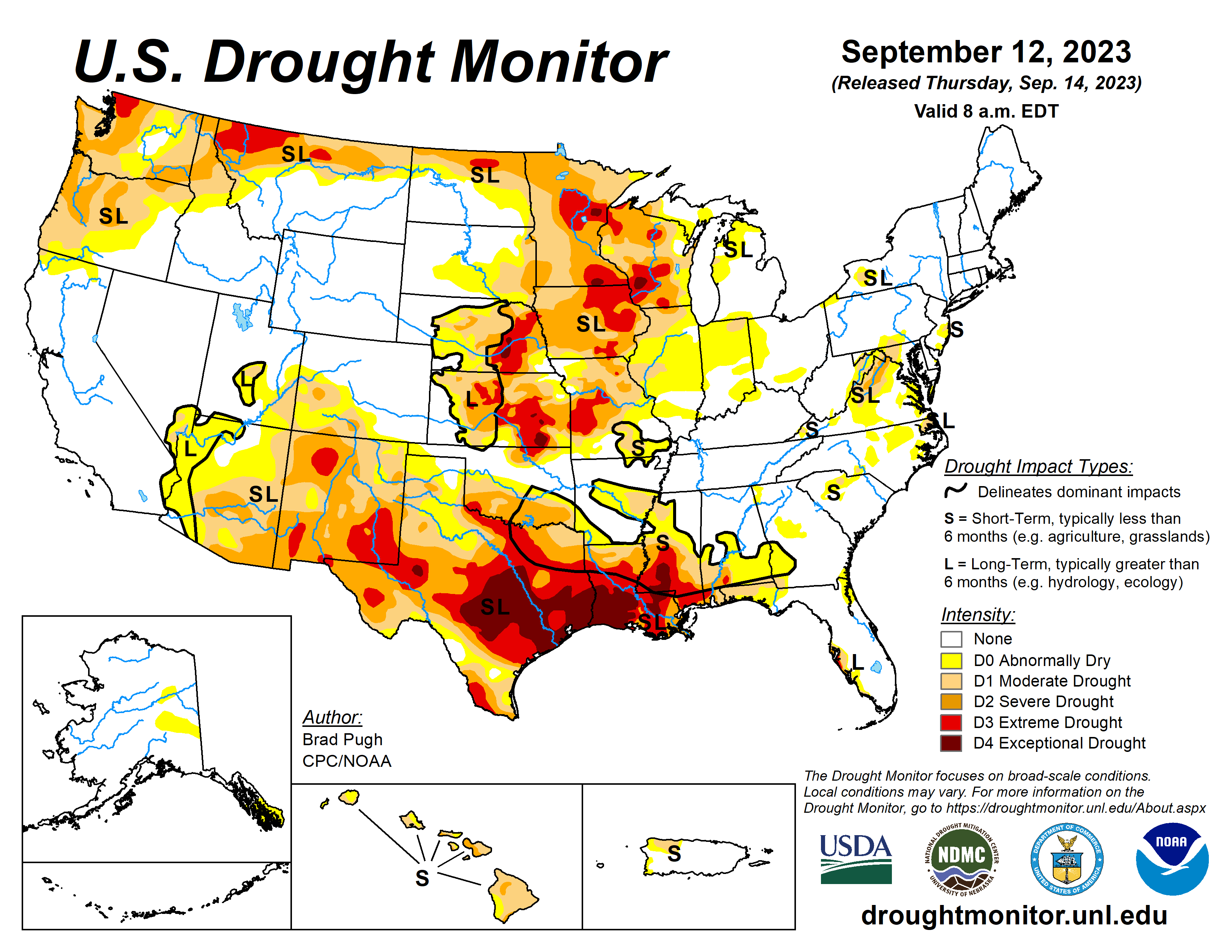
Widespread precipitation amounts of 0.5 to 2 inches (locally more) were observed across much of the Great Plains, Upper Mississippi Valley and East. Improvements were made to areas that received the heaviest amounts.
In the wake of a cold front, Sept. 5 to 11 temperatures averaged near to slightly below normal for the northern Great Plains and Upper Midwest. Farther to the south, above-normal temperatures continued across the southern Great Plains and western Gulf Coast.
Since early August, persistent excessive heat coupled with a lack of adequate rainfall led to a rapid onset and intensification of drought from Texas eastward to the Lower Mississippi Valley and parts of the Southeast. Monsoon rainfall began to decrease throughout the Four Corners region and Southwest during early September, while seasonal dryness prevailed along the West Coast.
South
The rapid onset and intensification of drought continues throughout central and southern Mississippi. According to the NCEI, numerous counties in the southern half of Mississippi had their driest August on record. Many of those counties have received less than 0.5 inch of precipitation during the first ten days of September.
Along with this dryness, persistent above-normal temperatures have led to high evapotranspiration rates and worsening impacts to agriculture and high fire danger. Little change was made to Louisiana this week since the previous USDM map matches up well with the indicators (NDMC short-term blend and soil moisture). Many areas received at least a 0.5 inch of precipitation this past week.
A 1-category degradation was warranted for southeastern Oklahoma and parts of Texas due to the prolonged excessive heat this summer and lack of adequate precipitation. The expansion of extreme (D3) to exceptional (D4) drought across central and eastern Texas was based largely on the 90-day SPEI and soil moisture indicators.
Despite heavier rainfall (more than 1 inch) across west-central Texas, soil moisture indicators, 90-day SPEI, and NDMC’s drought blends support a continuation of D2+ levels of drought. More than 1.5 to 2 inches of precipitation prompted a 1-category improvement to northwestern Oklahoma and the northeastern Texas Panhandle.
Midwest
A warm start to September and lack of adequate precipitation during the late summer resulted in a 1-category degradation to parts of the Midwest. The largest 30-day precipitation deficits (more than 3 inches) exist across much of Iowa, southern Minnesota, and southwestern Wisconsin.
Conversely, heavy precipitation supported a 1-category improvement across northeastern Minnesota and northwestern Wisconsin. Abnormal dryness (D0) and moderate short-term drought (D1) was expanded across parts of Illinois, Indiana, northern Kentucky, and Ohio due to increasing short-term precipitation deficits.
The one exception was northeastern Illinois which received more than 2 inches of rainfall recently and led to the elimination of D0. Extreme drought (D3) was expanded across southwestern Missouri, based on 120-day to 6-month SPIs and soil moisture.
High Plains
Heavy rainfall (1.5 to 3 inches, locally more) prompted a 1-category improvement to southwestern Kansas along with parts of Nebraska. Also, NDMC’s drought blends were a factor in these improvements.
Conversely, 30-day SPEI and soil moisture supported small degradations across eastern parts of Kansas. Worsening soil moisture indicators led to an expansion of severe drought (D2) across northeastern North Dakota.
West
Much of the West was status quo this week as Monsoon rainfall begins to decrease during September and this is a drier time of year for California and the Pacific Northwest. However, low 28-day streamflows and SPEI at various time scales led to an expansion of severe drought (D2) across coastal Washington and northwestern Oregon.
Looking ahead
During the period of Sept. 14 to 18 moderate to heavy precipitation (0.5 to 2 inches, locally more) is forecast for the southern Great Plains. Hurricane Lee is forecast to track near New England and could bring heavy precipitation to coastal New England. Elsewhere, across the eastern and central U.S., mostly dry weather is forecast.
Brad Pugh is with the National Oceanic and Atmospheric Administration and Climate Prediction Center.


