Early fall moisture welcome news
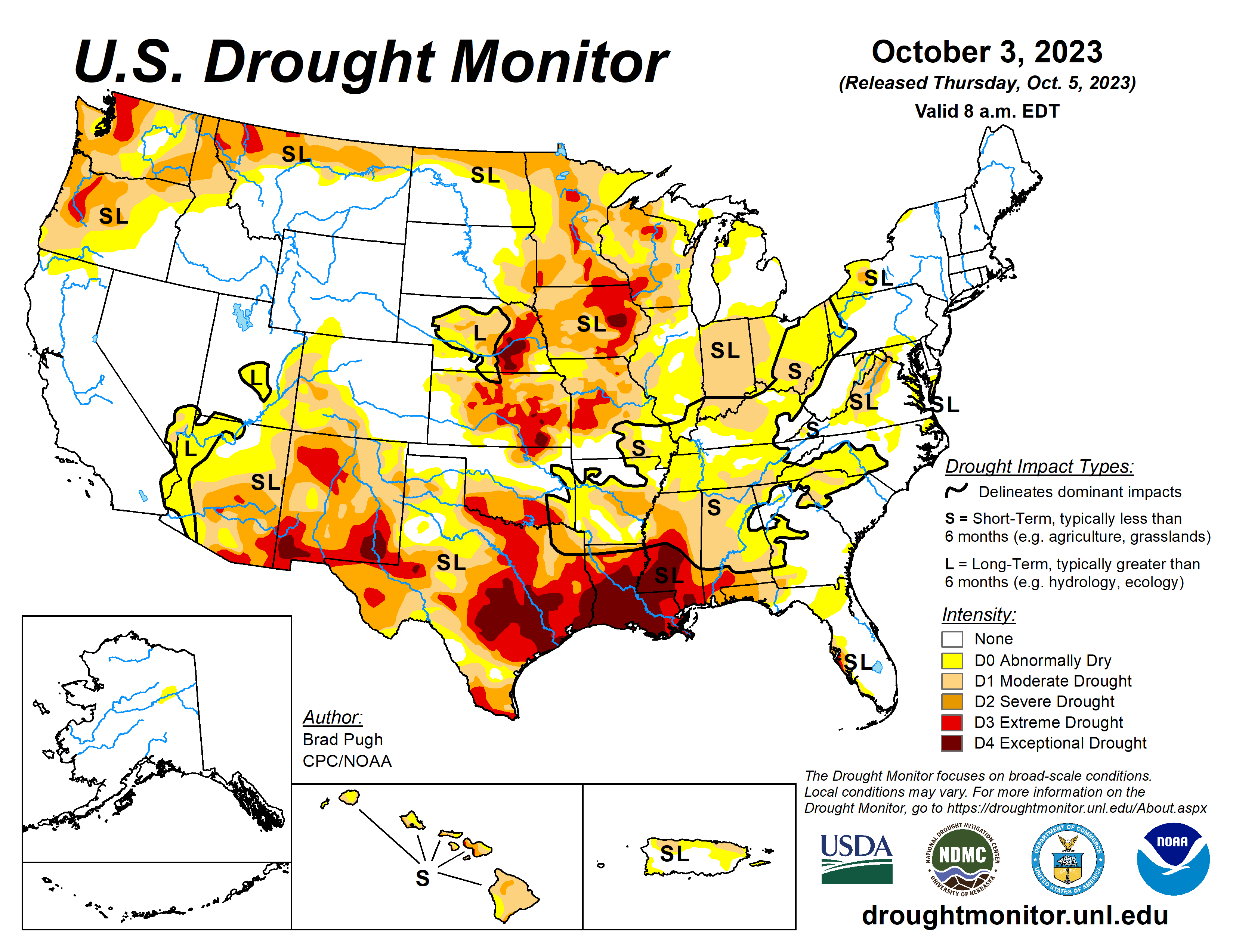
The rapid onset and intensification of drought continued across the South with drought expanding northeast from the Lower Mississippi Valley to the Tennessee Valley and Southern Appalachians.
A drier-than-normal September led to an expansion of abnormal dryness (D0) and moderate short-term drought (D1) across the Upper Ohio Valley and eastern Corn Belt. Drought of varying intensity persists across the Middle to Upper Mississippi Valley and parts of the Great Plains.
However, heavy rainfall at the beginning of October resulted in improvement for the southern High Plains. A suppressed 2023 Monsoon led to intensifying drought across Arizona and western New Mexico.
South
Severe (D2) to exceptional (D4) drought persists across much of Mississippi and Louisiana, while drought of varying intensity affects the Southern Great Plains. Heavy rainfall (more than 2 inches) on Oct. 2 supported a 1-category improvement across the Oklahoma Panhandle and western Texas.
Based on state recommendations and consistent with the NDMC drought blends, the extreme drought (D3) was slightly reduced across western Texas.
Midwest
A mix of degradations and improvements were made this past week across the Middle to Upper Mississippi Valley, Ohio Valley, and Corn Belt. The largest areas of degradation were focused across Indiana and Ohio. Many areas have received less than 25% of their normal precipitation during the past 30 days and soil moisture indicators continue to decline.
Based on NDMC’s short to long-term blends and soil moisture, extreme (D3) and exceptional (D4) drought was expanded across eastern Iowa. Parts of Kentucky, southern Illinois, Minnesota, and Wisconsin had a 1-category improvement after heavy rainfall (more than 1.5 inches) the previous week.
High Plains
Increasing 30 to 60-day deficits along with support from SPIs at various time scales and the NDMC’s short-term drought blend, a 1-category degradation was made to northeastern Kansas and southeastern Nebraska.
Despite a mostly dry week across southern South Dakota, a reassessment of current indicators such as NDMC’s drought blends supported a decrease in abnormal dryness (D0) and moderate drought (D1) in that area.
A 1-category degradation was made to northwestern Colorado, based on SPEIs at multiple time scales along with support from soil moisture and vegetation indicators.
West
Following the drier-than-normal Monsoon, a 1-category degradation was warranted for parts of Arizona and western New Mexico.
Heavy rainfall (more than 2 inches) on Oct. 2 led to a 1-category improvement for parts of eastern New Mexico. NDMC’s short-term blend and soil moisture supported a 1-category degradation in eastern Utah. Extreme drought (D3) was improved to severe drought (D2) in parts of northern Montana based on indicators dating back 12 months.
In addition, 28-day average streamflows are above the 5th percentile in northwestern Montana.
Looking ahead
During Oct. 5 to 9, a strong cold front is forecast to progress across the central and eastern U.S. Precipitation amounts of an inch or less are expected across the Ohio Valley with heavier amounts (locally more than 2 inches) for southeastern Oklahoma and eastern Texas.
A major temperature pattern change is likely during this 5-day period as cooler-than-normal temperatures overspread the central and eastern U.S.
The Climate Prediction Center’s 6- to 10-day outlook from Oct. 10 to 14 favors below-normal precipitation across the central to southern Great Plains and Southwest. Below-normal temperatures are favored for most of the Northeast, while above-normal temperature probabilities are enhanced from the West Coast to the Mississippi Valley.
Brad Pugh is with the National Oceanic and Atmospheric Administration and Climate Prediction Center.
Related Articles


