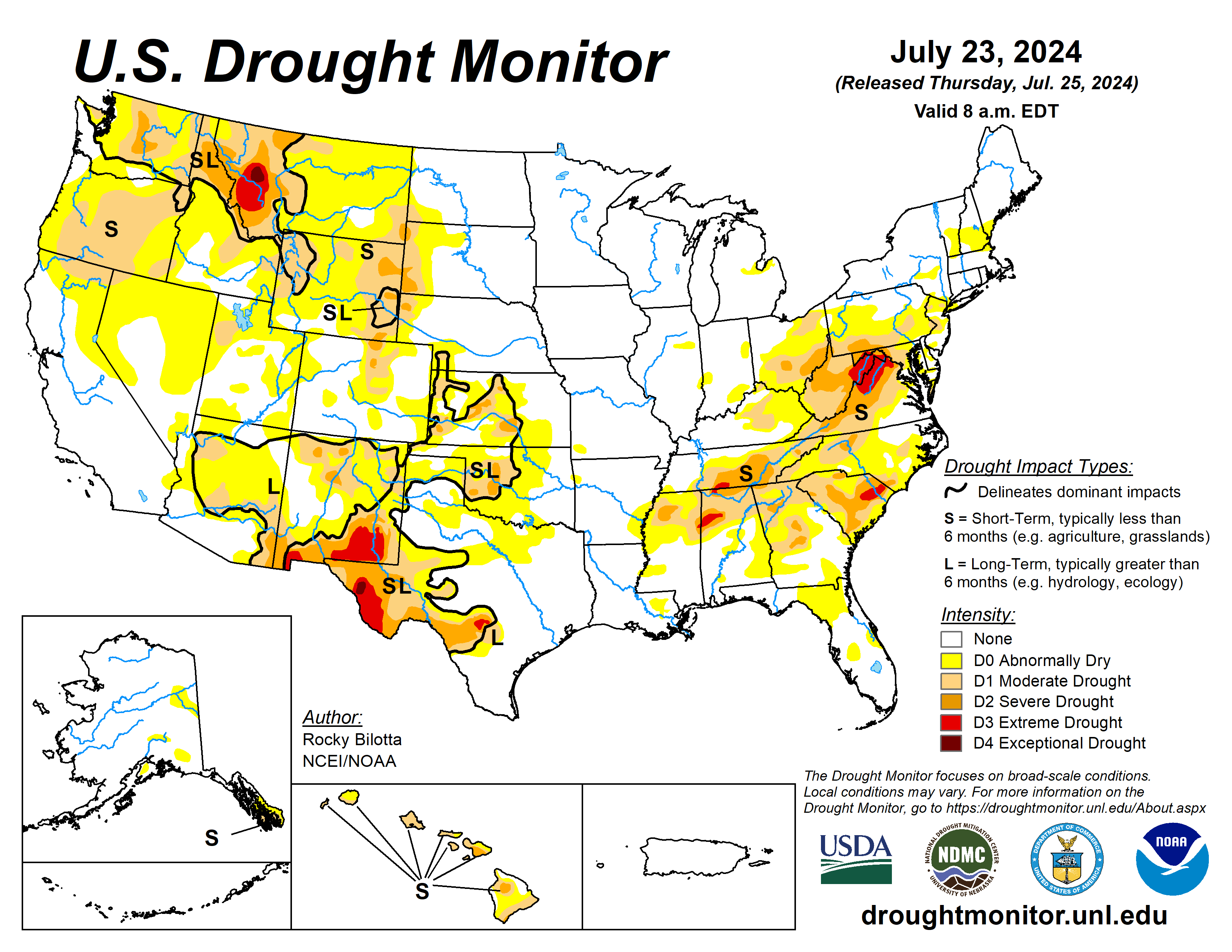
Over the past week, a major heatwave brought warmer-than-normal temperatures to much of the West, with departures ranging between 3 to 12 degrees Fahrenheit above normal across much of the region.
Near-normal to cooler-than-normal temperatures were observed from the central Rockies to the Great Lakes, with departures ranging between 3 to 9 degrees below normal. Precipitation varied across the contiguous United State. Monsoonal moisture brought heavy precipitation and flash flooding to parts of the Southwest, while a lingering frontal boundary brought daily thunderstorms, heavy rainfall and flash flooding across much of the Southeast and Mid-Atlantic.
The most widespread improvements were made in the Southeast, as well as eastern portions of the Southwest and across much of western Texas, where above-normal precipitation amounts were observed. Conversely, dry conditions resulted in degradations across much of Hawaii and the Pacific Northwest, as well as southern portions of the Northeast and in parts of the central Plains, and other parts of the West.
Drought and abnormal dryness also expanded or intensified in the Ohio Valley, western High Plains, and in New England.
The U.S. Drought Monitor is jointly produced by the National Drought Mitigation Center at the University of Nebraska-Lincoln, the U.S. Department of Agriculture and the National Oceanic Atmospheric Administration. (Map courtesy of NDMC.)
South
Dry conditions continued across much of the northern portions of the South, while heavy precipitation fell across much of central Texas and in parts of northern Arkansas, with areas reporting rainfall totals greater than 600% of normal. Abnormal dryness was removed from northern Arkansas.
Moderate to extreme drought were improved across much of central Texas.
Conditions continued to deteriorate in parts of western Texas, where precipitation totals were 5% to 25% of normal for the past month. Exceptional drought was introduced into the Trans-Pecos region of Texas. Temperatures were below-normal across much of the South, while departures of 1 to 6 degrees above normal were observed across parts of western Texas. The expansion and intensification of drought categories were based on short-term SPI/SPEI, reservoir levels, streamflow and soil moisture data.
Midwest
Much of the Midwest remained free of drought and abnormal dryness this week, while average temperatures were well below normal across much of the region with departures ranging between 1 to 9 degrees below normal.
Precipitation was also below normal across much of the Midwest, resulting in the expansion and intensification of drought in eastern parts of the region.
High Plains
Precipitation fell across much of the region this week, which was enough to prevent large areas of degradation but not enough to warrant large improvements. The heaviest rainfall amounts fell across much of eastern Colorado, reporting rainfall totals up to 400% of normal, resulting in the improvements of abnormal dryness and the removal of moderate drought from the region.
Conversely, conditions continued to deteriorate in parts of northern Kansas. Moderate to severe drought were expanded into central Kansas. Heavy precipitation amounts were also reported in central Nebraska and central South Dakota but were already free of drought and abnormal dryness.
Precipitation was below-normal across the western portions of the region, resulting in the expansion and intensification of drought. Severe drought was added western South Dakota and Nebraska, and expanded in eastern Wyoming. Moderate drought also introduced in southwest Nebraska this week, while abnormal dryness was expanded in the area. Much of the region remains free of drought and abnormal dryness this week.
West
Average temperatures were well above normal across much of the West this week. Temperatures ranged between 3 to 9 degrees above normal across much of the region, while northern portions of the region observed temperatures up to 12 degrees above normal this week. Precipitation fell across much of the region but amounts were mostly below-normal for the region.
The heaviest precipitation amounts were measured over parts of New Mexico. Above-normal precipitation (up to 6 inches), along with cooler temperatures, resulted in the removal of exceptional drought from southeast New Mexico and improvements to extreme drought, severe drought, moderate drought and abnormal dryness across eastern and southern portions of the state. Warmer temperatures and below-normal precipitation resulted in the introduction of exceptional drought in western Montana, as well as the expansion of drought in other parts of Montana.
Looking ahead
During July 23 to 27, dangerous heat is expected to continue through the midweek across much of the West, with high temperatures reaching the 90s and 100s and ranging between 5 to 15 degrees above normal. The strong ridge, extending from the Southwest U.S. into west-central Canada, which produced hazardous heat from the West into the northern High Plains, should begin to weaken and begin to push eastward ahead of a Pacific upper low tracking into western Canada and trailing trough that will settle near the West Coast.
Monsoonal conditions will promote daily episodes of showers and storms over the Four Corners states and into the Great Basin under and near upper ridging over that part of the country. Meanwhile, one or more wavy fronts will be on the leading side of Great Lakes into southern Plains mean troughing aloft, leading to multiple days of rain and thunderstorms with areas of heavy rainfall from the southern Plains.
The Climate Prediction Center’s six- to 10-day outlook (valid through Aug. 1) favors increased probabilities for above-normal temperatures are forecast for much of the contiguous U.S., while below-normal temperatures are likely across Texas.
Rocky Bilotta is with the National Oceanic Atmospheric Administration and National Centers for Environmental Information.


