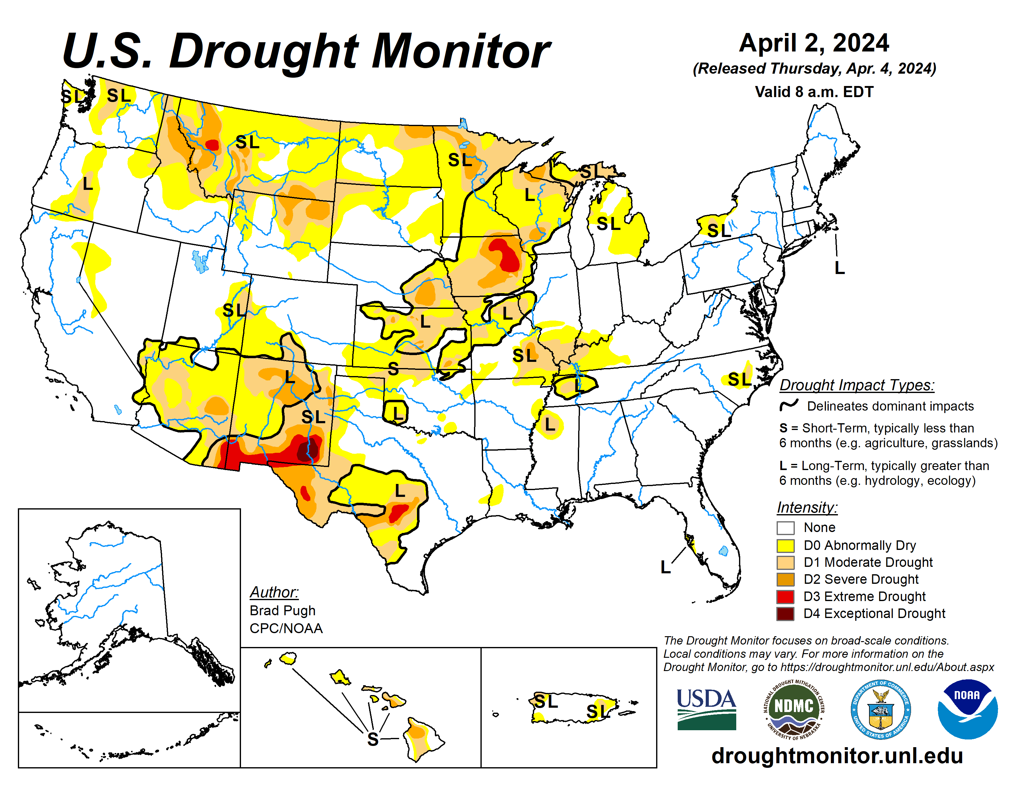
An active early springtime pattern continued through late March and into the beginning of April. A pair of low-pressure systems and trailing cold fronts tracked across the east-central contiguous United States.
A swath of 1 to 3 inches of precipitation supported improvements extending from parts of the Midwest to southeastern Kansas and northeastern Oklahoma. However, moderate drought was introduced to the lower Ohio Valley which has missed out on precipitation during the late winter and early spring.
Increasing short-term dryness and periods of enhanced winds led to expansion of abnormal dryness and moderate drought in southwestern Kansas, northwestern Oklahoma, and western Texas.
March was relatively wet across Arizona where additional improvements were warranted before a drier time of year sets in later this spring. Below-normal snowpack supported an increase in D1 across the northern Cascades of Washington. The seven-day (March 26 to April 1) temperatures averaged below normal across the western and north-central contiguous U.S.
The U.S. Drought Monitor is jointly produced by the National Drought Mitigation Center at the University of Nebraska-Lincoln, the U.S. Department of Agriculture and the National Oceanic Atmospheric Administration. (Map courtesy of NDMC.)
South
Major drought relief, associated with El Nino, occurred this past winter across the lower Mississippi Valley. However, there remains a lingering long-term drought across parts of western Tennessee and northern Mississippi.
On April 1, locally heavy rainfall (more than 1.5 inches) resulted in small improvements to northeastern Oklahoma.
Farther to the west across the southern High Plains, short-term dryness is increasing. Enhanced winds, elevated wildfire risk, and blowing dust have been quite frequent the past few weeks due to low pressure systems. Based on 30 to 60-day SPI, an expansion of abnormal dryness and moderate drought was warranted for parts of northwestern Oklahoma and western Texas.
Midwest
Heavy precipitation (1 to 3 inches, locally more) prompted 1-category improvements throughout southern Michigan, Ohio, Indiana, Illinois, Missouri, and eastern Iowa. However, the lower Ohio Valley continues to miss out on late winter and early spring precipitation which led to an expansion of moderate drought for this region.
A 30- to 60-day SPI, soil moisture, and 28-day streamflows support the current drought depiction across parts of the lower Ohio and middle Mississippi Valleys.
Following last week’s broad improvements across the upper Mississippi Valley, no changes were made this week with much of this region receiving less than 0.5 inch of precipitation, liquid equivalent.
Despite the improvements the past two weeks throughout much of the Midwest, long-term drought indicators continue to support varying levels of drought intensity including extreme drought in northeastern Iowa. According to U.S. Department of Agriculture’s National Agricultural Statistics Service, 59% of Iowa topsoil moisture is rated as short to very short.
High Plains
The northern to central Great Plains along with the central Rockies remained either status quo this week or had a 1-category improvement. Locally heavy precipitation (more than 1 inch) led to targeted improvements across southeastern Kansas.
Lighter precipitation (0.25 to 1 inch) supported minor improvements to South Dakota. Based on SPIs at various time scales along with snow water equivalent close to average, improvements were necessary for parts of northern Colorado and southern Wyoming. A 30-day SPEI and GRACE-based soil moisture supported a large increase in abnormal dryness across southwestern Kansas along with a slight expansion of moderate drought to the west of Wichita.
West
Multiple low-pressure systems and enhanced onshore flow resulted in above-average precipitation for much of Arizona, Utah, Nevada, and California from March 26 to April 1. According to the California Department of Water Resources on April 2, snow water equivalent (SWE) averaged at or slightly above normal for the Sierra Nevada Mountains.
A relatively wet March and widespread precipitation amounts of 0.5 to 1 inch, liquid equivalent, this past week supported improvements for Arizona. Given the recent precipitation, the drought impact was modified to reflect only long-term drought for most of Arizona. This region will be re-evaluated next week and additional revisions may be warranted.
Looking ahead
During the next five days (April 4 to 8), drier weather is forecast to overspread the Midwest and East behind a cold front. Another low-pressure system is forecast to track inland to the West with another round of rain and high-elevation snow from California east to the north-central Rockies. Later on April 8, precipitation is expected to develop across the southern Great Plains and lower Mississippi Valley.
The Climate Prediction Center’s six- to 10-day outlook (valid April 9 to 13xvb) depicts a pattern change by mid-April with a drying trend for the West. Below-normal precipitation is favored for this region along with the northern Great Plains.
Elsewhere, across the central to southern Great Plains, Midwest, and East, above-normal precipitation is more likely. Above-normal temperatures are favored for much of the lower 48 states except for parts of New Mexico and western Texas where increased below-normal temperature probabilities are forecast.
Brad Pugh is with the National Oceanic Atmospheric Administration and the Climate Prediction Center.


