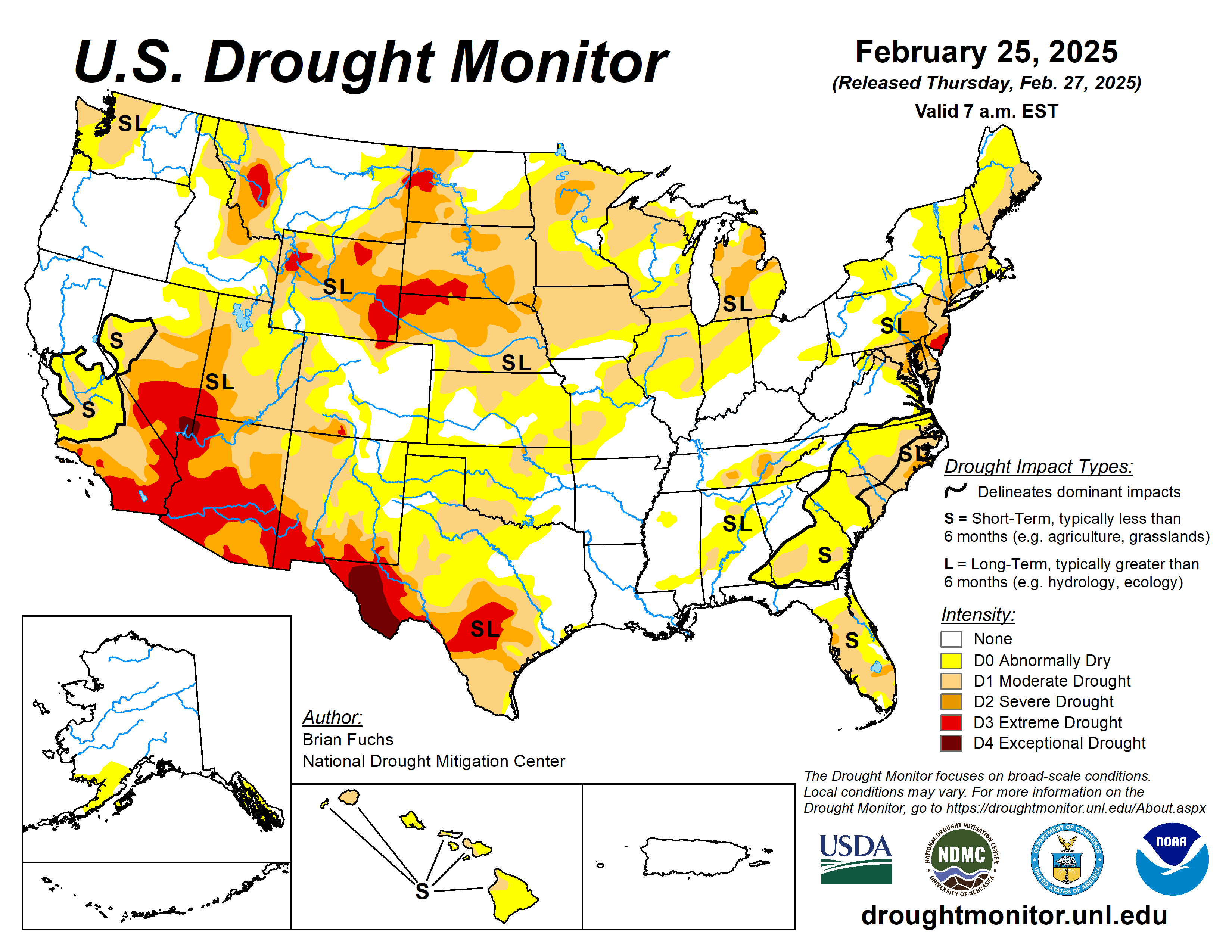
With limited precipitation during the week, most of the country was dry after an active week prior.
The week was highlighted by the wild temperature swings from the first part of the period to the end. The current period started off with temperatures that were well below normal over much of the country and ended with temperatures that were well above normal. Valentine, Nebraska, had an observed low temperature of minus 33 degrees Fahrenheit on Feb. 20, and this rebounded to 69 degrees on Feb. 25, a swing of 102 degrees over that five-day span.
Precipitation was greatest over the coastal areas of the Pacific Northwest as well as along the Gulf Coast and Florida. In southern Louisiana, 4 to 6 inches of rain was common for the region. Even with cold temperatures over much of the eastern half of the country, the West was normal to slightly above normal for the week.
The U.S. Drought Monitor is jointly produced by the National Drought Mitigation Center at the University of Nebraska-Lincoln, the U.S. Department of Agriculture and the National Oceanic Atmospheric Administration. (Map courtesy of NDMC.)
South
It was a colder-than-normal week over the region with temperatures in the 10 to 20 degrees below normal range over the entire area. The greatest rain occurred across the coastal areas of east Texas, Louisiana and portions of northeast Oklahoma.
The region has been dry over much of the winter after a few very wet weeks in the autumn. The short-term data are picking up the dryness that also was prevalent prior to the wet November. As the dryness persists, moderate drought was expanded into more of southwest Oklahoma and into northern and central Texas.
Abnormally dry conditions were expanded over much of southern Oklahoma and north Texas. Due to ongoing hydrological drought issues in south Texas, drought expanded this week with more moderate, severe and extreme drought conditions. Abnormally dry conditions were improved over east Texas but were not removed completely due to some lingering dryness being observed at longer timescales.
The recent rains allowed for the removal of the abnormally dry conditions over southern Louisiana and some improvements in southern Mississippi, where both moderate drought and abnormally dry conditions were improved.
Midwest
It was a mostly dry week over the region with some precipitation in areas of Missouri.
Nearing the end of February, the winter has been dry over much of the region, which has allowed for expansion of moderate drought over Missouri, Iowa and Minnesota. Abnormally dry conditions were expanded in Missouri and Minnesota.
High Plains
Light precipitation was measured from eastern Wyoming into Kansas and Nebraska as well as in portions of western North Dakota and the plains of eastern Montana.
Most other areas were dry. With the dry conditions, moderate drought levels were expanded over southern Kansas along with additional abnormally dry conditions being shown.
West
A very divided region with wetter-than-normal conditions in the north and zero precipitation in the south. The most abundant precipitation was along the coastal areas of Washington and Oregon and into Idaho and western Montana.
In Wyoming, abnormally dry conditions improved over the southwest part of the state while moderate, severe and extreme drought conditions improved over the northern and western parts of the state. Montana had improvements to moderate, severe and extreme drought over eastern portions of the state in response to the improving indicators. In Colorado, some abnormally dry conditions improved in the northcentral areas while they were expanded in the south.
Moderate and severe drought expanded in the south along with a new pocket of extreme drought due to the long-term drought indicators and the poor snow season to date. In New Mexico, moderate drought expanded over the west and abnormally dry conditions expanded in the east.
Looking ahead
Over the next five to seven days, it is anticipated that the best chances of precipitation will be over the West Coast and into the Great Basin, the Mid-Atlantic into the Northeast, the upper Midwest and across the Ozark plateau and into portions of the southern Plains.
Temperatures are anticipated to be above normal over most of the Plains and into the Southeast with coastal areas of the West below normal. The greatest departures from normal are expected over the Southern Plains with departures of 10 to 13 degrees above normal.
The 6-to 10-day outlooks show the high probability of above-normal temperatures over the upper Midwest and from south Texas and along the Gulf Coast as well as Alaska.
The best chances of cooler-than-normal temperatures reach the Four Corners region. Most of the country will have above-normal chances of above-normal precipitation.
Brian Fuchs is with the National Drought Mitigation Center.


