Colorado weather outlook a mixed bag
Senior climate and water resource scientist with Lynker, Becky Bolinger told attendees of the recent Colorado State University Livestock & Forage Growers Update the water year has been an interesting one so far.
Bolinger, former Colorado assistant state climatologist is no stranger to forecasts and outlooks, and she discussed what the water year has looked like since October 2024.
“Most of the state has experienced a warmer October through February, especially as we look down towards the San Luis Valley and across the Western Slope, where we see ranking in the top 10 warmest for that time period,” she said. “Statewide rank is 21st warmest out of the 130 years.”
As for precipitation in that same time period, rankings were near the middle—68th driest or 63rd wettest—however you look at it, she said. Some parts of Colorado have been wetter, while others have been dry. By shifting the months in the water year, it will paint a little bit different picture though, she said.
“Really, a bulk of that extreme warmth came from the 2024 portion of the water year,” she said. “Looking at the precipitation rankings just for our winter months—December, January, February—once we drop out October and November, those wet rankings that we saw in southern Colorado and southeast Colorado disappears.”
She said most of the remaining moisture from those 2024 weather events are all but gone.
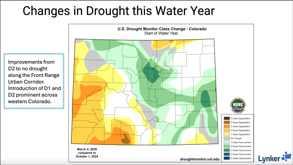
“If you look at conditions now on the west slope, all of western Colorado shows up much drier, with a couple of areas around Montrose County and Delta County, and down towards Mineral and Hinsdale, with their record driest winter out of those 130 years,” she said. “So, a very different situation, depending on how you look at it.”
The snowpack—the amount of water stored in the snow at each individual station averaged over a basin—is troubling as of March 10. Parts of the state are mostly near normal levels for this time of year. In the Central mountains in the Gunnison Basin, the Arkansas Basin is only about 70% to 90% of average snowpack.
“And then as we move further south for the Rio Grande basin and the San Miguel and San Juan Basin, we’re seeing below normal, below that 70% of average mark for snow pack conditions,” Bolinger said. Drought is showing in some of those areas too.
“Currently we have almost 8% of our state is in D2 or D3 drought,” she said.
Outlook
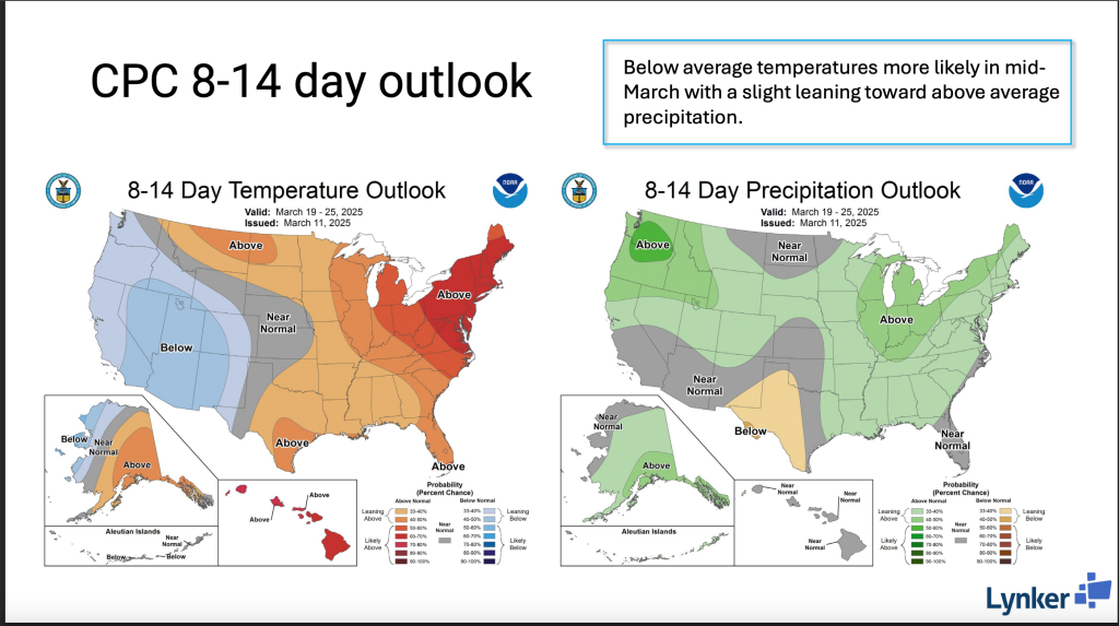
At the time of the March 10 webinar, Bolinger said the Climate Prediction Center’s 8-to-14-day outlook showed areas of the southwestern United States leaning towards below average temperatures.
“That creeps up over the Four Corners and through western Colorado, but it’s just a slight leaning towards that below average temperature, with closer to normal temperatures expected for the central and eastern part of the state,” she said.
The precipitation for the same time period showed the best chances for above average precipitation in the Pacific Northwest, over the Great Lakes region and over Colorado. She didn’t take much stock in that prediction.
Seasonally in March, April and May, Bolinger is expecting above average temperatures and believes it could impact the San Juan Mountains and could mean faster snow pack melting. For most of northeastern Colorado, the seasonal outlook is uncertain about what the temperature pattern is going to be.
As for precipitation, the outlook is showing a “bullseye” showing up over the Four Corners region and extending into southwest Colorado.
“So really this is looking at there is more confidence that most of Colorado is going to have a dry spring,” she said.
It could be connected to La Nina, Bolinger speculated. Currently conditions point to a weak La Nina, and the CPC forecasts show during March to May there’s either a 35% chance of still being in La Nina or 65% being in neutral conditions.
“As we move through the spring and into summer, the most likely conditions will be neutral, which means that La Nina will continue to weaken and will be replaced by neutral conditions,” she said. “What neutral conditions means is that the tropical Pacific Ocean off the coast of South America does not show those warm anomalies like you would see with an El Nino, or the cold anomalies like you would see with a La Nina.”
That doesn’t really tell Bolinger much about what summer will be like.
“I would say it’s pretty much a dice roll,” she said about summer. “What do you expect to happen in the fall if we’re going to stay in neutral or go into La Nina or go into an El Nino? I would say at this point, it’s really too soon to tell, and we don’t know what to expect at this time.”
Wrap up
In summary, Bolinger expects to see worsening drought over western Colorado, and that’s because with La Nina, that’s consistently the experience. Even with a mid-March weather event, it’s not looking very promising.
“It doesn’t look like after this week’s event, that we’re going to get any more much more help for the southwest portion of our state,” she said. “The summer right now is pretty hard to predict, so unfortunately, I don’t have much say about that, but we will probably have worsening drought in southwest Colorado.”
Kylene Scott can be reached at 620-227-1804 or [email protected].