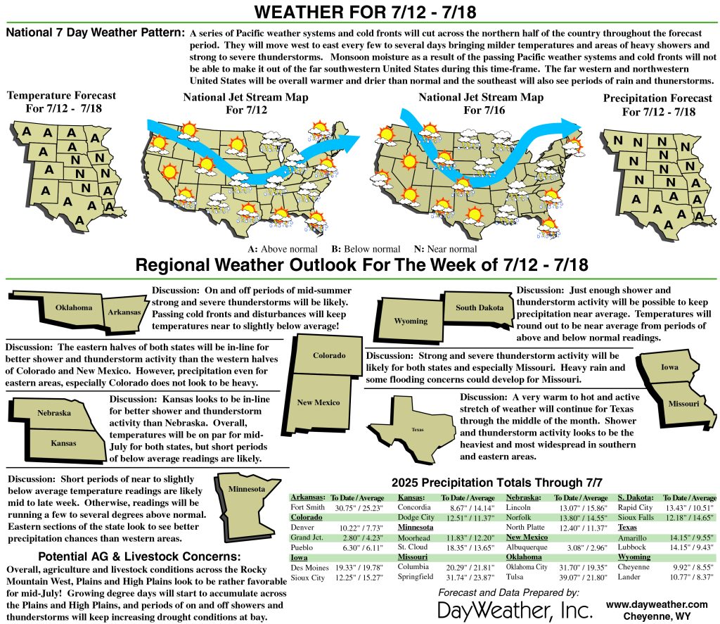
Drought intensity continues to retreat
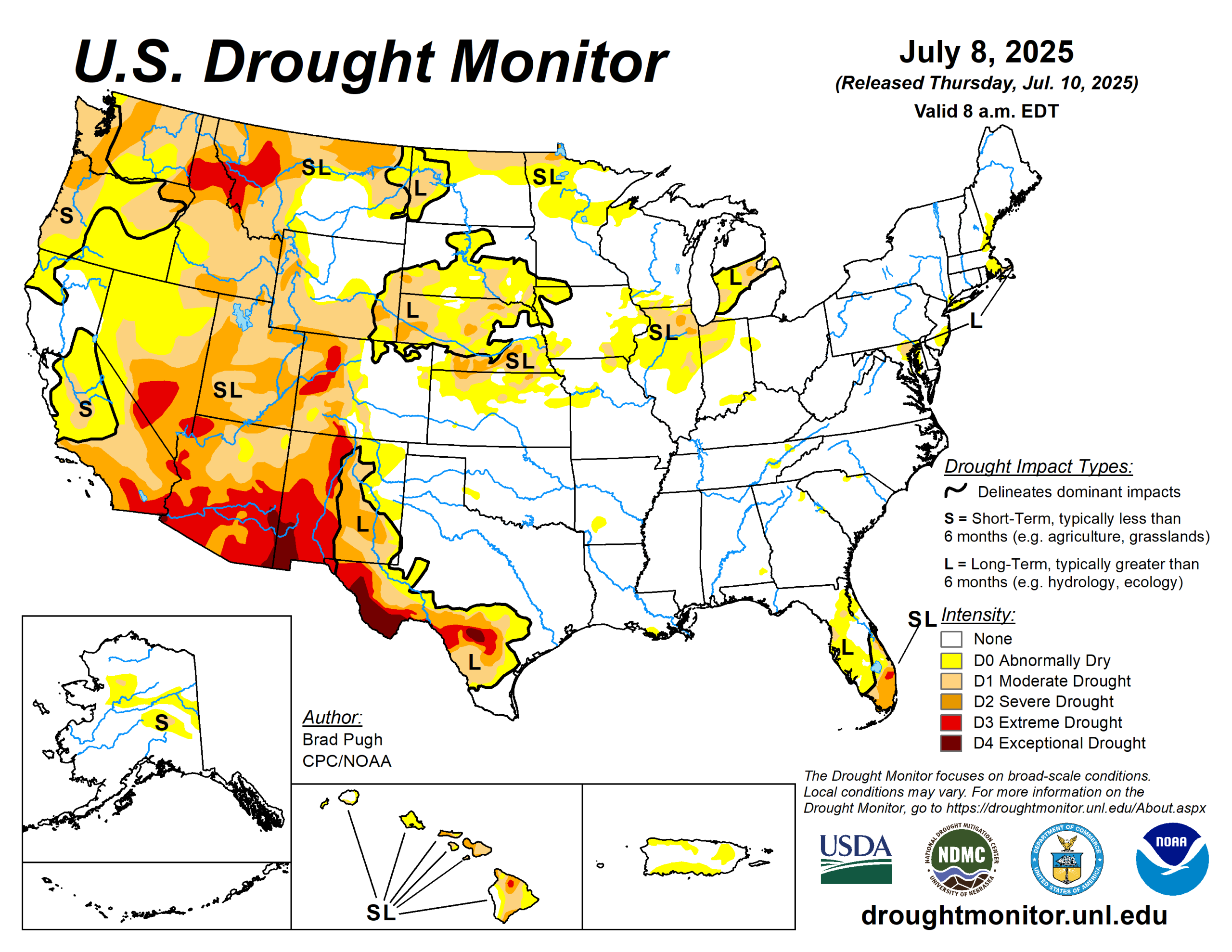
Drought coverage and intensity continued its decline throughout the Great Plains since the spring with additional heavy rainfall during the first week of July.
Despite the extremely heavy rainfall and flash flooding this past week, long-term drought dating back multiple years remains across south-central Texas. Improving drought conditions were made to parts of New Mexico, southwestern Colorado, and Arizona, while drought expanded and intensified across the Pacific Northwest and Northern Intermountain West.
Much of the Corn Belt and Midwest remains drought-free, but a continued lack of adequate precipitation led to worsening drought for northern Illinois. Following another week of summertime thunderstorms with heavy rainfall, drought ended for most of the central to southwestern Florida Peninsula.
Nearly all of the East, Ohio and Tennessee Valleys, and Lower Mississippi Valley are drought-free. The seven-day temperatures (July 1 to 7), averaged 2 to 4 degrees Fahrenheit above normal across the Pacific Northwest, northern Great Plains, Midwest, and New England.
Cooler-than-normal temperatures were limited to the southern Great Plains and portions of the Southwest.
The U.S. Drought Monitor is jointly produced by the National Drought Mitigation Center at the University of Nebraska-Lincoln, the U.S. Department of Agriculture and the National Oceanic Atmospheric Administration. (Map courtesy of NDMC.)
South
A broad one to two-category improvement was made this past week to much of the ongoing long-term drought areas of Texas along with parts of New Mexico. The heaviest precipitation (5 to 10 inches, or more) occurred across the Edwards Plateau and south-central portions of Texas. According to CoCoRaHS gauge measurements from July 1 to 7, precipitation amounts ranged from 12 to 18 inches in eastern Burnet and western Williamson counties of Texas. Although 1- to 2-category improvements were made, a long-term drought dating back multiple years with low groundwater and reservoir levels continue.
Therefore, an area of long-term drought (D1+) was maintained. The Edwards Aquifer Authority’s long-term observation wells at Medina and Uvalde counties remain in extreme (D3) to exceptional (D4) drought levels. Elsewhere, across the southern Great Plains and lower Mississippi Valley, no short-term or long-term drought is designated.
Midwest
Increasing 30 to 60-day precipitation deficits, worsening soil moisture and pasture conditions, and crop stress support a 1-category degradation for much of northern Illinois.
Above-normal temperatures to start July has also led to higher evapotranspiration rates and water demand. Minor degradations were made to parts of northwestern Missouri where short-term precipitation deficits have increased.
Recent heavy precipitation, exceeding 2 inches, led to a 1-category improvement for parts of western Iowa. Significant rainfall (1.5 to 2 inches) supported a 1-category improvement to parts of eastern Iowa and northern Minnesota.
High Plains
Another round of heavy rainfall (1 to 2 inches, locally more) supported a 1-category improvement to parts of the northern and central Great Plains. April through early July is a wet time of year and 90-day precipitation, valid April 9 to July 7, averaged more than 150% of normal for much of the Dakotas, Nebraska, eastern Colorado, and eastern Wyoming.
Conversely, moderate drought (D1) across northeastern North Dakota was expanded westward due to another dry week and above-normal temperatures. The D1 is supported by the 30 to 60-day SPIs along with soil moisture indicators. Eastern Kansas has missed out on the heavy rainfall recently and abnormal dryness (D0) was added to that part of the state.
Although precipitation was not that heavy across southwestern Colorado, enough precipitation along with support from SPIs at multiple time scales and the NDMC drought blends warranted small 1-category improvements.
West
Following recent beneficial precipitation along with timely wetness back to the late spring, improvements were warranted for parts of north-central and eastern Montana.
Drought intensity remained nearly steady for the Desert Southwest although locally heavier Monsoon showers led to a small reduction in extreme drought (D3) for eastern and southern Arizona.
Looking ahead
From July 10 to 14, a cold front is forecast to shift southeast across the central U.S. and provide the focus for thunderstorms. The most widespread, heavy precipitation (more than 1.5 inches) is forecast across the Upper Mississippi Valley and western Corn Belt, but locally heavy precipitation is expected as far south and west as the southern Great Plains and eastern New Mexico.
The Climate Prediction Center’s six- to 10-day outlook (valid July 15 to 19) favors above-normal precipitation across the eastern two-thirds of the contiguous U.S. The largest above-normal precipitation probabilities (more than 50 percent) are forecast for western Texas and eastern New Mexico. Above-normal temperatures are favored throughout eastern Texas. Increased chances for below-normal temperatures are forecast for the Great Plains.
Brad Pugh is with the Climate Prediction Center and National Oceanic Atmospheric Administration.