Heat and rain highlighted the High Plains region
The last seven days was highlighted by dryness over much of the West, a continued active pattern bringing substantial rains to the Southern Plains, and a wet week over much of the Mid-Atlantic and portions of the Midwest.
Texas again stood out with several rain events that brought with them localized flooding. The long-term drought signal is still holding on in portions of southern Texas as recharge to depleted water systems has been slow, even with the rain in the region. Above-normal precipitation was recorded from eastern Nebraska through Illinois, bringing some much-needed rain to parts of northern Illinois.
With the active rain pattern, temperatures over the Southern Plains were 2 to 4 degrees Fahrenheit below normal from Texas to Kansas and Nebraska while much of the West was 4 to 6 degrees above normal. Warmer-than-normal temperatures dominated much of the eastern portions of the Midwest where temperatures were 6 to 8 degrees above normal.
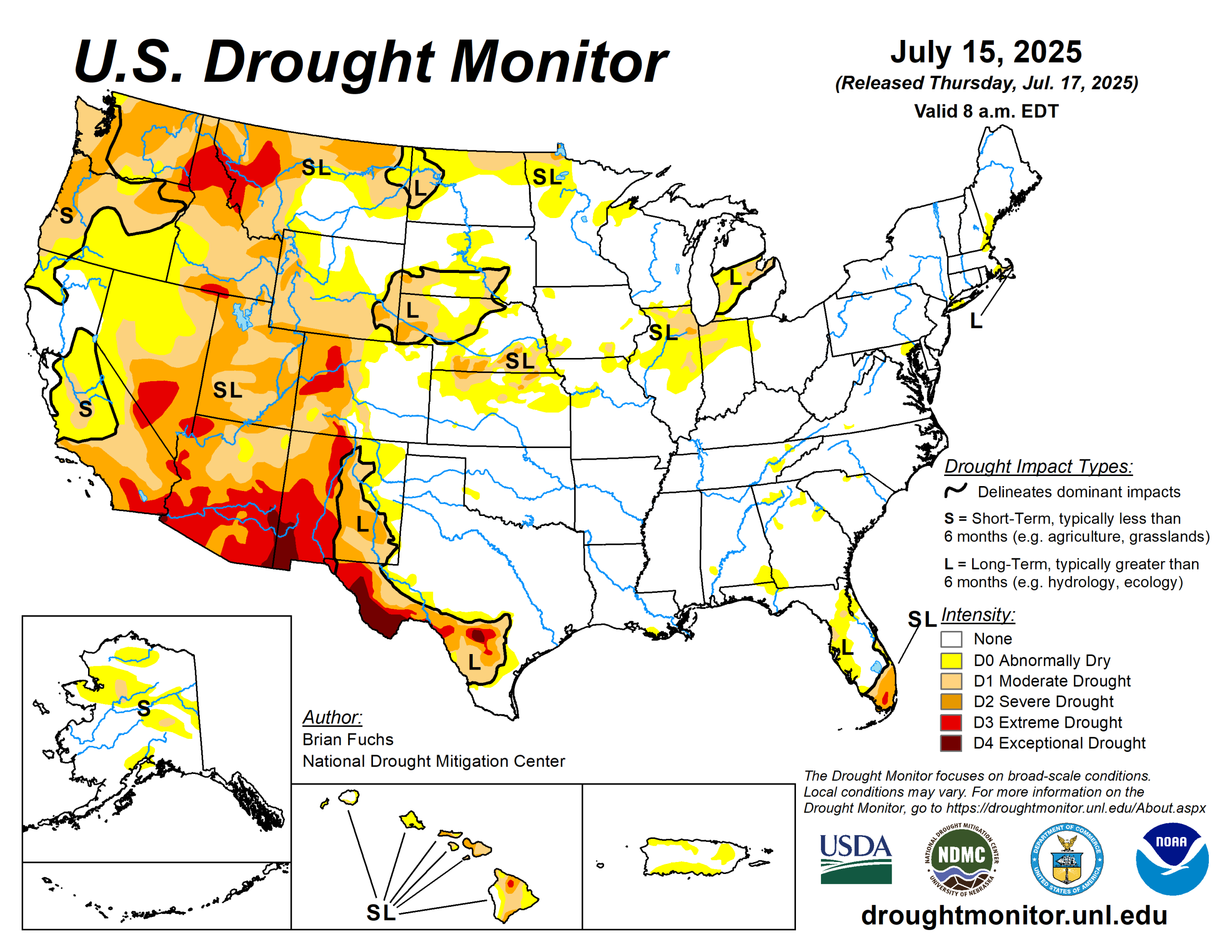
The U.S. Drought Monitor is jointly produced by the National Drought Mitigation Center at the University of Nebraska-Lincoln, the U.S. Department of Agriculture and the National Oceanic Atmospheric Administration. (Map courtesy of NDMC.)
South
The wettest areas of the region were over central and eastern Texas as well as into portions of eastern Oklahoma and western Arkansas.
Dry conditions were mostly over west and southern Texas and along the Oklahoma border in northern Texas. With the rain, temperatures were cooler than normal over much of Texas, with some areas of central Texas 3 to 5 degrees below normal for the week. Only eastern Arkansas and south Texas were at or above normal for the week.
Abnormally dry conditions were improved over southwest Arkansas while much of central Texas had the drought intensities reduced due to the ongoing rains. Some areas of Texas recorded enough rain where a multiple category improvement was made.
Midwest
The wettest areas of the region were from Iowa and into Illinois and Missouri where greater than 200% of normal rain fell. The driest areas included portions of western Missouri, where less than 10% of normal rainfall occurred.
Temperatures were at or above normal over most all the region with the eastern extent being the warmest with departures of 2 to 4 degrees above normal, while parts of western Iowa and southern Missouri were 2 to 4 degrees below normal. The areas that received the best rains also had improvements. In northern Illinois, abnormally dry to severe drought conditions were improved, while abnormally dry and moderate drought over much of eastern Iowa and portions of northwest Iowa also improved.
In Minnesota, abnormally dry conditions were improved over the southwest and northern portion of the state with some improvements to moderate and severe drought in the far north. Abnormal dryness and moderate drought improved over northeast Missouri this week.
High Plains
Temperatures were mixed over the region with the northern and western areas 2 to 4 degrees above normal while the southern and eastern areas were 2 to 4 degrees below normal for the week. The wettest areas were in southwest Kansas, northeast Nebraska and portions of northeast Colorado, where over 200% of normal rain was recorded.
Dryness continued in eastern Wyoming and in areas of the Dakotas as well as in northeastern Kansas. The wetter pattern over Nebraska over the past several weeks has allowed continued improvement to drought in the state. A full category improvement was made over most of central and northeast Nebraska and into portions of southern South Dakota.
Moderate drought and abnormally dry conditions were improved over northeast Colorado while abnormally dry conditions expanded over northeast Kansas.
West
Temperatures for the week were warmer than normal over the region with departures of 4 to 6 degrees above normal. The only areas that were at or below normal were coastal areas of California and eastern New Mexico. Much of the area remained dry and there was only some spotty monsoonal moisture over the Southwest. Some areas of Montana did receive some needed rain, but conditions have been dry overall in that region.
Degradation dominated the region for changes this week with no areas seeing improvements on the map. Severe and extreme drought were expanded over western Colorado while moderate drought and abnormally dry conditions were expanded over much of central Wyoming.
Severe and extreme drought expanded over western portions of Montana.
Looking ahead
Over the next five to seven days, it is anticipated that the Southern Plains and the West will be dry with only a burst in monsoonal moisture over the Four Corners region.
The greatest amount of precipitation is projected over the Midwest and into the Mid-Atlantic as well as the central and northern Plains. A tropical disturbance forming over the Gulf is likely to come ashore in and around Louisiana, bringing significant moisture to the coastal and inland areas.
Temperatures are anticipated to be below normal over the coastal areas of the West and into the northern Rocky Mountains with departures of 3 to 5 degrees. Temperatures will be warmest over the central Plains and into the Midwest with anticipated departures of 6 to 8 degrees above normal.
The 6-to 10-day outlooks show the greatest likelihood of above-normal temperatures is over the Midwest and into the Ozark Plateau. Outside of the coastal areas of the West, most of the rest of the country is projected to have the best chances of above-normal temperatures.
The greatest chances of below-normal precipitation is over the Great Basin as well as in the Southern Plains.
Brian Fuchs is with the National Drought Mitigation Center.


