Eastern High Plains received welcome rain
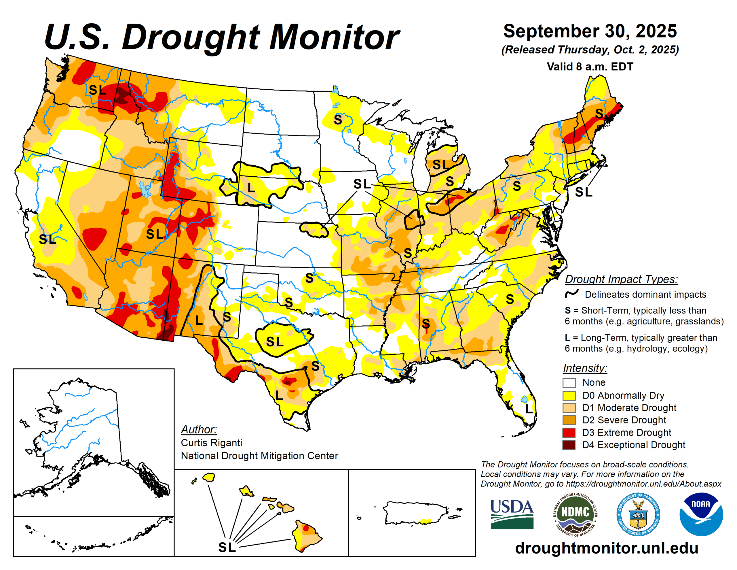
Widespread rains fell from parts of southern Missouri and Arkansas northeastward into the northeast United States. Amounts of 1 to 2 inches were common, and locally higher amounts fell, especially in northwest and southern Arkansas.
Areas that received these rains were experiencing drought or abnormal dryness. For some, the rain provided enough relief to improve conditions, while for others, especially in south-central Missouri and northern Arkansas and in New England, heavier rains were only enough to halt recent worsening trends.
Very dry weather continued in northern parts of Illinois, Indiana, Ohio, most of Lower Michigan and the northern Great Plains and Upper Midwest, leading to some deterioration in areas that have remained dry recently. Recent precipitation in parts of the High Plains and West led to improvements for the northern Colorado Front Range into the southeast half of Wyoming, and in portions of New Mexico. Continual dry weather led to worsening conditions in northern Montana and adjacent western North Dakota, where abnormal dryness and moderate and severe drought expanded in coverage.
The U.S. Drought Monitor is jointly produced by the National Drought Mitigation Center at the University of Nebraska-Lincoln, the U.S. Department of Agriculture and the National Oceanic Atmospheric Administration. (Map courtesy of NDMC.)
South
The South was warmer than normal for late September, with temperature anomalies mostly checking in 2 to 6 degrees Fahrenheit above normal. Rainfall amounts across the region varied widely. Southern and northwest Arkansas were quite wet, with widespread rain amounts from 2 to 4 inches, with locally higher amounts.
More isolated 1- to 2-inch rain amounts fell in central Texas and southeast Oklahoma. The central Texas rains were sufficient for a few local improvements, though one area that remained drier saw a local expansion of moderate drought. Farther southeast in Texas, mostly drier weather led to widespread expansion in severe drought in the Austin area, along with expanding moderate drought and abnormal dryness nearby and to the east.
Recent drier and warmer weather led to some local expansion of abnormal dryness and short-term moderate drought in central Oklahoma.
The heavier rains in parts Arkansas increased soil moisture and streamflow and lessened precipitation deficits in the areas of heaviest rainfall. This led to widespread 1-category improvements and a 2-category improvement in southwest Arkansas. Despite the rainfall in northern Arkansas, short-term precipitation deficits remained significant enough that improvements in this area were mostly limited this week.
Midwest
Well-above-normal temperatures covered the Midwest region during the last week of September, with temperatures of 6 to 10 degrees above normal in Iowa. Heavy rain amounts of 1 to 3 inches, with locally higher amounts, fell in far southern portions of Missouri and parts of west-central Missouri.
The heavy rainfall in the aforementioned areas was sufficient for 1-category improvements where short-term precipitation shortfalls lessened and soil moisture and streamflow increased.
Mostly dry weather occurred in northeast Missouri and the northern half of Iowa and Minnesota. Decreases in soil moisture and streamflow and growing short-term rainfall deficits led to 1-category degradations in parts of northern Minnesota. Widespread poor forage production was reported recently across southern Missouri.
High Plains
Mostly warmer-than-normal temperatures occurred across the High Plains this week, except for central and southern parts of Colorado.
The Dakotas and northern Wyoming were especially warm as September reached its end, with temperatures mostly 6 to 10 degrees above normal. Widespread moderate to heavy precipitation fell from southwest Nebraska and northwest Kansas into northern Colorado and southeast Wyoming, including some wintry precipitation at higher elevations. Rainfall amounts locally exceeded 2 inches in parts of northeast Colorado and adjacent parts of Nebraska and Kansas.
In northern Colorado and southeast Wyoming, recent precipitation improved soil moisture and streamflow and reduced precipitation shortfalls, leading to widespread 1-category improvements in these areas. In south-central South Dakota, recent wetter weather led to the removal of moderate drought, as conditions were re-evaluated this week in that area. Moderate drought expanded slightly in the San Luis Valley of south-central Colorado, where short-term precipitation deficits mounted amid poor vegetation conditions.
West
In the West, temperatures were mostly warmer than normal, with the exception of parts of New Mexico. Isolated rains of 2 or more inches fell in parts of west-central New Mexico, leading to localized 1-category improvements there.
Recent dry weather and dropping soil moisture, streamflow and groundwater levels led to expansions of severe and moderate drought and abnormal dryness across northern Montana.
Looking ahead
Between the evening of Oct. 1 to Oct. 6, the National Weather Service Weather Prediction Center is forecasting mostly dry weather across large portions of the contiguous U.S., spanning from southern California east and northeast through the Ohio Valley, eastern Great Lakes and Northeast.
Precipitation amounts of at least 0.75 inches are confined to parts of northern Wyoming, southern Montana, western South Dakota and central North Dakota.
Looking ahead to Oct. 7 to 11, forecasts from the National Weather Service Climate Prediction Center strongly favor above-normal precipitation in the Southwest, especially New Mexico, while above-normal precipitation is moderately favored in parts of the central Great Plains. The CPC forecast slightly favors below-normal precipitation in parts of the south-central U.S. Most of the southwest, central and eastern U.S. are favored to see above-normal temperatures.
Portions of the West spanning California into central and eastern Montana may see near-normal temperatures.
Curtis Riganti is with the National Drought Mitigation Center.