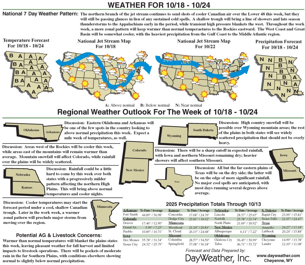
Heavy rains hit Four Corner states
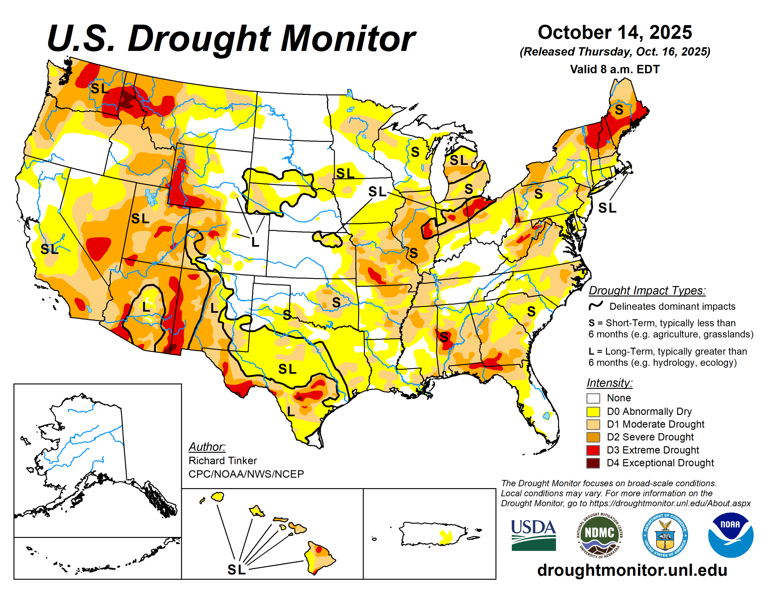
A late-season surge of tropical moisture brought heavy precipitation and areas of flooding to parts of the Four Corners states. Amounts of 4 to locally over 6 inches were reported in parts of interior Arizona and southern Colorado.
Farther east, a potent coastal storm system brought gusty winds and heavy rains to parts of the East Coast. Rainfall totals approached one foot near Georgetown and Pawley’s Island, South Carolina, while amounts of 7 to 10 inches were scattered across South Carolina and near Whiteville, North Carolina.
Totals of 4 to 6 inches were measured at scattered locations from South Florida northward through eastern Massachusetts. Wind gusts reached 60 to 65 mph at several buoys near the North Carolina Coast; Cape Lookout, North Carolina; and Island Beach Park, New Jersey.
In contrast, only a few tenths of an inch, at most, fell across southeast California, most of the Great Basin, the central and northern High Plains, much of the Great Plains, the Great Lakes region, portions of the Middle and Lower Mississippi Valley, much of the interior Deep South, and the Gulf Coast region.
Drought designations improved by multiple categories in some of the wetter areas across interior Arizona, southern Colorado, and eastern South Carolina while broad areas of 1-category improvement covered the central and southwestern Four Corners region. The Middle and Lower Ohio Valley and adjacent locations, and portions of the Atlantic Coast from south Florida through southern New England. In contrast, dryness and drought persisted or intensified across large parts of the Deep South away from the Atlantic Coast, the central Gulf Coast Region, the Lower Mississippi Valley, the east-central and south-central Great Plains, and scattered locations across the northern tier of the Lower-48 from Montana through northern New England.
The U.S. Drought Monitor is jointly produced by the National Drought Mitigation Center at the University of Nebraska-Lincoln, the U.S. Department of Agriculture and the National Oceanic Atmospheric Administration. (Map courtesy of NDMC.)
South
Recent rainfall allowed for some improvement in dryness and drought across central Oklahoma and western Texas. However, deterioration was more common in aggregate across the South Region, with most of northwestern Mississippi, Louisiana, and eastern Oklahoma noting some intensification.
There were scattered areas of moderate to locally heavy rainfall, but most of the region recorded subnormal amounts for the week.
Midwest
Lesser amounts of rain led to scattered areas of deterioration across Minnesota, northwestern Iowa and parts of Missouri (especially the western tier).
For the past two months, precipitation totals 4 to 8 inches below normal are fairly widespread across most of Missouri plus parts of southwestern Iowa.
High Plains
Heavy to excessive precipitation pounded the higher elevations of Colorado.
Most areas from west-central through south-central portions of the state received at least 3 inches of precipitation, with much heavier amounts— approaching 8 inches in spots—falling on the higher elevations of south-central Colorado. This precipitation let to widespread improvements, with some of the wetter areas noting 2-category improvements.
Elsewhere light to moderate precipitation (generally 0.5 to 1.5 inches) fell on most of the Plains and Wyoming, with amounts over an inch recorded in isolated sections of central Kansas, eastern North Dakota, and westernmost Wyoming.
Significant areas of dryness development or deterioration were limited to eastern Kansas and the southern tier of South Dakota.
West
Late-season tropical moisture surged into the Four Corners, bringing heavy to excessive precipitation to large parts western New Mexico. Improvement was also noted in scattered areas across southwestern Montana.
The only areas of deterioration were in north-central and northeastern Montana, where parts of a few counties slid from D0 into moderate drought. In other parts of the West region, precipitation amounts were nondescript, and dryness and drought were essentially unchanged.
Looking ahead
During Oct. 15 to 20, heavy precipitation (1.5 to 3 inches) is forecast for eastern Montana and adjacent North Dakota. Moderate amounts of 0.7 to 1.5 inches are anticipated in the northern Intermountain West, central and northern Wyoming, the northern tier of the Plains, parts of the central Great Plains.
Meanwhile, a few tenths of an inch at most are expected across the southern half of the Plains, and the southwestern quarter of the Lower-48. Temperatures should average generally below-normal from the Rockies westward, and above-normal from the Plains to the Atlantic Coast. Readings may top out 8 to 11 degrees Fahrenheit above normal on average across central and southern Texas.
The Climate Prediction Center’s 6- to 10-day outlook valid for Oct. 21 to 25 indicates better than normal conditions are nominally favored across southern sections of the Rockies and High Plains and central and western Texas. Subnormal precipitation is more likely across central and northern sections of the Rockies and Great Plains.
Southern Texas is most likely to experience warmer than normal weather. Temperatures are expected to average closer to normal for the Rockies.
Richard Tinker is with National Oceanic Atmospheric Administration, National Weather Service, National Centers for Environmental Prediction, and Climate Prediction Center.