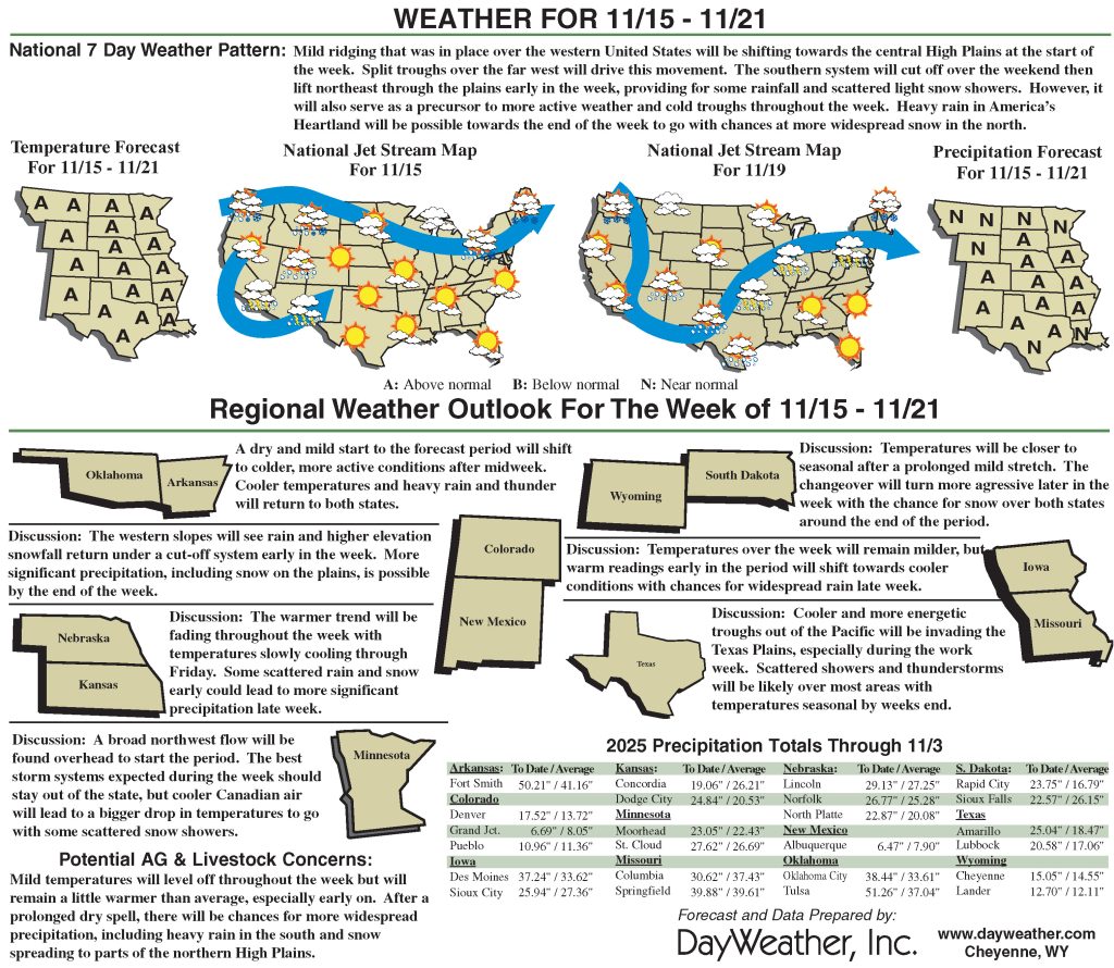
Warm and dry weather story for most of the High Plains
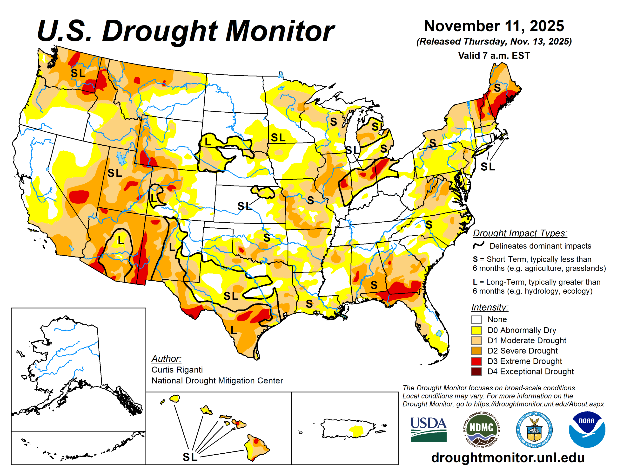
Mostly dry weather occurred this week across the Great Plains, Minnesota and Wisconsin, the south-central United States and the Southwest. Northwest Montana received moderate to heavy precipitation amounts.
Drier weather in parts of the Great Plains and south-central U.S. led to widespread degradations, especially in Texas and Oklahoma. Montana was split with improvement in the west and degradation in north-central areas, which continued a recent dry spell.
The U.S. Drought Monitor is jointly produced by the National Drought Mitigation Center at the University of Nebraska-Lincoln, the U.S. Department of Agriculture and the National Oceanic Atmospheric Administration. (Map courtesy of NDMC.)
South
Warmer-than-normal temperatures occurred across most of the week. Temperatures in Texas and Oklahoma were especially warm, with many areas in these states finishing the week 4 to 8 degrees Fahrenheit above normal. Parts of southwest Texas were even warmer, with some sites finishing the week more than 10 degrees above normal.
Degradations to abnormal dryness and drought were widespread from the southern half of Oklahoma to southwest Arkansas, and from central and eastern Texas into parts of Louisiana. Short-term drought impacts were the big story in southern Oklahoma, where short-term precipitation deficits grew and soil moisture and pond levels dropped and vegetation struggled.
Streamflow levels struggled in portions of central and southern Texas, while soil moisture levels also dropped in south Texas amid unusually high evaporative demand for the time of year.
Midwest
Temperatures were 2 to 6 degrees above normal in southern Missouri. Temperatures were variable across the rest of the region, though most areas were within 4 degrees of normal.
Moderate drought expanded in a few spots in southeast Missouri, where recent dry weather added to short-term precipitation deficits amid poor soil moisture and streamflow levels.
High Plains
Temperatures in the eastern edge of the High Plains area remained mostly within a couple degrees of normal, as a strong cold front moved into the central U.S. near the end of the period. Otherwise, most of the region was warmer than normal, especially western Nebraska and central and western portions of Colorado and Wyoming, where temperatures from 4 to 8 degrees above normal were common.
Some precipitation, generally under a half inch liquid equivalent, fell from central South Dakota to northeast Nebraska. Precipitation exceeding a half inch also fell in northwest Wyoming in the vicinity of Yellowstone National Park and in a section of the Black Hills of South Dakota. Elsewhere, mostly dry weather was the rule across the region.
Short-term precipitation deficits grew in parts of eastern Nebraska, where abnormal dryness expanded in coverage north and northwest of Lincoln. Portions of western Nebraska and adjacent southeast Wyoming and Colorado continued to dry as well, and abnormal dryness and some moderate drought grew in these areas. In south-central Colorado, localized degradations were also due in part to effects from longer-term precipitation deficits.
West
Temperatures were above normal across the region. Southern New Mexico were generally the warmest compared to normal, with many spots in these areas finishing the week 6 to 10 degrees above normal. Many parts of northwest Montana and northern Idaho received half an inch to 2 inches of precipitation.
Drought conditions lessened across much of western Montana as a result of recent precipitation events. In north-central Montana, drought conditions worsened as weather stayed mostly dry, leading to larger short-term precipitation deficits and low streamflow levels.
Looking ahead
From the evening of Nov. 12 through Nov. 17, the National Weather Service’s Weather Prediction Center is forecasting heavy precipitation to fall across parts of the western U.S. Precipitation amounts from 3 to 5 inches (locally higher) may fall across large portions of California, especially the southwest coastal areas and portions of the Sierra Nevada.
Heavy precipitation amounts from 2-5 inches (locally higher) are also anticipated in parts of northwest Washington and the Olympic Peninsula. Over 0.75 inches of precipitation is also forecast in southeast California, southern Nevada, portions of western and central Arizona and southwest Utah.
A few other locales may receive an inch or more of precipitation, including the San Juan Mountains in southwest Colorado and parts of the northern Idaho Panhandle and northwest Montana. Much drier weather is forecast across most of the rest of the contiguous U.S. for this period, though some parts of New York and New England may receive over a half inch of precipitation.
For the period from Nov. 18 to 22, the NWS Climate Prediction Center forecast favors above-normal precipitation across much of the contiguous U.S., especially from the Southwest northeastward to the Lower Ohio River Valley.
Warmer-than-normal temperatures are favored to the east of the continental divide. Forecaster confidence in warmer-than-normal weather is highest from the Gulf Coast north to the Lower Midwest and southern Great Plains, and near and west of Lake Superior.
Curtis Riganti is with the National Drought Mitigation Center.