Mother Nature being stingy with moisture
The past week featured above-normal temperatures across much of the western half of the United States.
Areas west of the Mississippi River generally experienced near- to above-normal temperatures, with portions of the northern Rocky Mountains running 15 to 20 degrees Fahrenheit above normal for the week. These warm conditions favored rain over snow, which is critical for winter water supply in the West, and many locations continue to experience a slow start to the snow season.
In contrast, cooler-than-normal temperatures dominated the Florida Peninsula, with departures of 5 to 10 degrees below normal across southern Florida. Below-normal temperatures were also widespread from the Upper Midwest into the Northeast and Mid-Atlantic, where departures of 5 degrees or more below normal were common. Parts of New England were particularly cold, with temperatures 10 to 15 degrees below normal.
Outside of the West, above-normal precipitation was limited to pockets of the Southeast, Florida, and the Upper Midwest. Much of the West recorded more than 100% of normal precipitation for the week, with large portions of California receiving over 200% of normal.
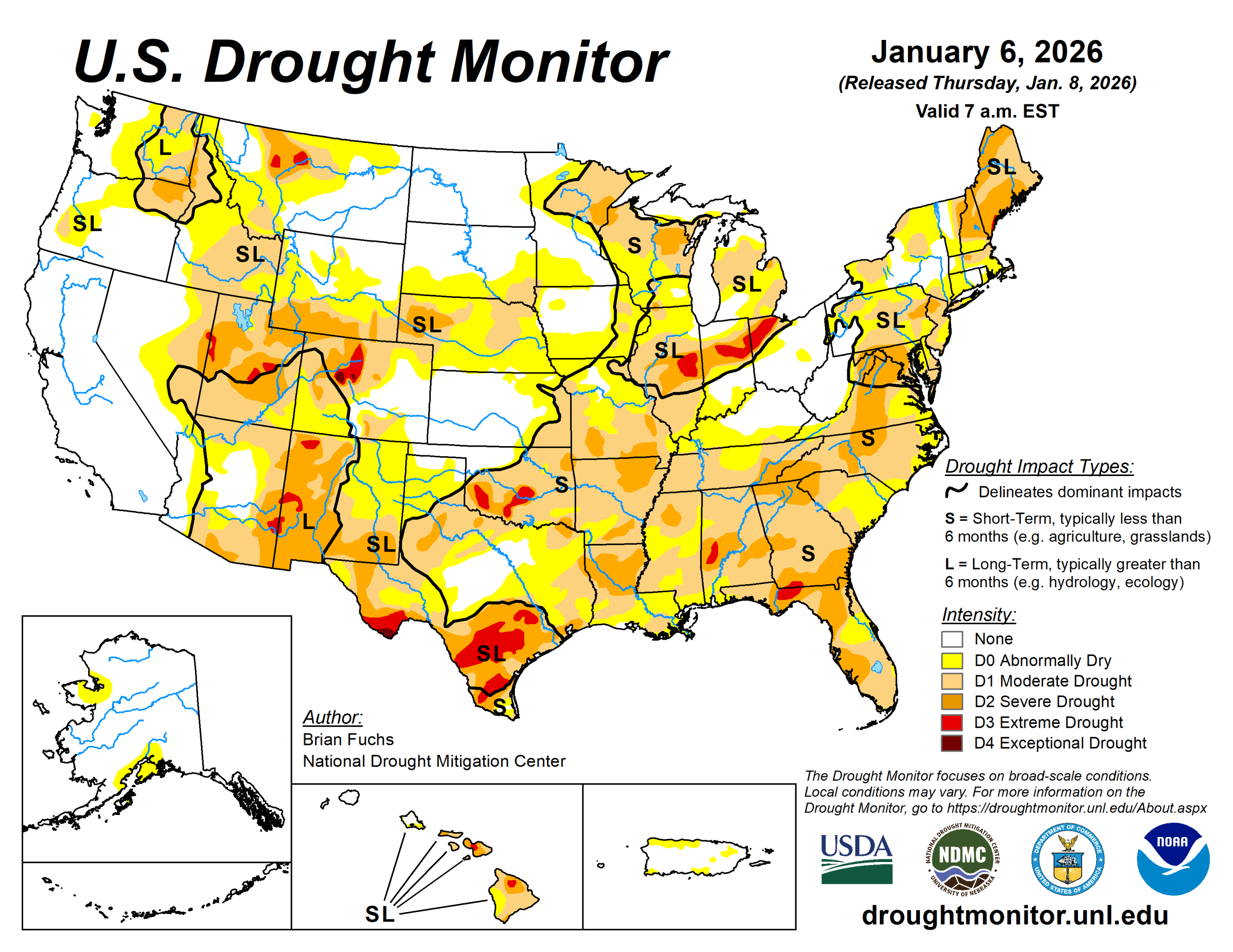
The U.S. Drought Monitor is jointly produced by the National Drought Mitigation Center at the University of Nebraska-Lincoln, the U.S. Department of Agriculture and the National Oceanic Atmospheric Administration. (Map courtesy of NDMC.)
South
Nearly the entire region was dry. Temperatures were above normal across most areas, with portions of the Texas and Oklahoma panhandles running more than 12 degrees above normal.
Drought conditions deteriorated across every state in the region. Moderate and severe drought expanded across much of southern and western Arkansas. Severe drought expanded in northeast and northwest Arkansas and into northeast Oklahoma. Severe and extreme drought spread from southwest into central Oklahoma, while moderate drought continued to fill in across eastern Oklahoma.
Across Texas, moderate drought and abnormally dry conditions expanded over much of the Panhandle, while moderate and severe drought grew across east Texas and coastal southeast Texas. Drought conditions continued to intensify in far south Texas.
Midwest
Temperatures were cooler than normal across northern areas and near to above normal farther south. Western Iowa and southwest Minnesota experienced temperatures 9 to 12 degrees above normal. Most of the region was dry, though above-normal precipitation occurred in northern and eastern Minnesota.
Moderate drought and abnormally dry conditions improved over eastern Iowa. Moderate and severe drought also expanded across much of southern Missouri, while abnormally dry conditions increased over northwest Missouri and into southwest Iowa. Portions of east-central Minnesota saw improvement due to a wet start to January.
High Plains
Warmer-than-normal temperatures dominated the region, with departures exceeding 15 degrees above normal across parts of western Nebraska, western Kansas, northeast Colorado, Wyoming, and southeast Montana. Precipitation was minimal, with the greatest totals confined to northeastern North Dakota.
The continued warm and dry winter has resulted in some areas experiencing their driest start to winter on record.
Abnormally dry conditions expanded across southern Nebraska and northeast Kansas, as well as southeast Kansas, where moderate drought also increased. Moderate and severe drought expanded across southeast Wyoming, western Nebraska, northeast Colorado, and southeast Colorado.
West
The largest positive temperature departures occurred in the West, with areas from central Montana into western Wyoming and northwest Colorado experiencing temperatures more than 15 degrees above normal.
These warm conditions pushed snow to higher elevations and increased rainfall at lower elevations. While many areas received above-normal precipitation, snowpack remains critically low, and significant snow drought persists across numerous mountain ranges, including the Cascades, Oregon’s Blue Mountains, Idaho’s Bitterroot Range, and the central Rocky Mountains of Colorado.
Above-normal precipitation also occurred across Montana. Severe and extreme drought improved across northern Montana, with additional improvement to moderate drought in the southwest part of the state.
Abnormally dry conditions expanded across northeast New Mexico, while extreme and exceptional drought expanded across central Colorado. Extreme drought was removed from southwest Wyoming, and moderate drought improved across western Wyoming.
Looking ahead
Over the next five to seven days, the pattern over the continental U.S. appears to be active with many areas showing a strong probability of precipitation. Areas from the Central Plains into the Midwest and Great Lakes areas are anticipated to receive up to an inch of precipitation.
Farther south, areas from Louisiana northeast into Kentucky are expected to receive the greatest amount of precipitation with several inches expected. From the Pacific Northwest into the Rocky Mountains and Southwest, widespread precipitation is anticipated. Dry areas are expected to be over the northern Great Plains, California, central and southern Texas and from the Carolinas into the Florida peninsula. Temperatures are expected to remain warmer than normal over much of the country. Only the areas along the southern tier of the U.S. will be near to below normal. The warmest departures are expected over the central to Northern Plains, with some areas of Montana predicted to be 10 to 15 degrees above normal.
The 6- to 10-day outlooks show that the likelihood of above-normal temperatures is projected over almost the entire U.S., except the Southeast and south Texas. The greatest chances of above-normal temperatures are over the West Coast, as well as the Northern Plains and northern Rocky Mountains. The best chances of below-normal precipitation are over the western U.S. and into the Southern Plains. Above-normal chances of above-normal precipitation are anticipated over the central to northern Plains, Florida and along the coast of the Carolinas, as well as Alaska and Hawaii.
Brian Fuchs is with the National Drought Mitigation Center.