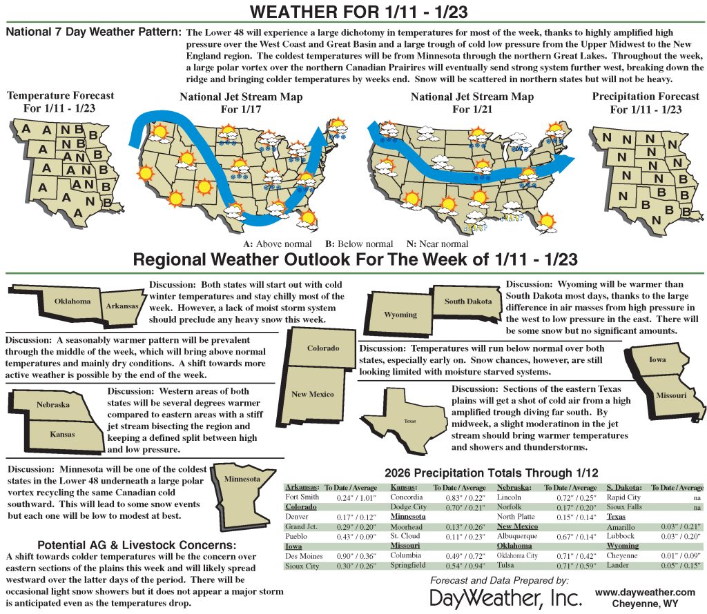
High Plains receives beneficial moisture
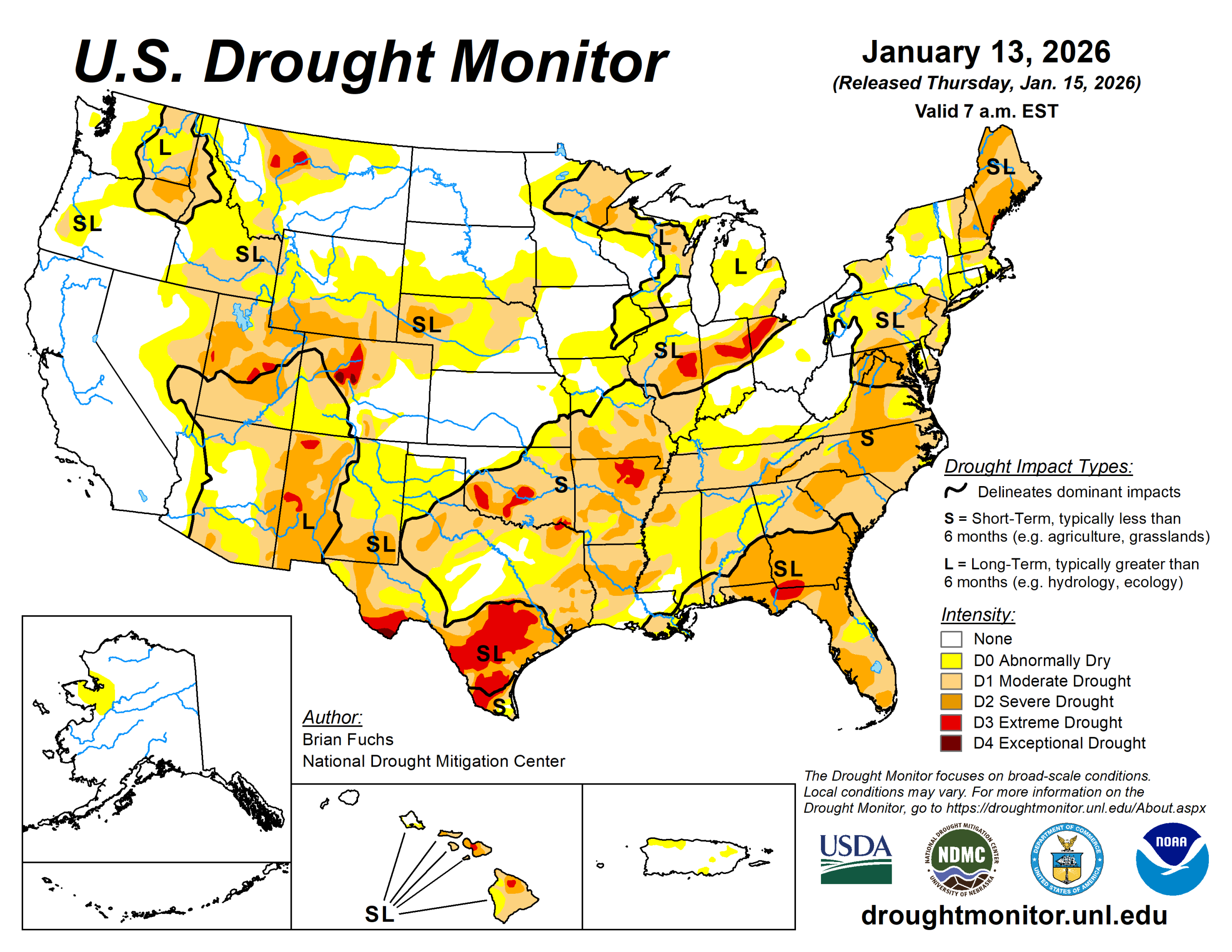
It was a more active week nationwide, with significant precipitation across the central Plains, Midwest and Southeast.
Parts of Mississippi and Alabama received more than 5 inches of rain. In the Plains and Midwest, much of the precipitation fell as rain rather than snow due to unseasonably warm temperatures. Portions of the Southwest and central Rocky Mountains also received beneficial rain and snow, slowing drought intensity and leading to localized improvements.
Temperatures were warmer than normal across most of the country, with near- to slightly below-normal temperatures limited to the West and Southwest. The largest departures occurred in the upper Midwest and Northern Plains, where temperatures were 15 to 20 degrees Fahrenheit above normal.
The U.S. Drought Monitor is jointly produced by the National Drought Mitigation Center at the University of Nebraska-Lincoln, the U.S. Department of Agriculture and the National Oceanic Atmospheric Administration. (Map courtesy of NDMC.)
South
Temperatures were above normal across nearly the entire region, with departures of 9 to 12 degrees above normal in the east and 6 to 9 degrees above normal across Texas and Oklahoma. Southeast Arkansas received well above-normal precipitation.
Central and southern Texas, eastern Oklahoma, and Arkansas remained largely dry. Drought expanded across much of Arkansas and eastern and southern Texas. Extreme drought expanded across south Texas, with a new area in northeast Texas. Moderate and severe drought also expanded across east Texas into Arkansas, while abnormally dry conditions increased in central Texas and western Oklahoma. Severe drought expanded from eastern Arkansas into western Tennessee.
Midwest
Temperatures were well above normal throughout the region, ranging from 12 to 16 degrees above normal in most areas and 8 to 12 degrees above normal in the east. Above-normal precipitation fell across much of Iowa, southern Minnesota and Missouri.
Much of the precipitation fell as rain, which was unusual for January, and with soils largely unfrozen, infiltration was efficient. Moderate and severe drought improved in central Illinois, while moderate drought and abnormally dry conditions improved in northern Missouri and southern Iowa. Moderate drought was also removed from eastern Iowa.
Southern Missouri remained dry, with moderate and severe drought expanding.
High Plains
Above-normal precipitation occurred across eastern Colorado, Kansas and southeast Nebraska, falling primarily as rain and infiltrating soils due to warm temperatures.
Much of the rest of the region remained dry. Temperatures were 10 to 15 degrees above normal across most areas, with parts of the Dakotas and eastern Montana 15 to 20 degrees above normal. Southeast Colorado was the only area near to below normal. Abnormally dry and moderate drought conditions improved in southeast Nebraska, eastern Kansas, and parts of south-central Colorado.
Drought expanded across eastern Wyoming, west-central South Dakota and northeast Colorado.
West
Above-normal precipitation occurred across western and central New Mexico and parts of Colorado. Temperatures were mixed, with New Mexico up to 5 degrees below normal, while northern areas were 5 to 10 degrees above normal and parts of central Montana were 15 to 20 degrees above normal.
Most drought changes reflected improvement, including moderate drought and abnormally dry conditions in western Montana and central Idaho, severe drought in western Colorado, and severe to extreme drought in western New Mexico. However, drought expanded to extreme and exceptional drought expanded in central Colorado, and abnormally dry and moderate drought conditions expanded across much of eastern Wyoming.
Looking ahead
Over the next five to seven days, much of the western half of the U.S. is anticipated to be dry from the West into the Plains. At the end of the period, there could be some coastal precipitation in portions of south and east Texas.
Temperatures during this time are anticipated to well above normal over the West, with departures of 10 to 13 degrees in Wyoming. Cooler-than-normal temperatures will be commonplace over the eastern half of the country, with the greatest departures over the upper Midwest and Great Lakes with departures of 10 to 13 degrees.
The 6- to 10-day outlooks show that the likelihood of above-normal temperatures over much of the Southwest and southern Plains. The best chances of below-normal temperatures will be over the upper Midwest and into the Northeast. The best chances of above-normal precipitation are anticipated over the Rocky Mountains and into the Southwest.
Brian Fuchs is with the National Drought Mitigation Center.