Moisture helps ease drought in past week
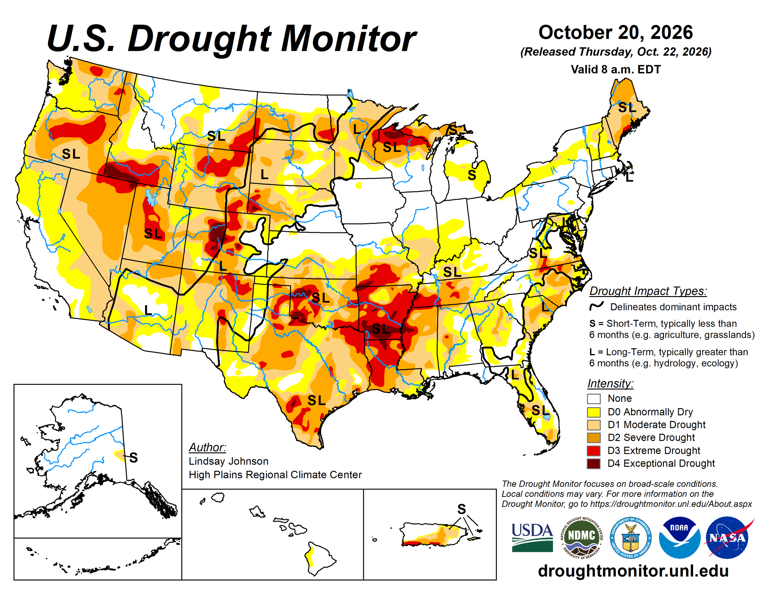
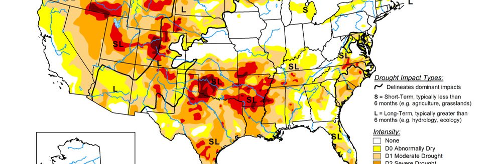
Drought conditions improved across large areas of the United States this past week, while deterioration extended from the Lower Mississippi Valley into the western Ohio River Valley.
Temperatures averaged 2 to 6 degrees Fahrenheit above normal across much of the Northern Plains, Midwest, Northeast, and West, with localized departures of 6 to 9 degrees. Near- to below-normal temperatures prevailed across portions of the Southern Plains, Southwest and Southeast.
Precipitation varied considerably, with much of the Pacific Coast, Northern Plains and Southeast receiving less than 25% of normal rainfall, while portions of the central and Southern Plains, Rockies and Upper Midwest received more than 200% of normal, locally exceeding 400%.
A powerful storm system brought heavy to excessive rainfall across portions of Texas and Oklahoma Oct. 13 to 15, with totals of 3 to 5 inches in the southeastern Texas Panhandle and localized amounts of 6 to 8 inches in western and central Oklahoma. The storm caused localized flooding and a record crest along the Middle Wichita River in northwestern Texas.
Rainfall departures locally exceeded 6 inches above normal, providing substantial relief from prolonged dryness and supporting widespread drought improvements across Texas and Oklahoma. Additional improvements occurred across portions of Kansas, Nebraska, Colorado, Wyoming, Utah, Arizona, and New Mexico, where recent rain and mountain snow helped replenish soil moisture and ease short-term deficits. Localized improvements also occurred in Washington.
In contrast, drought intensified from the Lower Mississippi Valley into the western Ohio River Valley, particularly across Arkansas, Louisiana, Mississippi, Tennessee and southern Missouri, with localized degradations extending into Alabama, northern Georgia and the southern Midwest. Persistent 30- to 90-day precipitation deficits, depleted soil moisture and exceptionally low streamflows supported these changes. Keetch-Byram Drought Index values, which measure dryness in the upper soil and vegetation layers, reached 700 to 800 in portions of Arkansas, Louisiana and Mississippi, indicating severe dryness and elevated wildfire potential.
The U.S. Drought Monitor is jointly produced by the National Drought Mitigation Center at the University of Nebraska-Lincoln, the U.S. Department of Agriculture and the National Oceanic Atmospheric Administration. (Map courtesy of NDMC.)
South
Drought conditions varied considerably across the South, with substantial improvements across portions of Texas and Oklahoma contrasting with continued deterioration across the Lower Mississippi Valley and Tennessee.
A powerful storm system brought heavy to excessive rainfall to the Southern Plains Oct. 13 to 15, providing significant relief following prolonged hot and dry conditions during August and September. Rainfall totals of 3 to 5 inches were reported across portions of the southeastern Texas Panhandle and northern Rolling Plains, while localized totals reached 6 to 8 inches west of Oklahoma City (National Weather Service in Lubbock, Texas, and NWS Weather Prediction Center). Oklahoma City recorded 4.99 inches by late afternoon Oct. 14 (NWS-Norman), while Lubbock, Texas, received 2.04 inches during the storm period (NWS-Lubbock).
The heavy rainfall caused localized flooding and substantial rises in streams and rivers, including a record crest of 18.91 feet on the Middle Wichita River near Guthrie, Texas (NWS-Lubbock). Improving precipitation indicators, soil moisture and streamflows supported widespread one-category improvements across western and northern Texas, the Texas Panhandle and much of Oklahoma, including reductions in exceptional drought. However, accumulated moisture deficits limited more widespread drought removal.
In contrast, drought intensified across other portions of Texas, Arkansas, Louisiana, Mississippi and Tennessee, where rainfall remained insufficient to offset prolonged deficits. Keetch-Byram Drought Index values reached approximately 700 to 800 in parts of Arkansas, Louisiana and Mississippi, indicating severe dryness. Extreme drought expanded across northern Arkansas, while exceptional drought developed or expanded across southern Arkansas. Worsening 30-, 60- and 90-day precipitation indicators, severely depleted soil moisture and exceptionally low streamflows supported these changes.
Agricultural impact reports also documented worsening conditions across Arkansas.
Midwest
Drought conditions were mixed across the Midwest with localized improvements and degradations concentrated in the southern portion of the region. Precipitation was widespread but unevenly distributed, with much of Minnesota and Iowa receiving approximately 0.25 to 1.5 inches of rain and locally higher amounts of 1.5 to 2 inches. Farther south, rainfall generally ranged from 0.5 to 2 inches across portions of Missouri. Although the rainfall provided localized relief, accumulated precipitation deficits and lingering moisture shortages continued to affect portions of the region, particularly northern Minnesota.
One-category improvements occurred across portions of Missouri, where recent rainfall helped ease short-term moisture deficits and improve soil moisture conditions. However, localized degradations also occurred across Missouri in areas that missed the heavier rainfall or continued to experience substantial precipitation deficits. The most significant deterioration occurred across southern Missouri, where extreme drought expanded along the Arkansas border.
Across Minnesota and Iowa, drought conditions remained largely unchanged, as recent precipitation helped stabilize short-term conditions but was insufficient to overcome longer-term moisture deficits.
High Plains
Drought conditions generally improved across portions of the central and southern High Plains, while no changes occurred across the Northern Plains. Temperatures averaged 2 to 6 degrees above normal across much of the Dakotas and eastern Wyoming, with locally higher departures. Farther south, temperatures ranged from near to slightly above normal across portions of Nebraska, eastern Colorado and northern Kansas to 2 to 4 degrees below normal across southern Kansas.
Precipitation varied considerably, with much of North Dakota and northern South Dakota receiving less than 25% of normal rainfall. In contrast, portions of eastern Colorado, Nebraska and Kansas received more than 200% of normal precipitation, locally exceeding 400%. Rainfall totals of 1 to 2 inches were common across portions of the central High Plains, including 1 to 1.5 inches in central Nebraska and more than an inch in parts of the northern Nebraska Panhandle. Portions of eastern Wyoming received approximately 0.75 to 1.25 inches.
One-category improvements occurred across portions of eastern Wyoming, eastern Colorado, Nebraska and Kansas, where recent precipitation helped reduce short-term moisture deficits and improve soil moisture conditions. In Nebraska, improvements were concentrated across central, south-central and northeastern portions of the state, while additional improvements occurred across southern Kansas.
The only degradation in the region occurred in northeastern Colorado, where persistent moisture deficits supported a localized increase in drought severity. Longer-term deficits also continued to limit recovery across portions of eastern Wyoming, western Nebraska and western South Dakota.
No changes occurred across North Dakota and South Dakota, where precipitation during the current week was limited. However, moisture received during preceding weeks helped maintain existing drought conditions despite continued precipitation deficits and above-normal temperatures.
West
Drought conditions improved across portions of the West, with no deterioration reported. Temperatures averaged 2 to 6 degrees above normal across the Great Basin and the northern Rockies, with isolated areas reaching 6 to 8 degrees above normal. Farther south, temperatures were generally near to slightly below normal across portions of Arizona and New Mexico.
Precipitation was limited across much of Montana, where many areas received less than 25% of normal precipitation, including some areas receiving less than 5% of normal. In contrast, portions of western Colorado and Wyoming received more than 200% of normal precipitation, with localized amounts exceeding 400% of normal.
A storm system brought rain and high-elevation snow to portions of the Rockies on Oct. 14-15, with reported snowfall totals of 4.3 inches at Silver Lake Brighton, Utah, and 3 inches near Evanston, Wyoming, on Oct. 14 (NOAA snowfall).
Localized one-category improvements occurred in Washington, while no changes occurred across Oregon, California, Nevada, Idaho and Montana. Persistent streamflow shortages continued to affect portions of Idaho, while low surface water levels and long-term moisture deficits limited recovery in southeastern Montana. Farther south, one-category improvements occurred across portions of western and central Wyoming, the Colorado Rockies and New Mexico. In Wyoming and Colorado, recent rain and mountain snow helped ease short-term moisture deficits.
Repeated rainfall in recent weeks supported additional improvements across central and southern New Mexico. Despite these changes, long-term hydrologic drought persisted across portions of the Colorado River and Rio Grande basins. On Oct. 20, Lake Powell held approximately 5.3 million acre-feet of water, or about 22% of capacity, while reservoir storage along the Rio Grande remained exceptionally low (Bureau of Reclamation).
Looking ahead
Over the next five days (Oct. 22 to 27), the Weather Prediction Center’s quantitative precipitation forecast shows widespread precipitation across parts of the central and southern Rockies, particularly Colorado and northern New Mexico, where widespread totals of 1 to 3 inches are forecast, with localized amounts of 5 or more inches. Farther west, widespread precipitation is forecast across the Intermountain West and Pacific Coast, including Washington, Oregon and California, with totals generally ranging from 0.5 to 2 inches and locally higher amounts in mountainous areas. Across the Southwest, precipitation is expected across portions of Arizona, Utah and New Mexico, while southern California and the lower deserts will remain relatively dry.
East of the Rockies, 0.5 to 2 inches is expected across portions of the central and northern Plains, with heavy precipitation of up to 3 to 5 inches expected from western Texas and the Panhandle, eastern New Mexico, Oklahoma’s Panhandle and southwestern Kansas. Much of the Mississippi Valley, Midwest, Southeast and Northeast are expected to remain dry.
The Climate Prediction Center’s 6- to 10-day temperature outlook (Oct. 26 to 30) favors above-normal temperatures across much of the southern two-thirds of the Lower 48, including California, the Southwest, central and southern Plains, Mississippi Valley and Southeast.
The highest probabilities for above-normal temperatures are centered across portions of the Southwest, Southern Plains and lower Mississippi Valley, where continued warmth could increase evaporative demand and reinforce existing moisture deficits in the areas that miss significant rainfall.
In contrast, below-normal temperatures are favored along the Canadian border from the northern Rockies into the northern Plains and across portions of northern New England. Near-normal temperatures are strongly favored across Alaska and most of Hawaii.
The Climate Prediction Center’s 6- to 10-day precipitation outlook (Oct. 26 to 30) favors above-normal precipitation across a broad area extending from California and the Southwest through portions of New Mexico and western Texas.
Lindsay Johnson is with the National Drought Mitigation Center.