Christmas brought little moisture to the Plains
Little to no precipitation was observed across the Southwest and the Plains under an anomalous ridge, and much above-normal temperatures promoted degradations of drought depictions for portions of the Rockies and Great Plains.
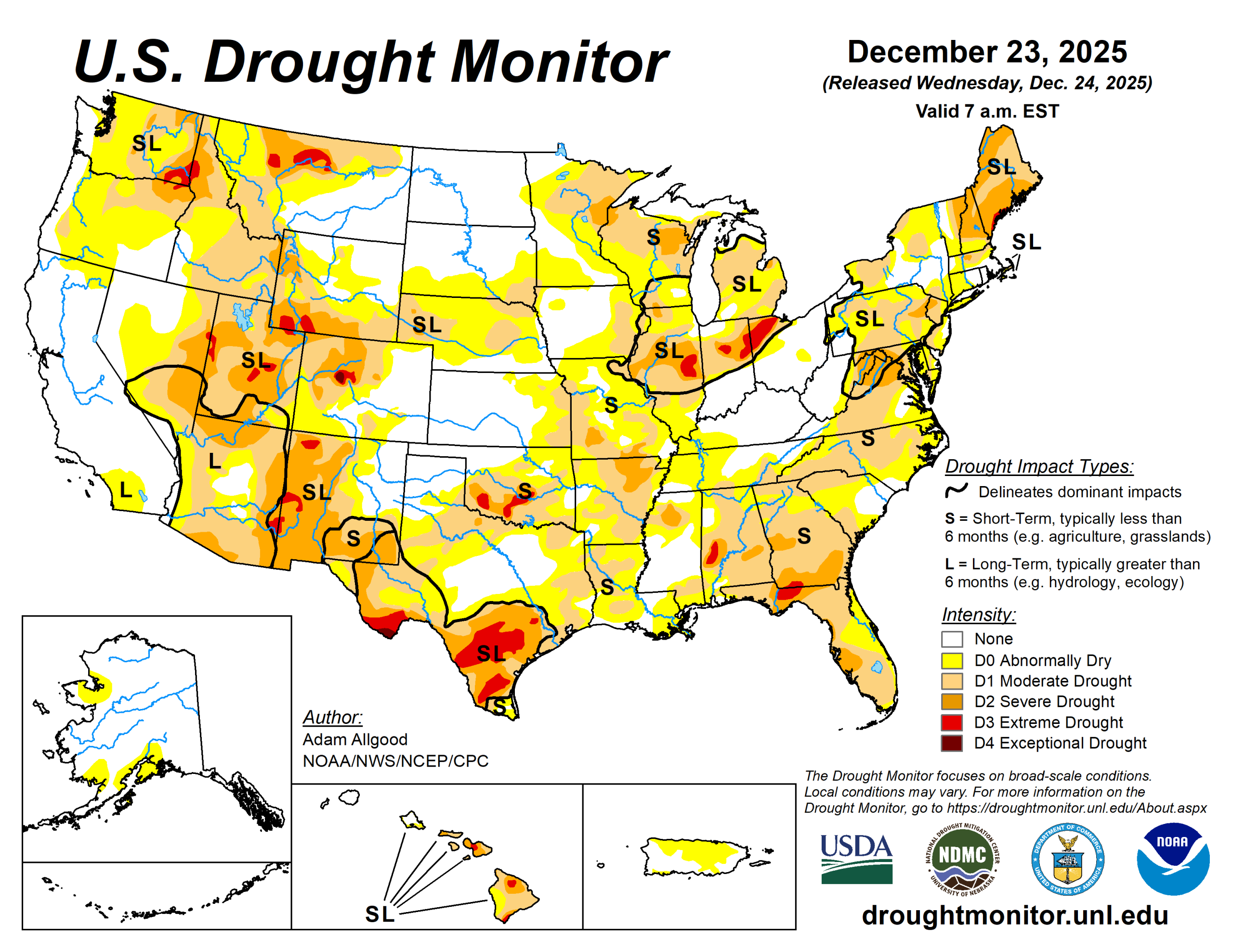
The U.S. Drought Monitor is jointly produced by the National Drought Mitigation Center at the University of Nebraska-Lincoln, the U.S. Department of Agriculture and the National Oceanic Atmospheric Administration. (Map courtesy of NDMC.)
South
Following another week of subnormal precipitation with temperatures ranging above-normal, the South experienced drought degradations.
A small area of heavier precipitation fell across far south Texas, resulting in reductions of D1 and D0, but drought expanded or intensified across the southern Texas plains, Hill Country, and the Piney Woods. Drought also intensified along the Red River Valley, and degradations were more widespread across the eastern two-thirds of Oklahoma and Arkansas.
In Arkansas, local observers continue to report drying lakes and ponds, while in Oklahoma, record warmth, strong winds, and persistently below-normal precipitation promoted expansion of D2 and D3 conditions.
Midwest
Mostly dry conditions were observed for the remainder of the upper Mississippi Valley, Iowa, and western Missouri. Light precipitation fell east of the Mississippi River, with accumulations increasing toward the east.
Overall, only small changes in the drought depiction were made across the region. A reassessment of impacts from prior precipitation led to reductions of D1 and D0 for northwestern Iowa, and a localized area of half-inch precipitation following snowfall in early December allowed some modest reductions of D1 across southeastern Iowa.
In contrast, drier conditions and above-normal temperatures led to some degradation across south-central Missouri.
High Plains
A lack of snow cover, much above-normal temperatures, and periods of strong winds led to an unusual amount of winter degradation across the High Plains region.
D2 expanded across western Nebraska, with expansions of both D1 and D0 occurring across central and eastern parts of the state, where precipitation was generally less than 0.2 inch equivalent, and high temperatures soared as high as the 70s. A small area of D1 expanded across southeastern Kansas, and across Colorado, D4 was introduced to Eagle and Pitkin Counties. D0 expanded across the plains of Wyoming, where warm temperatures, strong winds, and a record lack of snow cover promoted worsening impacts.
Drought depictions remained unchanged across the Dakotas, where soils and streams have largely frozen for the winter.
West
Based on these considerations, D1 and D0 were reduced along the western front of the Cascades and across small portions of the Intermountain West, but drought conditions were maintained across the higher elevations.
A small area of D0 reduction was made across northern Montana, where recent storminess brought improvements to 30- and 60-day SPI values.
Looking ahead
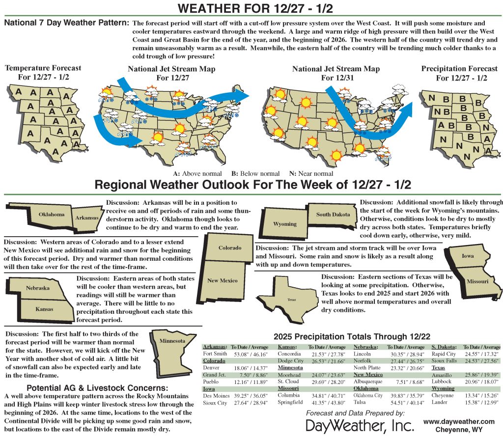
Heavy precipitation is forecast to push inland to the Great Basin and portions of the Rockies.
The WPC 7-day QPF forecast shows precipitation amounts exceeding an inch across most of the Northeast Region, much of which may fall as snow or a wintry mix across the mid-Atlantic. Mostly dry conditions are favored for the Southeast during Week-1, with light rain possible across the lower Mississippi Valley.
During Week-2, CPC forecast indicate enhanced chances for above-normal precipitation for the western third of the continental United States, with the highest probabilities across the Southwest.
Adam Allgood is with National Oceanic Atmospheric Administration, National Weather Service, National Centers for Environmental Prediction, and Climate Prediction Center.
Related Articles