Spotty rain provided relief in several High Plains states
Heavy precipitation (more than 3 inches) was observed this past week over many of the higher elevations and coastal areas from northern California to the Canadian Border. Farther east, similar amounts doused numerous locations from Oklahoma southward to central Texas.
Between 5 and 10 inches of precipitation fell in north-central through east-central Oklahoma and northeastern Texas. Moderate to heavy precipitation (between 1 and 3 inches with isolated higher amounts) was reported across the rest of the Pacific Northwest and parts of the higher elevations in the northern Intermountain West. Also moderate precipitatin fell in part of the northern Great Plains, in the central Great Plains and much of northern and central Texas.
This resulted in significant areas of improvement in the Pacific Northwest, northern Intermountain West, the Great Plains from eastern Kansas through central Texas, and the interior of the Deep South. In some of the drier areas, dryness and drought conditions deteriorated in a few parts of the central and northern High Plains, the Texas Panhandle, and coastal Texas.
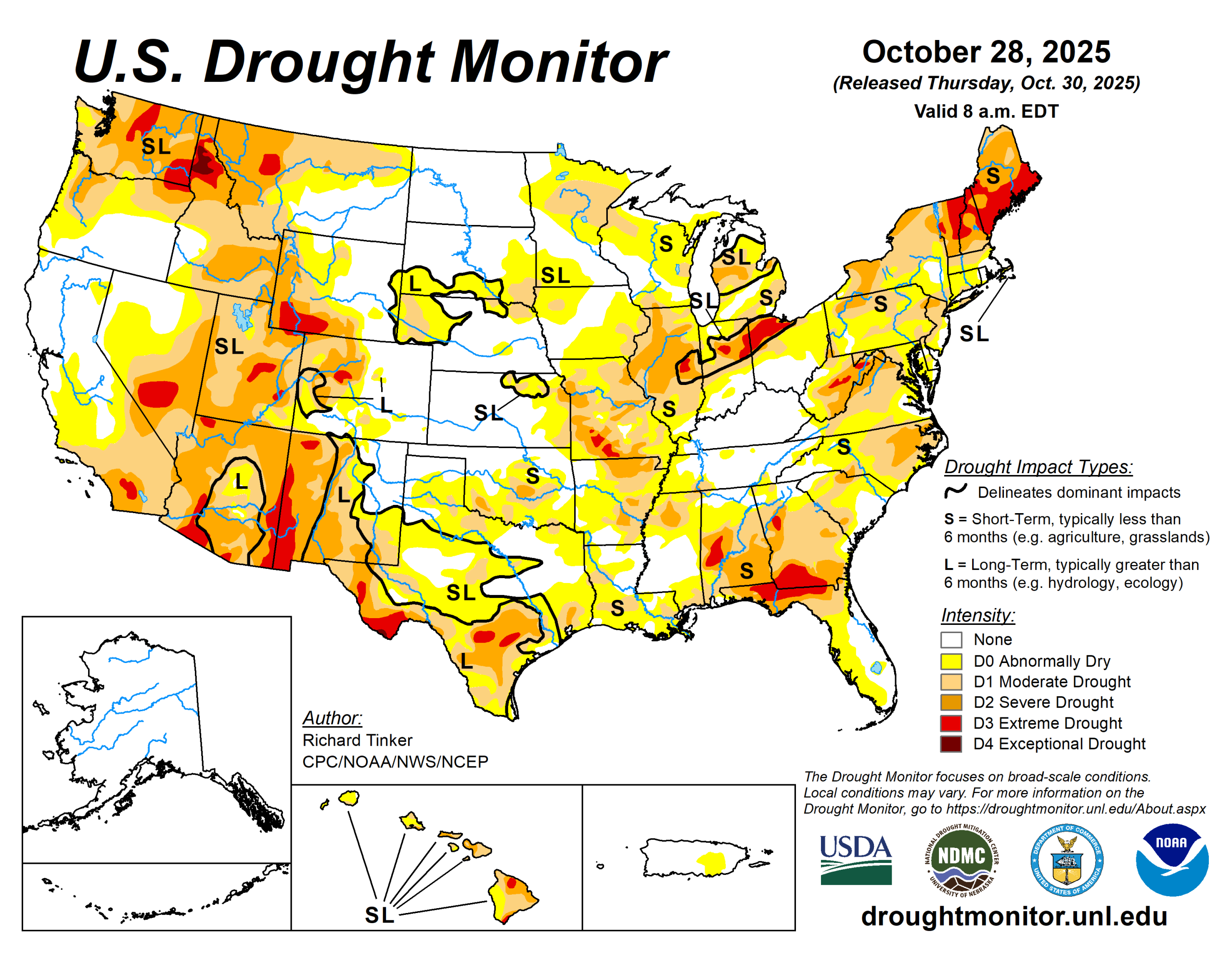
Overall, coverage of D0 or drier conditions across the Lower 48 declined slightly from 72 to 69%, remaining well above the average coverage since 2000 (49.2%). Drought (D1 or worse) extent also declined slightly from 46.1 to 43.6% of the Lower 48, also above the average since 2000 (31.1%).
The U.S. Drought Monitor is jointly produced by the National Drought Mitigation Center at the University of Nebraska-Lincoln, the U.S. Department of Agriculture and the National Oceanic Atmospheric Administration. (Map courtesy of NDMC.)
South
Heavy rains in many regions engendered broad areas of improvement across most of Texas and Oklahoma. Some areas of deterioration were observed in areas that missed the heavy rains, specifically southern and coastal Texas, part of the Texas Panhandle, and a few patches of the Red River (south) valley.
Several inches of rain resulted in a few swaths of 2-category improvement across central and east-central Texas as well as central Oklahoma, where upward of 4 to 8 inches of precipitation were observed. Overall, coverage of dryness and drought dropped from 80.6 to 68.6% of the region while drought coverage (D1 or worse) was reduced from 37.1 to 27.6%. The D3 to D4 extent inched down slightly from 10.7 to 9.6%. Despite the wet week, 90-day rainfall amounts ranged from 3 to 6 inches below normal across much of the Red River (south) valley, and from 4 to locally over 10 inches from central Texas eastward along and near the Gulf Coast.
Moderate to heavy precipitation was reported across northwestern Minnesota and southeastern Missouri. Other locations across northern Minnesota and southern half of Missouri observed light to locally heavy totals. Most areas from southern Minnesota, Iowa and northern Missouri eastward across Illinois, Indiana, and Ohio experienced a dry week, with only isolated sites reporting up to 0.2 inch.
Overall, coverage of D0 or worse declined slightly from 71.2 to 68.8% of the Midwest region, but the more intense conditions (D2 or worse) expanded slightly from 9.7 to 11.6% of the region. Precipitation over the past 60 days was broadly 3 to 5 inches below normal in parts of northern and eastern Iowa.
High Plains
The High Plains Region is currently the region least affected by dryness and drought. Only 37.2% of the region is affected by dryness (D0) or drought (D1-D4).
Colorado and Wyoming are the most drought-impacted states, with almost 55% of those states combined covered by D0 conditions or worse, and about one-third experiencing some degree of drought (D1-D4), primarily in the higher elevations.
In the Great Plains states, there is no drought in North Dakota and D0 covers less than 3% of the state. Dry conditions are a little more common farther south, with D0 or worse covering 39% of South Dakota, 35% of Nebraska, and 25% of Kansas. In all three states, drought (D1 or worse) coverage is less than 13%. Last week, moderate to locally heavy rain produced areas of improvement in eastern Kansas and far northwestern Wyoming while patches of deterioration were introduced in eastern South Dakota and small parts of south-central Colorado and far northeastern Kansas.
West
Following substantial changes across the West Region last week, conditions generally persisted across all but the northern tier of the West region, with no changes made in New Mexico.
Farther east, recent precipitation led to some improvement across western Montana and northern Idaho while, to the east, recent deficient precipitation totals led to deterioration across north-central Montana.
Looking ahead
Over the next five days (Oct. 30 to Nov. 3), a large part of the Lower 48 is expecting little or no precipitation, specifically most areas from the Appalachians to the Pacific Coast. Unusual warmth featuring daily highs four degrees Fahrenheit or more above normal is expected across the northern Great Plains and most locations from the High Plains to the Pacific Coast, outside the Pacific Northwest.
Average daily highs could reach 10 to 14 degrees above-normal across the eastern Great Basin and the central and northern Rockies.
During Nov. 4 to 8, wetter than normal weather is again expected in the Pacific Northwest, expanding to cover the northern Intermountain West, western Great Basin, and central through northern California. Meanwhile, most of a large swath from the Rockies to the Appalachians have enhanced odds for drier-than-normal conditions, with chances topping 50% across New Mexico and the western half of Texas.
Most areas over and near the central Rockies have chances for warmth exceeding 80%.
Richard Tinker is with National Oceanic Atmospheric Administration, National Weather Service, National Centers for Environmental Prediction, and Climate Prediction Center.
Related Articles