Much of country felt impact of winter storm
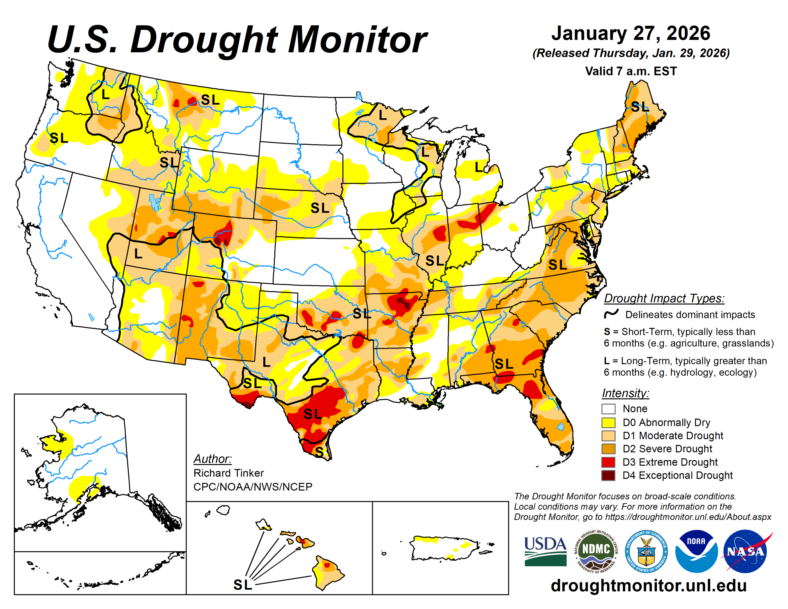
Most precipitation across the contiguous United States fell in association with a large, impactful storm system that affected a broad area of the country.
From the southernmost Rockies and the Southern Plains eastward across a large part of the Mississippi and Ohio Valleys, the Southeast, and the Eastern Seaboard were hit the hardest. Winter storm warnings at one point covered about 1 million square miles. Heavy to excessive amounts of snow, sleet, and freezing rain were widespread throughout the region.
Snow and sleet totals reached 15 inches in Oklahoma and Missouri and 1 foot in Arkansas. Intense sleet fell farther south, overlapping the southern sections of the heavy snow area. Sleet totals topped out near 7 inches in Arkansas and near or slightly over 6 inches fell on scattered sites across Oklahoma and Texas.
Freezing rain fell in abundance across portions of the South, and in some areas that experienced a changeover from sleet. States with at least one site reporting 1-inch-thick ice accumulation included Oklahoma. Peak amounts of 0.7- to 0.8-inch were reported in Texas. Widespread power outages and tree damage were reported in many locations that received heavy freezing rain. Liquid-equivalent precipitation totals associated with this system exceeded an inch in parts of the southernmost Rockies, in a band that included eastern Texas and western Arkansas. Scattered areas across the southern tier of the Lower-48 recorded over 3 inches of precipitation, including central Texas and adjacent Texas, and a fairly solid band from northeastern Texas through northern Louisiana, northern Mississippi, and northwestern Alabama.
Despite the extensive coverage of impactful precipitation, the storm has not yet brought about broad areas of drought relief. Improvements were made where some of the heaviest liquid-equivalent precipitation fell, including a few places where it fell in frozen form.
Along the northwestern and southeastern edges of the winter storm, light to moderate precipitation was recorded, with totals ranging from a few tenths to nearly an inch over the western half of Texas and from much of Oklahoma northeastward through most of Missouri.
In other parts of the Lower-48, very little precipitation was recorded. The single widespread and extremely impactful winter storm was responsible for almost all of the precipitation observed.
The U.S. Drought Monitor is jointly produced by the National Drought Mitigation Center at the University of Nebraska-Lincoln, the U.S. Department of Agriculture and the National Oceanic Atmospheric Administration. (Map courtesy of NDMC.)
South
One to several inches of precipitation were widespread across central and southern Arkansas and eastern Texas. Improvements were introduced in several areas. The areas that received the most precipitation fell where drought was already waning.
Despite the precipitation accompanying the massive winter storm, many areas in a band from northern Arkansas to the Louisiana Gulf Coast recorded 8 to 10 inches less than normal precipitation over the past 90 days. A few spots in northeastern Arkansas and east-central Louisiana recorded deficits approaching 12 inches during this period. Farther west, moderate to heavy precipitation was fairly widespread in eastern Texas, with lesser amounts toward the central part of the state. Southeastern Oklahoma reported amounts similar to eastern Texas (1.5 to locally 3 inches), but most areas farther northwest recorded less than an inch.
With much of the precipitation remaining locked up in frozen form, only a few improvements were introduced in the areas with the most extreme totals in eastern Texas. A few inches of liquid-equivalent precipitation also fell farther southwest over south-central Texas. Temperatures were above freezing there at the end of the period, and the environment was beginning to respond to the moisture infusion, so somewhat more aggressive improvements were introduced there.
Midwest
Central and southern Missouri recorded 0.5 to 1 inch. A swath from northern Missouri through northwestern Ohio were on the periphery of the storm and recorded only a few tenths of an inch.
Across Minnesota and Iowa, little or no precipitation fell. Drought improvement was introduced in parts Missouri where over 1.5 inches fell. Elsewhere, bitterly cold conditions kept the ground frozen and squelched both human and environmental moisture demands, so drought remained unchanged across Missouri and most areas north of the Ohio River.
High Plains
Most of the High Plains region was dry last week, with amounts of a few tenths to approaching an inch fell on much of central and eastern Kansas and on scattered higher elevations in Colorado and Wyoming.
Otherwise, little or nothing fell. The region—outside the higher elevations—is climatologically cold and dry, so precipitation deficits increase very slowly, and demand is lower this time of year. Dryness and drought were essentially unchanged in most of the High Plains region, with some scattered deterioration introduced in parts of western Colorado (to D1 or D2).
Drought intensification was also introduced around the Black Hills and adjacent western South Dakota (to D0 or D1), where snowpack is deficient and slowly declining.
West
The southern fringe of the West Region was impacted by the western edge of the winter storm, resulting in over 1.5 inches of precipitation across a few patches across southern New Mexico.
Amounts exceeded 3 inches in parts of south-central New Mexico north of the Texas Big Bend. The precipitation fell mostly in liquid form in southeastern Arizona and was sufficient to bring improvements into that area. Farther east, although amounts were a little heavier, the precipitation was primarily in frozen form and remained unmelted.
Only a few targeted improvements were introduced in a few small areas reporting the highest precipitation amounts (over 3 inches). Elsewhere, most of the region received no measurable precipitation, with just a few tenths falling on some of the higher elevations of the Rockies.
Still, there was no tangible deterioration across the region during the dry week, in part because it followed a few weeks of relatively abundant precipitation. The Drought Monitor depiction was unchanged outside parts of the southern fringes of Arizona and New Mexico.
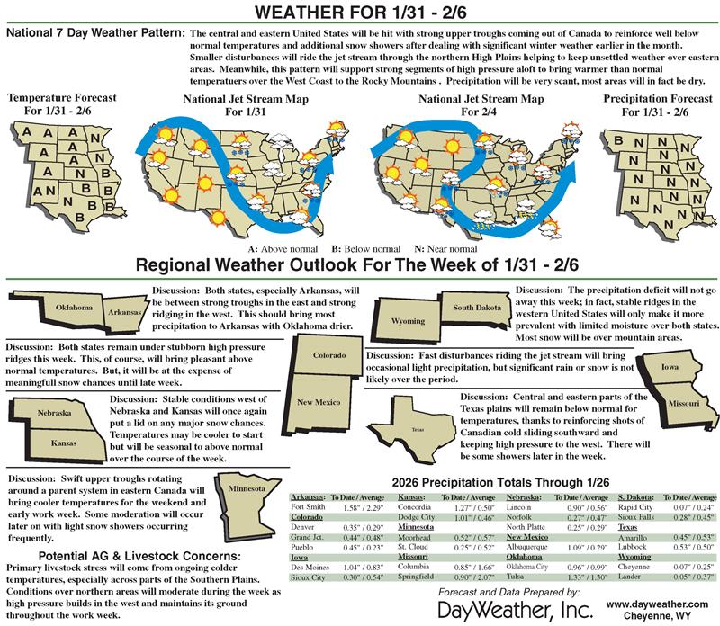
Looking ahead
Not much precipitation is expected across the contiguous U.S.
Moderate to heavy precipitation is also expected over the western half of Washington and adjacent Oregon. The Washington Cascades and far northwestern Washington are expecting 2.5 to 5 inches of precipitation, with totals ranging from near 1 to 2.5 inches in the rest of the area.
Only light to locally moderate precipitation is forecast elsewhere across the contiguous U.S. Several tenths to an inch may fall on northern Idaho, and a few tenths of an inch are forecast across some of the higher elevations of Wyoming and Colorado and parts of the Northern Plains. Light amounts at best are expected elsewhere across most of the contiguous U.S.
Meanwhile, the pattern featuring abnormally cold weather in the eastern half of the Lower-48 and unseasonably mild temperatures farther west. Subnormal temperatures are expected across a broad area from the central and southern Great Plains eastward and northeastward through the Eastern Seaboard outside northern New England.
Farther west, above-normal temperatures are expected to cover most areas from the High Plains to the West Coast. Temperatures are expected to average 10 to approaching 15 degrees Fahrenheit above normal across the Great Basin, northern Intermountain West, and the central and northern sections of the Rockies and High Plains.
The 6- to 10-day outlook for Feb. 3 to 7 depicts an eastward expansion of abnormal warmth into the middle of the Lower-48. Odds for above-normal temperatures increase moving westward, with chances of at least 80% in place over parts of the northern High Plains and from the western Rockies to the Pacific Coast. Increased odds for surplus precipitation in the Lower-48 are limited to the Southern Plains. Meanwhile, enhanced chances for subnormal precipitation covers the Northern Plains and most areas from the Rockies to the Pacific Ocean.
Richard Tinker is with NOAA/NWS/NCEP/CPC.
Related Articles


