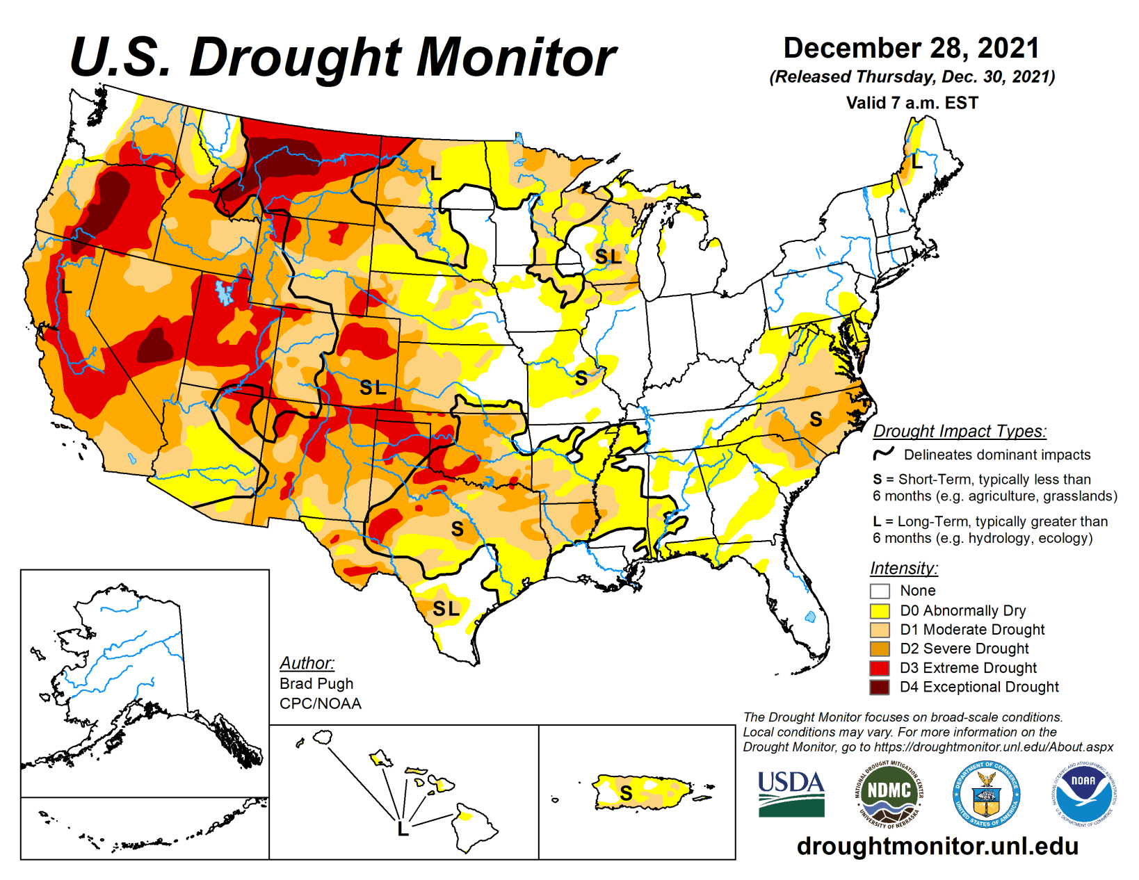
A persistent pattern over the North Pacific and western North America maintained a continuation of frequent storms affecting the West Coast through late December. On Dec. 23 and 24, a strong low pressure system tracked inland from the East Pacific and resulted in widespread precipitation of 0.5 to 3 inches, liquid equivalent, across much of southern California along with the Great Basin, Southwest, and Four Corners region.
Dry weather with much above normal temperatures persisted throughout the central and southern Great Plains. As of Dec. 28, month-to-date temperatures have averaged more than 7 degrees F above normal across the south-central U.S. Eastern North Dakota and the upper Mississippi Valley received another round of precipitation (0.25 to 0.75 inches, liquid equivalent) this past week. Following a period of widespread rainfall across much of the Ozarks region, lower Mississippi Valley, and Southeast during mid-December, dry weather returned to these areas from Dec 21 to 27. Little or no precipitation continued through late December across the Mid-Atlantic. The wet pattern, typical of La Nina winters, continues to affect Hawaii.
South
Based on persistent dryness, periods of enhanced winds and anomalous warmth this month, and worsening soil moisture conditions, a broad 1-category degradation was made to much of Oklahoma and the Texas Panhandle. Most locations across southwestern Oklahoma along with the Oklahoma and Texas Panhandles have received less than 0.10 inch of precipitation during the past 70 to 80 days. As of Dec. 28, Amarillo, Texas, has observed no precipitation for 76 consecutive days, which is the second longest dry streak on record. Additional expansion of various Dx levels was also made across much of the remainder of Texas due to persistent dryness and much above normal temperatures. Month-to-date temperatures, as of December 28, have averaged more than 8 degrees F above normal throughout nearly all of Oklahoma and Texas. The current depiction of conditions across Arkansas, Louisiana, and Mississippi was a balance among SPI values, soil moisture, and 28-day average streamflows. During the past 90 days, precipitation has averaged less than 50 percent of normal throughout much of the lower Mississippi Valley.
Midwest
Another week of widespread precipitation (more than 0.5 inch, liquid equivalent) along with positive SPI values dating back 6 months supported a slight decrease in abnormal dryness (D0), moderate drought (D1), and severe drought (D2) across parts of Minnesota. However, there are continued long-term precipitation deficits for parts of the upper Mississippi Valley including International Falls, Minnesota which has a 5 inch deficit for 2021 as of Dec. 28. A small improvement was also made to parts of western Wisconsin that received around 0.75 inches of precipitation this past week. Based on 120-day SPI, moderate (D1) to severe (D2) drought was expanded slightly across southern Wisconsin. Increasing short-term deficits resulted in a slight expansion of abnormal dryness (D0) across parts of Missouri. A small area of severe drought (D2) was added to the west of St Louis based on short-term SPIs and 28-day streamflows.
High Plains
A continued expansion of abnormal dryness (D0), moderate drought (D1), and severe drought (D2) were required again this week across much of Kansas due to worsening soil moisture indicators, 90 to 120-day SPIs, declining streamflows, and impacts such as cattle sell-offs. A 1-category degradation was made to the southwest corner of Nebraska based on soil moisture and SPI values at various time scales. A recent increase in snowpack led to improving drought conditions across the central Rockies, to the west of the Continental Divide. Severe (D2) to extreme (drought) was expanded across northeast Colorado due to declining soil moisture indicators and EDDI. Precipitation (more than 0.5 inch, liquid equivalent) on Dec 26 along with positive SPI values dating back 6 months supported a slight decrease in abnormal dryness (D0) and moderate drought (D1) across central and eastern North Dakota.
West
Heavy December precipitation, SWE numbers, and 12- to 24-month SPIs supported a large 1-category improvement to California along with parts of Nevada and Utah. The SWE is 150 to 250 percent of normal throughout the Sierras for this time of year. The Central Sierra snow lab has observed 193.7 inches of snowfall this month which is a December record. 179 inches, set in 1970, was the previous record for December. As of Dec. 28, the California statewide average of snow water content is 159 percent of normal for that date. Given the favorable snowpack and heavy precipitation during December, additional improvements may be warranted for California during subsequent weeks. Widespread, heavy precipitation (1 to 3 inches, liquid equivalent) resulted in a 1-category improvement across parts of Arizona and Utah where the heaviest amounts occurred and also supported by 12-month SPI values. A 1-category improvement was also made to much of northern and central Idaho along with adjacent areas of northwest Montana based on near to above normal SWE and 24-month SPI. A sharp gradient in drought conditions exists from west to east along the Continental Divide. During the past 14 days, parts of southeast Washington and northeast Oregon have received more than 2 inches of precipitation, liquid equivalent. This recent heavy precipitation and favorable response from soil moisture and 28-day streamflow indicators prompted a slight improvement to those areas. The longer term SPEI, which includes the record heat earlier this summer, continues to support extreme (D3) to exceptional (D4) drought for central and eastern parts of Oregon and Washington. Along and to the west of the Cascades, additional improvements were made this week to western Oregon. A recent increase in snowfall prompted improving drought conditions across parts of northern New Mexico, while all of northeast New Mexico is now designated with severe (D2) to extreme (D3) drought. No precipitation has been observed at Clayton, New Mexico for 76 days which is the 5th longest streak on record.


